
Make a donation
Gear up for your next adventure:
As an Amazon Associate, this site earns from qualifying purchases at no extra cost to you.
Bili Oslavy topographic map
Click on the map to display elevation.
Make a donation
Gear up for your next adventure:
As an Amazon Associate, this site earns from qualifying purchases at no extra cost to you.
About this map
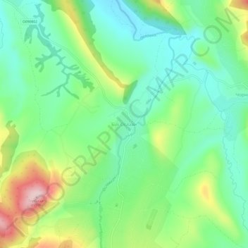
Name: Bili Oslavy topographic map, elevation, terrain.
Average elevation: 1,673 ft
Minimum elevation: 1,391 ft
Maximum elevation: 2,247 ft
Make a donation
Gear up for your next adventure:
As an Amazon Associate, this site earns from qualifying purchases at no extra cost to you.
Other topographic maps
Click on a map to view its topography, its elevation and its terrain.
Lviv
Lviv is on the edge of the Roztochia Upland, about 70 kilometres (43 miles) east of Polish border and 160 km (99 mi) north of the eastern Carpathian Mountains. The average altitude of Lviv is 296 metres (971 feet) above sea level. Its highest point is the Vysokyi Zamok (High Castle), 409 meters (1342 feet)…
Average elevation: 1,014 ft
Bakhmut
Bakhmut, located in the Donetsk Oblast of eastern Ukraine, lies in a region characterized by relatively flat terrain, with its elevation around 328 feet (100 meters) above sea level. The city is situated along the Bakhmutka River, which contributes to the area's relatively mild topographic features. The…
Average elevation: 456 ft
Crimean Peninsula
The main range of these mountains rises with extraordinary abruptness from the deep floor of the Black Sea to an altitude of 600–1,545 metres (1,969–5,069 ft), beginning at the southwest point of the peninsula, called Cape Fiolent. Some Greek myths state that this cape was supposedly crowned with the…
Average elevation: 115 ft
Make a donation
Gear up for your next adventure:
As an Amazon Associate, this site earns from qualifying purchases at no extra cost to you.
Make a donation
Gear up for your next adventure:
As an Amazon Associate, this site earns from qualifying purchases at no extra cost to you.
Make a donation
Gear up for your next adventure:
As an Amazon Associate, this site earns from qualifying purchases at no extra cost to you.
Kyiv
Originally on the west bank, today Kyiv is on both sides of the Dnieper, which flows southwards through the city towards the Black Sea. The older and higher western part of the city sits on numerous wooded hills (Kyiv Hills), with ravines and small rivers. Kyiv's geographical relief contributed to its…
Average elevation: 436 ft
Kyiv
Originally on the west bank, today Kyiv is located on both sides of the Dnieper, which flows southwards through the city towards the Black Sea. The older and higher western part of the city sits on numerous wooded hills (Kyiv Hills), with ravines and small rivers. Kyiv's geographical relief contributed to its…
Average elevation: 436 ft
Make a donation
Gear up for your next adventure:
As an Amazon Associate, this site earns from qualifying purchases at no extra cost to you.
Lviv
Lviv is on the edge of the Roztochia Upland, about 70 kilometres (43 miles) east of Polish border and 160 km (99 mi) north of the eastern Carpathian Mountains. The average altitude of Lviv is 296 metres (971 feet) above sea level. Its highest point is the Vysokyi Zamok (High Castle), 409 meters (1342 feet)…
Average elevation: 1,014 ft
Make a donation
Gear up for your next adventure:
As an Amazon Associate, this site earns from qualifying purchases at no extra cost to you.
Kyiv
Originally on the west bank, today Kyiv is on both sides of the Dnieper, which flows southwards through the city towards the Black Sea. The older and higher western part of the city sits on numerous wooded hills (Kyiv Hills), with ravines and small rivers. Kyiv's geographical relief contributed to its…
Average elevation: 436 ft
Make a donation
Gear up for your next adventure:
As an Amazon Associate, this site earns from qualifying purchases at no extra cost to you.
Kharkiv
Based on Kharkiv's topography, the city can be conditionally divided into four lower districts and four higher districts.
Average elevation: 479 ft
Make a donation
Gear up for your next adventure:
As an Amazon Associate, this site earns from qualifying purchases at no extra cost to you.
Dnieper River
The source of the Dnieper is the sedge bogs (Akseninsky Mokh) of the Valdai Hills in central Russia, at an elevation of 220 m (720 ft). For 115 km (71 mi) of its length, it serves as the border between Belarus and Ukraine. Its estuary, or liman, used to be defended by the strong fortress of Ochakiv.
Average elevation: 636 ft
Make a donation
Gear up for your next adventure:
As an Amazon Associate, this site earns from qualifying purchases at no extra cost to you.
Make a donation
Gear up for your next adventure:
As an Amazon Associate, this site earns from qualifying purchases at no extra cost to you.
Zaporizhzhia
Zaporizhzhia is located in south-eastern Ukraine. The Dnieper splits the city in two; between them is Khortytsia Island. The city covers 334 km2 (129 sq mi) at an elevation of 50 m (160 ft) above sea level. The New and Old Dnieper flow past around Khortytsia: The New Dnieper [uk] is about 800 m (2,600 feet)…
Average elevation: 256 ft
Make a donation
Gear up for your next adventure:
As an Amazon Associate, this site earns from qualifying purchases at no extra cost to you.
Make a donation
Gear up for your next adventure:
As an Amazon Associate, this site earns from qualifying purchases at no extra cost to you.
Ivano-Frankivsk Oblast
The Carpathian Mountains contribute tremendously to the change in relief of Ivano-Frankivsk Oblast and their elevation rises from north-east to south-west stretching along the oblast's south-western border. The elevation of the oblast varies from 230 m (755 ft) to 2,061 m (6,762 ft) above sea level. The…
Average elevation: 1,801 ft
Lviv
Lviv is on the edge of the Roztochia Upland, about 70 kilometres (43 miles) east of the Polish border and 160 km (99 mi) north of the eastern Carpathian Mountains. The average altitude of Lviv is 296 metres (971 feet) above sea level. Its highest point is the Vysokyi Zamok (High Castle), 409 meters (1,342…
Average elevation: 1,014 ft
Make a donation
Gear up for your next adventure:
As an Amazon Associate, this site earns from qualifying purchases at no extra cost to you.
Dnipro
Ukraine > Dnipropetrovsk Oblast
Under the Köppen–Geiger climate classification system, Dnipro has a humid continental climate (Dfa/Dfb). Snowfall is more common in the hills than at the city's lower elevations. The city has four distinct seasons: a cold, snowy winter; a hot summer; and two relatively wet transition periods. However,…
Average elevation: 295 ft
Crimean Peninsula
The main range of these mountains rises with extraordinary abruptness from the deep floor of the Black Sea to an altitude of 600–1,545 metres (1,969–5,069 ft), beginning at the southwest point of the peninsula, called Cape Fiolent. Some Greek myths state that this cape was supposedly crowned with the…
Average elevation: 115 ft
Make a donation
Gear up for your next adventure:
As an Amazon Associate, this site earns from qualifying purchases at no extra cost to you.
Zaporizhia Oblast
The territory of Zaporizhzhia Oblast as a whole has a flat topography, but there are markedly elevated and depressed areas, which differ in shape, origin, and age.
Average elevation: 246 ft
Kharkiv
Based on Kharkiv's topography, the city can be conditionally divided into four lower districts and four higher districts.
Average elevation: 479 ft
Make a donation
Gear up for your next adventure:
As an Amazon Associate, this site earns from qualifying purchases at no extra cost to you.
Zakarpattia Oblast
The largest rivers that flow through the oblast include the Tysa, Borzhava, and the Tereblia. A high altitude lake is located in Rakhiv Raion, which is the highest in the region. It is called Nesamovyte. The lake is located in the Hoverla preserve on the slopes of Turkul mountain. The lake's area is 3,000…
Average elevation: 1,798 ft
Make a donation
Gear up for your next adventure:
As an Amazon Associate, this site earns from qualifying purchases at no extra cost to you.
Odesa
The city is situated on terraced hills overlooking a small harbor. The average elevation at which the city is located is around 50 metres (160 feet). The maximum is 65 metres (213 feet) and minimum (on the coast) amounts to 4.2 metres (13.8 feet) above sea level. There are three large estuaries near the city:…
Average elevation: 85 ft
Make a donation
Gear up for your next adventure:
As an Amazon Associate, this site earns from qualifying purchases at no extra cost to you.
Odesa
Odesa is situated (46°28′N 30°44′E / 46.467°N 30.733°E / 46.467; 30.733) on terraced hills overlooking a small harbor on the Black Sea in the Gulf of Odesa, approximately 31 km (19 mi) north of the estuary of the Dniester river and some 443 km (275 mi) south of the Ukrainian capital Kyiv. The…
Average elevation: 85 ft
Make a donation
Gear up for your next adventure:
As an Amazon Associate, this site earns from qualifying purchases at no extra cost to you.
Make a donation
Gear up for your next adventure:
As an Amazon Associate, this site earns from qualifying purchases at no extra cost to you.
Skhidnytsia
Skhidnytsia located at an altitude of 600 metres (2,000 ft) – 900 metres (3,000 ft) above sea level. The mountains around the town reach a height of 823 metres (2,700 ft).
Average elevation: 2,044 ft
Make a donation
Gear up for your next adventure:
As an Amazon Associate, this site earns from qualifying purchases at no extra cost to you.
Mykolaiv
Mykolaiv is in a primarily flat terrain area (the steppe grain-producing region of southern Ukraine). The nearest mountains to Mykolaiv are 300 kilometres (186 miles) south, at the southern end of the Crimean Peninsula. The lack of any mountain barriers north of Mykolaiv means that very cold Arctic winds can…
Average elevation: 105 ft
Sumy Oblast
The Sumy Oblast is situated in the northeastern part of Ukraine. It is situated on a border of two historical regions of Ukraine — Cossack Hetmanate (annexed by Russia in the 18th century as Little Russia, previously known as Severia) and Sloboda Ukraine. Elevation is 110–240m above sea level. The area of…
Average elevation: 558 ft
Make a donation
Gear up for your next adventure:
As an Amazon Associate, this site earns from qualifying purchases at no extra cost to you.
Make a donation
Gear up for your next adventure:
As an Amazon Associate, this site earns from qualifying purchases at no extra cost to you.
Make a donation
Gear up for your next adventure:
As an Amazon Associate, this site earns from qualifying purchases at no extra cost to you.
Make a donation
Gear up for your next adventure:
As an Amazon Associate, this site earns from qualifying purchases at no extra cost to you.
Make a donation
Gear up for your next adventure:
As an Amazon Associate, this site earns from qualifying purchases at no extra cost to you.
Sumy Oblast
On its territory the Dnieper Lowland transitions east to the Central Russian Upland. The northern part of Sumy Oblast is part of the Polesie Lowland as its eastern region. Elevation is 110–240 m above sea level. Its area (23,800 km2) constitutes 3.95% of the country.
Average elevation: 558 ft
Make a donation
Gear up for your next adventure:
As an Amazon Associate, this site earns from qualifying purchases at no extra cost to you.