
包头市 topographic map
Interactive map
Click on the map to display elevation.
About this map
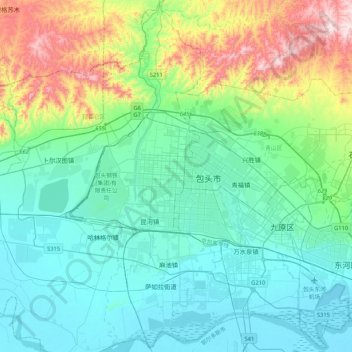
Name: 包头市 topographic map, elevation, terrain.
Location: 包头市, 内蒙古自治区, 014000, 中国 (40.49492 109.67446 40.81492 109.99446)
Average elevation: 3,780 ft
Minimum elevation: 3,284 ft
Maximum elevation: 5,545 ft
包头境内有阴山山脉的大青山、乌拉山(以昆都仑河为界),山峰平均海拔2000米,最高峰海拔2324米。全市由中部山岳地带、山北高原草地和山南平原三部分组成,呈中间高,南北低,西高东低的地势。
Other topographic maps
Click on a map to view its topography, its elevation and its terrain.