
Make a donation
Gear up for your next adventure:
As an Amazon Associate, this site earns from qualifying purchases at no extra cost to you.
Swat River topographic map
Click on the map to display elevation.
Make a donation
Gear up for your next adventure:
As an Amazon Associate, this site earns from qualifying purchases at no extra cost to you.
About this map
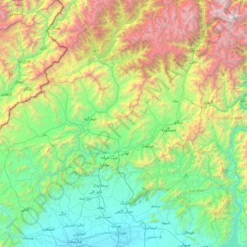
Name: Swat River topographic map, elevation, terrain.
Location: Swat River, Khyber Pakhtunkhwa, Pakistan (34.12133 71.48928 35.47937 72.61499)
Average elevation: 5,138 ft
Minimum elevation: 965 ft
Maximum elevation: 18,458 ft
Make a donation
Gear up for your next adventure:
As an Amazon Associate, this site earns from qualifying purchases at no extra cost to you.
Other topographic maps
Click on a map to view its topography, its elevation and its terrain.
Abbottabad
Pakistan > Khyber Pakhtunkhwa > Abbottābād District
Abbottabad (/ˈæbətəbɑːd/; Urdu, Hindko: ایبٹ آباد, romanized: aibṭabād, pronounced [ɛːbʈəˈbaːd̪]) is the capital city of Abbottabad District in the Hazara region of eastern Khyber Pakhtunkhwa, Pakistan. It is the 40th largest city in Pakistan and fourth largest in the province of Khyber…
Average elevation: 4,472 ft
Khyber Pakhtunkhwa
Most precipitation falls as thunderstorms or snow during winter and spring, so that the climate at the lowest elevations is classed as Mediterranean (Csa), continental Mediterranean (Dsa) or semi-arid (BSk). Summers are extremely dry in the north of Chitral district and receive only a little rain in the south…
Average elevation: 7,005 ft
Bumburait
Pakistan > Khyber Pakhtunkhwa > Chitrāl District > Chitral Tehsil
Average elevation: 8,025 ft
Make a donation
Gear up for your next adventure:
As an Amazon Associate, this site earns from qualifying purchases at no extra cost to you.
Make a donation
Gear up for your next adventure:
As an Amazon Associate, this site earns from qualifying purchases at no extra cost to you.
Mardan
Pakistan > Khyber Pakhtunkhwa > Mardān District
Mardan is located in the south west of the district at 34°12'0N 72°1'60E and an altitude of 283 metres (928 ft). Mardan is a district headquarter of Mardan District of Khyber Pakhtunkhwa. Risalpur is located to the south, Charsadda is located to the west, Yar Hussain to the east and Takht Bahi & Katlang to…
Average elevation: 1,076 ft
Junali Kuch
Pakistan > Khyber Pakhtunkhwa > Chitrāl District > Torkhow-Molkhow Tehsil
Average elevation: 7,211 ft
Make a donation
Gear up for your next adventure:
As an Amazon Associate, this site earns from qualifying purchases at no extra cost to you.
Hindu Kush
Pakistan > Khyber Pakhtunkhwa > Chitrāl District > Chitral Tehsil
Average elevation: 17,326 ft
Make a donation
Gear up for your next adventure:
As an Amazon Associate, this site earns from qualifying purchases at no extra cost to you.
Dera Ismail Khan
Pakistan > Khyber Pakhtunkhwa > Dera Ismail Khan District
D. I Khan is situated at an altitude of 177 metres above sea level.
Average elevation: 581 ft
Make a donation
Gear up for your next adventure:
As an Amazon Associate, this site earns from qualifying purchases at no extra cost to you.
Tirich Mir
Pakistan > Khyber Pakhtunkhwa > Chitrāl District > Torkhow-Molkhow Tehsil
The weather station 4,245 m (13,927 ft) above sea level lies in the Tundra climate/Alpine climate (ET) zone according to Köppen Climate Classification. On this specific altitude (4,245 m or 13,927 ft asl) we find moderately cold winters and cool summers generally above freezing. Annual mean temperature is…
Average elevation: 22,316 ft
Make a donation
Gear up for your next adventure:
As an Amazon Associate, this site earns from qualifying purchases at no extra cost to you.
Noshaq
Pakistan > Khyber Pakhtunkhwa > Chitrāl District > Torkhow-Molkhow Tehsil
Average elevation: 22,533 ft
Make a donation
Gear up for your next adventure:
As an Amazon Associate, this site earns from qualifying purchases at no extra cost to you.
Charsadda
Pakistan > Khyber Pakhtunkhwa > Charsadda District
Chārsadda (Pashto: چارسده; pronounce; Urdu: چارسدہ; pronounce) is a town and headquarters of Charsadda District, in the Khyber Pakhtunkhwa province of Pakistan. It is the 85th-largest city of Pakistan, according to 2017 census. Located in the Valley of Peshawar, Charsadda lies about 29 kilometres…
Average elevation: 1,040 ft
Dir
Pakistan > Khyber Pakhtunkhwa > Upper Dir District
The topography of Upper Dir is dominated by high mountains. The most important mountain range is the Hindu Kush. It runs from north east to south west along the northern borders with Chitral District. In winter whole area remains snow-covered. The mountains in the western part of the district are covered with…
Average elevation: 7,231 ft
Make a donation
Gear up for your next adventure:
As an Amazon Associate, this site earns from qualifying purchases at no extra cost to you.
Make a donation
Gear up for your next adventure:
As an Amazon Associate, this site earns from qualifying purchases at no extra cost to you.
Dir Gol
Pakistan > Khyber Pakhtunkhwa > Chitrāl District > Chitral Tehsil
Average elevation: 12,267 ft
Dera Ismail Khan
Pakistan > Khyber Pakhtunkhwa > Dera Ismail Khan District
D. I Khan is situated at an altitude of 177 metres above sea level.
Average elevation: 581 ft
Swat
Pakistan > Khyber Pakhtunkhwa > Charsadda District > بانڈہ سیداں > بِجلۍ کورونه
Average elevation: 1,214 ft
Make a donation
Gear up for your next adventure:
As an Amazon Associate, this site earns from qualifying purchases at no extra cost to you.
Abbottabad
Pakistan > Khyber Pakhtunkhwa > Abbottābād District
Abbottabad is a city in the Hazara Division of Khyber Pakhtunkhwa province, Pakistan. It is the 40th largest city in the country and 6th largest in the province by population, and serves as the headquarter of its namesake tehsil and district. It is about 120 km (75 mi) north of Islamabad-Rawalpindi and 150 km…
Average elevation: 4,472 ft
Make a donation
Gear up for your next adventure:
As an Amazon Associate, this site earns from qualifying purchases at no extra cost to you.
Swat
Pakistan > Khyber Pakhtunkhwa > Charsadda District > بانڈہ سیداں > بِجلۍ کورونه
Average elevation: 1,214 ft
Make a donation
Gear up for your next adventure:
As an Amazon Associate, this site earns from qualifying purchases at no extra cost to you.
Make a donation
Gear up for your next adventure:
As an Amazon Associate, this site earns from qualifying purchases at no extra cost to you.
Chitral
Pakistan > Khyber Pakhtunkhwa > Chitrāl District
The city has an average elevation of 1,500 m (4,921 ft).
Average elevation: 9,783 ft
Chitral
Pakistan > Khyber Pakhtunkhwa > Chitrāl District
The city has an average elevation of 1,500 m (4,921 ft).
Average elevation: 9,783 ft
Make a donation
Gear up for your next adventure:
As an Amazon Associate, this site earns from qualifying purchases at no extra cost to you.
Make a donation
Gear up for your next adventure:
As an Amazon Associate, this site earns from qualifying purchases at no extra cost to you.
Abbottabad
Pakistan > Khyber Pakhtunkhwa > Abbottābād District
Abbottabad is a city in the Hazara Division of Khyber Pakhtunkhwa province, Pakistan. It is the 40th largest city in the country and 6th largest in the province by population, and serves as the headquarter of its namesake tehsil and district. It is about 120 km (75 mi) north of Islamabad-Rawalpindi and 150 km…
Average elevation: 4,472 ft
Make a donation
Gear up for your next adventure:
As an Amazon Associate, this site earns from qualifying purchases at no extra cost to you.
Chitral
Pakistan > Khyber Pakhtunkhwa > Chitrāl District
The city has an average elevation of 1,500 m (4,921 ft).
Average elevation: 9,783 ft
Kohat
Pakistan > Khyber Pakhtunkhwa > Kohat District
Kohat city is located at an altitude of 489 metres (1,604 ft). Kohat Pass lies to the north. It is situated on the left bank of the Toi river at a point where after running nearly due east for 50 miles (80 km), it turns to the south. The total area of the district is 2,545 square kilometres (983 sq mi)
Average elevation: 2,369 ft
Make a donation
Gear up for your next adventure:
As an Amazon Associate, this site earns from qualifying purchases at no extra cost to you.
Make a donation
Gear up for your next adventure:
As an Amazon Associate, this site earns from qualifying purchases at no extra cost to you.
Make a donation
Gear up for your next adventure:
As an Amazon Associate, this site earns from qualifying purchases at no extra cost to you.
Adina
Pakistan > Khyber Pakhtunkhwa > Swabi District
Adina is a town and union council of Swabi District in Khyber Pakhtunkhwa. It is located at an altitude of 303 metres (997 feet).
Average elevation: 1,240 ft
Make a donation
Gear up for your next adventure:
As an Amazon Associate, this site earns from qualifying purchases at no extra cost to you.
Bamburait River
Pakistan > Khyber Pakhtunkhwa > Chitrāl District > Chitral Tehsil
Average elevation: 9,839 ft
Make a donation
Gear up for your next adventure:
As an Amazon Associate, this site earns from qualifying purchases at no extra cost to you.
Chitral
Pakistan > Khyber Pakhtunkhwa > Chitrāl District
The city has an average elevation of 1,500 m (4,921 ft).
Average elevation: 9,783 ft
Noshaq
Pakistan > Khyber Pakhtunkhwa > Chitrāl District > Torkhow-Molkhow Tehsil
Average elevation: 22,533 ft
Make a donation
Gear up for your next adventure:
As an Amazon Associate, this site earns from qualifying purchases at no extra cost to you.
Drosh
Pakistan > Khyber Pakhtunkhwa > Chitrāl District
Drosh is low elevation and is a large village in Chitral District on the traditional trade route to Drosh-Jalalabad Road. Drosh is located on 35° 33' 33" N and 71° 47' 44" E on the banks of the Landai Sin River (Bashgal River) just above its intersection with the Kunar River (Chitral River), along the…
Average elevation: 6,073 ft
Chitral
Pakistan > Khyber Pakhtunkhwa > Chitrāl District
The city has an average elevation of 1,500 m (4,921 ft).
Average elevation: 9,783 ft
Peshawar Cantonment
Pakistan > Khyber Pakhtunkhwa > Peshāwar District > Peshawar City Tehsil
Average elevation: 1,155 ft
Make a donation
Gear up for your next adventure:
As an Amazon Associate, this site earns from qualifying purchases at no extra cost to you.
Indus
Pakistan > Khyber Pakhtunkhwa > Swabi District > Allāhdher
In the uppermost, highest part of the Indus River basin there are relatively few genera and species: Diptychus, Ptychobarbus, Schizopyge, Schizopygopsis and Schizothorax snowtrout, Triplophysa loaches, and the catfish Glyptosternon reticulatum. Going downstream these are soon joined by the golden mahseer Tor…
Average elevation: 922 ft
Battagram
Pakistan > Khyber Pakhtunkhwa > Battagram District
Battagram (Urdu: بٹگرام, Pashto: بټګرام) is a city and Union Council of Battagram District in Khyber Pakhtunkhwa Province of Pakistan. It is located at 34°41'N 73°1'E and has an altitude of 1038 metres (3408 feet).
Average elevation: 4,318 ft
Make a donation
Gear up for your next adventure:
As an Amazon Associate, this site earns from qualifying purchases at no extra cost to you.
Make a donation
Gear up for your next adventure:
As an Amazon Associate, this site earns from qualifying purchases at no extra cost to you.