
协格尔镇 topographic map
Interactive map
Click on the map to display elevation.
About this map
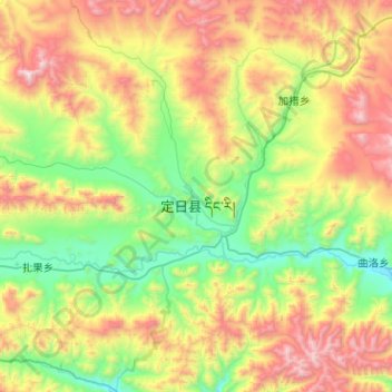
Name: 协格尔镇 topographic map, elevation, terrain.
Location: 协格尔镇, 定日县, 日喀则市, 西藏自治区, 中国 (28.51407 86.79556 28.82690 87.30459)
Average elevation: 15,850 ft
Minimum elevation: 13,727 ft
Maximum elevation: 19,800 ft
协格尔镇(藏語:ཤེལ་དཀར།,威利转写:shelkhar,意為“草坪山”)是中华人民共和国西藏自治区日喀则市定日县下辖的一个乡镇级行政单位,也是定日縣縣政府所在地,人口大约523人。该镇是攀登珠穆朗玛峰 和卓奥友峰的登山者的一个大本营。协格尔镇位于珠穆朗玛峰西北方向,距珠穆朗玛峰约60公里。距中尼边境约50公里。 海拔4300米。该镇是一个为攀登珠穆朗玛峰而设立的新镇。
Other topographic maps
Click on a map to view its topography, its elevation and its terrain.