
克玛乡 topographic map
Interactive map
Click on the map to display elevation.
About this map
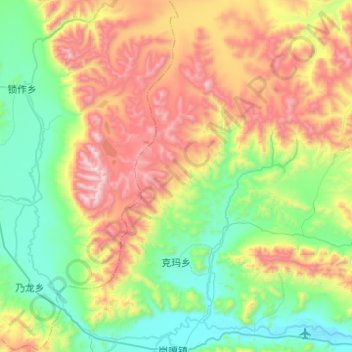
Name: 克玛乡 topographic map, elevation, terrain.
Location: 克玛乡, 定日县, 日喀则市, 西藏自治区, 858200, 中国 (28.61010 86.52991 28.98728 87.02404)
Average elevation: 15,922 ft
Minimum elevation: 14,094 ft
Maximum elevation: 19,613 ft
Other topographic maps
Click on a map to view its topography, its elevation and its terrain.