Geolocate

Bentley topographic map

Click on the map to display elevation.

About this map

Name: Bentley topographic map, elevation, terrain.

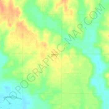
Location: Bentley, Atoka County, Oklahoma, United States (34.19482 -96.09888 34.23482 -96.05888)

Average elevation: 541 ft

Minimum elevation: 472 ft

Maximum elevation: 617 ft

Atoka County trails, hiking, mountain biking, running and outdoor activities

Other topographic maps

Click on a map to view its topography, its elevation and its terrain.

Atoka

United States > Oklahoma > Atoka County

Average elevation: 604 ft

Caney

United States > Oklahoma > Atoka County

Average elevation: 554 ft

Tushka

United States > Oklahoma > Atoka County

Average elevation: 617 ft

Stringtown

United States > Oklahoma > Atoka County

Average elevation: 646 ft

Gear up for your next adventure:

😴Insulated Sleeping Pads - Compact and warm pads for high-elevation camping
🔥Fast-Boil Camping Stoves - Efficient cooking systems for quick trail meals
🧦Merino Wool Socks - Moisture-wicking, blister-preventing socks for long treks
👓Polarized Sunglasses - Outdoor sunglasses for glare reduction
🩳Quick‑Dry Hiking Shorts - Comfortable and quick‑dry shorts for summer hiking

As an Amazon Associate, this site earns from qualifying purchases at no extra cost to you.