Geolocate

Atoka topographic map

Click on the map to display elevation.

About this map

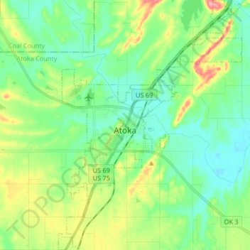
Name: Atoka topographic map, elevation, terrain.

Location: Atoka, Atoka County, Oklahoma, United States (34.33123 -96.16451 34.44112 -96.06670)

Average elevation: 604 ft

Minimum elevation: 515 ft

Maximum elevation: 801 ft

Atoka County trails, hiking, mountain biking, running and outdoor activities

Other topographic maps

Click on a map to view its topography, its elevation and its terrain.

Wesley

United States > Oklahoma > Atoka County

Average elevation: 820 ft

Limestone Gap

United States > Oklahoma > Atoka County

Average elevation: 761 ft

Hopewell

United States > Oklahoma > Atoka County

Average elevation: 719 ft

Farris

United States > Oklahoma > Atoka County

Average elevation: 535 ft

Chockie

United States > Oklahoma > Atoka County

Average elevation: 725 ft

Daisy

United States > Oklahoma > Atoka County

Average elevation: 823 ft

Wardville

United States > Oklahoma > Atoka County

Average elevation: 689 ft

Bentley

United States > Oklahoma > Atoka County

Average elevation: 541 ft

Redden

United States > Oklahoma > Atoka County

Average elevation: 722 ft

Gear up for your next adventure:

🪶Survival Guide Book - Expert advice for emergency preparedness
👟Trail Running Shoes - Lightweight shoes for trail runners
🥾Men's Hiking Boots - Durable, waterproof footwear for rugged terrain and steep inclines
🔋Rechargeable Batteries - Power up your outdoor devices
🕶️Glacier Sunglasses - Side shields to protect eyes from high-altitude snow glare

As an Amazon Associate, this site earns from qualifying purchases at no extra cost to you.