Geolocate

Tushka topographic map

Click on the map to display elevation.

About this map

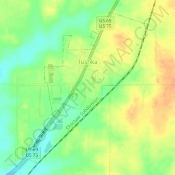
Name: Tushka topographic map, elevation, terrain.

Location: Tushka, Atoka County, Oklahoma, United States (34.30468 -96.17888 34.32806 -96.15609)

Average elevation: 617 ft

Minimum elevation: 558 ft

Maximum elevation: 669 ft

Atoka County trails, hiking, mountain biking, running and outdoor activities

Other topographic maps

Click on a map to view its topography, its elevation and its terrain.

Wesley

United States > Oklahoma > Atoka County

Average elevation: 820 ft

Limestone Gap

United States > Oklahoma > Atoka County

Average elevation: 761 ft

Hopewell

United States > Oklahoma > Atoka County

Average elevation: 719 ft

Farris

United States > Oklahoma > Atoka County

Average elevation: 535 ft

Chockie

United States > Oklahoma > Atoka County

Average elevation: 725 ft

Daisy

United States > Oklahoma > Atoka County

Average elevation: 823 ft

Wardville

United States > Oklahoma > Atoka County

Average elevation: 689 ft

Bentley

United States > Oklahoma > Atoka County

Average elevation: 541 ft

Redden

United States > Oklahoma > Atoka County

Average elevation: 722 ft

Gear up for your next adventure:

🔌Solar Panel Charger - Charge gear sustainably outdoors
🖼️Topo Map Wall Art - Decorative topographic prints of famous peaks and regions
🌄Hiking Binoculars - Compact binoculars for scenic views and trail spotting
🚗GPS Dash Cams - Record your scenic drives through mountain passes and canyons
🧢Outdoor Hiking Hat - Sun protection hat for outdoor explorers

As an Amazon Associate, this site earns from qualifying purchases at no extra cost to you.