Geolocate

Eagle topographic map

Interactive map

Click on the map to display elevation.

About this map

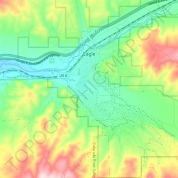
Name: Eagle topographic map, elevation, terrain.

Location: Eagle, Eagle County, Colorado, 81631, United States (39.61008 -106.84433 39.67371 -106.78342)

Average elevation: 6,932 ft

Minimum elevation: 6,467 ft

Maximum elevation: 7,733 ft

Eagle County trails, hiking, mountain biking, running and outdoor activities

Other topographic maps

Click on a map to view its topography, its elevation and its terrain.

Vail

United States > Colorado > Eagle County

Vail's average elevation is 8,150 feet (2484 m) above sea level. The town has a total area of 4.5 square miles (12 km2), with no lakes (there is, however, at least one pond). Gore Creek flows from east to west through the center of town.

Average elevation: 9,688 ft

Vail Mountain

United States > Colorado > Eagle County

Average elevation: 10,515 ft

Beaver Creek

United States > Colorado > Eagle County

Average elevation: 8,944 ft

East Vail Falls

United States > Colorado > Eagle County > Vail

Average elevation: 9,259 ft

Burns

United States > Colorado > Eagle County

Average elevation: 6,877 ft

Edwards

United States > Colorado > Eagle County > Edwards

Average elevation: 8,524 ft

McCoy

United States > Colorado > Eagle County > McCoy

Average elevation: 6,978 ft

Bighorn

United States > Colorado > Eagle County > Vail > Bighorn

Average elevation: 9,495 ft

Fulford

United States > Colorado > Eagle County > Fulford

Average elevation: 10,213 ft

Basalt

United States > Colorado > Eagle County

Average elevation: 6,650 ft

Dotsero

United States > Colorado > Eagle County > Dotsero

Average elevation: 6,631 ft

Dell

United States > Colorado > Eagle County > Dell

Average elevation: 6,860 ft