
门布乡 topographic map
Interactive map
Click on the map to display elevation.
About this map
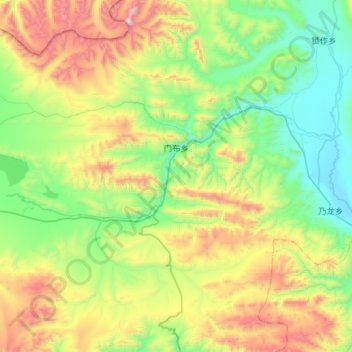
Name: 门布乡 topographic map, elevation, terrain.
Location: 门布乡, 聂拉木县, 日喀则市, 西藏自治区, 中国 (28.45952 85.98240 28.96301 86.42322)
Average elevation: 16,276 ft
Minimum elevation: 14,268 ft
Maximum elevation: 21,089 ft
Other topographic maps
Click on a map to view its topography, its elevation and its terrain.