
樟木镇 topographic map
Interactive map
Click on the map to display elevation.
About this map
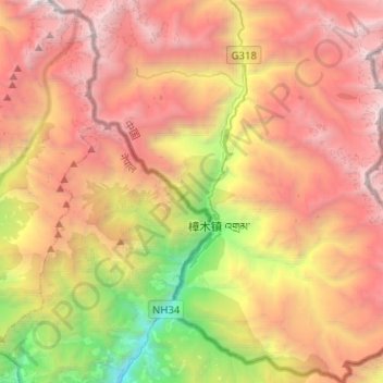
Name: 樟木镇 topographic map, elevation, terrain.
Location: 樟木镇, 聂拉木县, 日喀则市, 西藏自治区, 中国 (27.89981 85.89596 28.12328 86.12616)
Average elevation: 12,661 ft
Minimum elevation: 4,183 ft
Maximum elevation: 20,394 ft
樟木镇(藏語:འགྲམ་,威利转写:'gram)是中国西藏自治区日喀则市聂拉木县下辖的一个镇。樟木古称“塔觉嘎布”,藏语的意思是“邻近的口岸”,尼泊尔卡斯族人称之为『卡薩』;该镇地处中尼交界,喜马拉雅山南麓沟谷坡地上,距拉萨736公里,距加德满都120公里。它的海拔高度为2300米。位于该镇境内的樟木口岸是西藏最大通商口岸,但在2015年4月尼泊尔地震后被关闭,直到2019年5月29日重新开放。
Other topographic maps
Click on a map to view its topography, its elevation and its terrain.