
Snellville topographic map
Interactive map
Click on the map to display elevation.
About this map
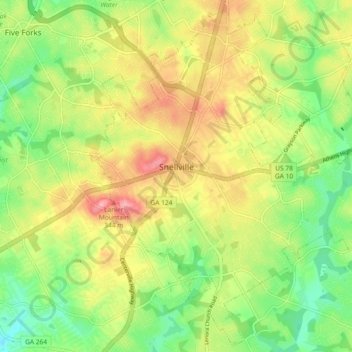
Name: Snellville topographic map, elevation, terrain.
Location: Snellville, Gwinnett County, Georgia, United States (33.81839 -84.04291 33.89217 -83.95093)
Average elevation: 984 ft
Minimum elevation: 810 ft
Maximum elevation: 1,191 ft
Compared to most large cities around the world at approximately the same latitude (33°39'), such as Beirut, Casablanca, Dallas, Los Angeles, and Phoenix, Snellville has lower average winter temperatures. The primary reason for this is that the North American continent extends into high latitudes that allows systems to form and move eastward and southward without obstruction by major mountain ranges. Other factors include Snellville's distance from large bodies of water; its higher elevation, which can lead to rapid weather changes; prevailing wind patterns; and extensive tree cover, which reduces the urban heat island effect (an advantage during summer).
Other topographic maps
Click on a map to view its topography, its elevation and its terrain.
Suwanee
United States > Georgia > Gwinnett County
Suwanee, Gwinnett County, Georgia, United States
Average elevation: 1,020 ft
Lawrenceville
United States > Georgia > Gwinnett County
Lawrenceville, Gwinnett County, Georgia, United States
Average elevation: 1,024 ft
Rest Haven
United States > Georgia > Gwinnett County
Rest Haven, Gwinnett County, Georgia, United States
Average elevation: 1,145 ft
Berkeley Lake
United States > Georgia > Gwinnett County
Berkeley Lake, Gwinnett County, Georgia, United States
Average elevation: 1,020 ft
Mountain Park
United States > Georgia > Gwinnett County
Mountain Park, Gwinnett County, Georgia, 30047, United States
Average elevation: 958 ft
Myrdell Estates
United States > Georgia > Gwinnett County
Myrdell Estates, Gwinnett County, Georgia, 30519, United States
Average elevation: 1,165 ft
Duluth
United States > Georgia > Gwinnett County
Duluth, Gwinnett County, Georgia, United States
Average elevation: 1,001 ft
Oak Village
United States > Georgia > Gwinnett County
Oak Village, Gwinnett County, Georgia, 30043, United States
Average elevation: 1,037 ft
Lilburn
United States > Georgia > Gwinnett County
Lilburn, Gwinnett County, Georgia, United States
Average elevation: 955 ft
Sugar Hill
United States > Georgia > Gwinnett County
Sugar Hill, Gwinnett County, Georgia, United States
Average elevation: 1,089 ft
Peachtree Corners
United States > Georgia > Gwinnett County
Peachtree Corners, Gwinnett County, Georgia, 30092, United States
Average elevation: 994 ft
Grayson
United States > Georgia > Gwinnett County
Grayson, Gwinnett County, Georgia, United States
Average elevation: 1,047 ft
Berry Lake
United States > Georgia > Gwinnett County > Suwanee
Berry Lake, Suwanee, Gwinnett County, Georgia, United States
Average elevation: 997 ft
Dacula
United States > Georgia > Gwinnett County
Dacula, Gwinnett County, Georgia, United States
Average elevation: 1,027 ft
Duluth
United States > Georgia > Gwinnett County > Duluth
Duluth, Gwinnett County, Georgia, 30096, United States
Average elevation: 997 ft
Harbins Park
United States > Georgia > Gwinnett County
Harbins Park, Gwinnett County, Georgia, 30045-6560, United States
Average elevation: 889 ft
Settles Bridge
United States > Georgia > Gwinnett County > Suwanee > Settles Bridge
Settles Bridge, Suwanee, Gwinnett County, Georgia, 30024, United States
Average elevation: 1,030 ft
Buford
United States > Georgia > Gwinnett County
Buford, Gwinnett County, Georgia, United States
Average elevation: 1,115 ft
Rock Creek Estates
United States > Georgia > Gwinnett County > Buford > Rock Creek Estates
Rock Creek Estates, Buford, Gwinnett County, Georgia, 30519, United States
Average elevation: 1,109 ft
Norcross
United States > Georgia > Gwinnett County
Norcross, Gwinnett County, Georgia, 30071, United States
Average elevation: 1,014 ft