
Buford topographic map
Interactive map
Click on the map to display elevation.
About this map
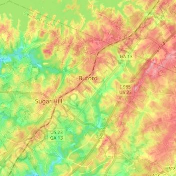
Name: Buford topographic map, elevation, terrain.
Location: Buford, Gwinnett County, Georgia, United States (34.06061 -84.04827 34.16851 -83.93922)
Average elevation: 1,115 ft
Minimum elevation: 935 ft
Maximum elevation: 1,289 ft
Buford is located in both northern Gwinnett County in northern Georgia, with a small portion extending north into Hall County. The city is a suburb within the Atlanta metropolitan area. According to the United States Census Bureau, as of 2010 the city has a total land area of 17.09 square miles (44.26 km2), of which 17.01 square miles (44.06 km2) is land and 0.08 square miles (0.20 km2), or 0.44%, is water. The city's elevation is 1,183 feet (361 m).
Other topographic maps
Click on a map to view its topography, its elevation and its terrain.
Suwanee
United States > Georgia > Gwinnett County
Suwanee, Gwinnett County, Georgia, United States
Average elevation: 1,020 ft
Lawrenceville
United States > Georgia > Gwinnett County
Lawrenceville, Gwinnett County, Georgia, United States
Average elevation: 1,024 ft
Rest Haven
United States > Georgia > Gwinnett County
Rest Haven, Gwinnett County, Georgia, United States
Average elevation: 1,145 ft
Berkeley Lake
United States > Georgia > Gwinnett County
Berkeley Lake, Gwinnett County, Georgia, United States
Average elevation: 1,020 ft
Mountain Park
United States > Georgia > Gwinnett County
Mountain Park, Gwinnett County, Georgia, 30047, United States
Average elevation: 958 ft
Myrdell Estates
United States > Georgia > Gwinnett County
Myrdell Estates, Gwinnett County, Georgia, 30519, United States
Average elevation: 1,165 ft
Duluth
United States > Georgia > Gwinnett County
Duluth, Gwinnett County, Georgia, United States
Average elevation: 1,001 ft
Oak Village
United States > Georgia > Gwinnett County
Oak Village, Gwinnett County, Georgia, 30043, United States
Average elevation: 1,037 ft
Lilburn
United States > Georgia > Gwinnett County
Lilburn, Gwinnett County, Georgia, United States
Average elevation: 955 ft
Sugar Hill
United States > Georgia > Gwinnett County
Sugar Hill, Gwinnett County, Georgia, United States
Average elevation: 1,089 ft
Peachtree Corners
United States > Georgia > Gwinnett County
Peachtree Corners, Gwinnett County, Georgia, 30092, United States
Average elevation: 994 ft
Grayson
United States > Georgia > Gwinnett County
Grayson, Gwinnett County, Georgia, United States
Average elevation: 1,047 ft
Berry Lake
United States > Georgia > Gwinnett County > Suwanee
Berry Lake, Suwanee, Gwinnett County, Georgia, United States
Average elevation: 997 ft
Dacula
United States > Georgia > Gwinnett County
Dacula, Gwinnett County, Georgia, United States
Average elevation: 1,027 ft
Duluth
United States > Georgia > Gwinnett County > Duluth
Duluth, Gwinnett County, Georgia, 30096, United States
Average elevation: 997 ft
Harbins Park
United States > Georgia > Gwinnett County
Harbins Park, Gwinnett County, Georgia, 30045-6560, United States
Average elevation: 889 ft
Settles Bridge
United States > Georgia > Gwinnett County > Suwanee > Settles Bridge
Settles Bridge, Suwanee, Gwinnett County, Georgia, 30024, United States
Average elevation: 1,030 ft
Rock Creek Estates
United States > Georgia > Gwinnett County > Buford > Rock Creek Estates
Rock Creek Estates, Buford, Gwinnett County, Georgia, 30519, United States
Average elevation: 1,109 ft
Snellville
United States > Georgia > Gwinnett County
Snellville, Gwinnett County, Georgia, United States
Average elevation: 984 ft
Norcross
United States > Georgia > Gwinnett County
Norcross, Gwinnett County, Georgia, 30071, United States
Average elevation: 1,014 ft