
Kamrup topographic map
Interactive map
Click on the map to display elevation.
About this map
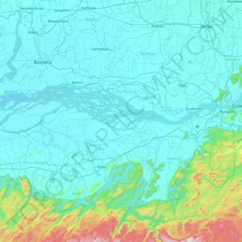
Name: Kamrup topographic map, elevation, terrain.
Location: Kamrup, Assam, India (25.72350 90.93766 26.56941 91.82193)
Average elevation: 459 ft
Minimum elevation: 102 ft
Maximum elevation: 3,963 ft
Other topographic maps
Click on a map to view its topography, its elevation and its terrain.
Barpeta Road
India > Assam > Barnagar (Pt)
Barpeta Road, Barnagar (Pt), Barpeta District, Assam, 781315, India
Average elevation: 151 ft
Barangajuli
India > Assam > Harisinga tehsil
Barangajuli, Harisinga tehsil, Udalguri District, Assam, 784526, India
Average elevation: 384 ft
North Lakhimpur
North Lakhimpur, Lakhimpur, Assam, India
Average elevation: 302 ft
Sarthebari
India > Assam > Sarthebari > Sarthebari
Sarthebari, Bajali, Assam, 781307, India
Average elevation: 135 ft
Jorhat
India > Assam > Jorhat East
Jorhat, Jorhat East, Jorhat, Assam, 785001, India
Average elevation: 305 ft
Dibrugarh West
India > Assam > Dibrugarh West
Dibrugarh West, Dibrugarh, Assam, India
Average elevation: 328 ft