
Cobden topographic map
Interactive map
Click on the map to display elevation.
About this map
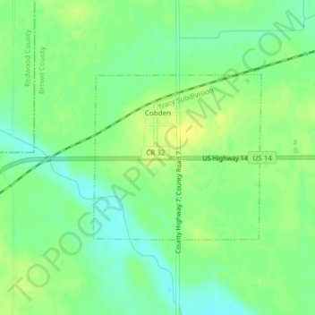
Name: Cobden topographic map, elevation, terrain.
Location: Cobden, Brown County, Minnesota, United States (44.27544 -94.85662 44.28963 -94.83647)
Average elevation: 1,027 ft
Minimum elevation: 991 ft
Maximum elevation: 1,056 ft
Other topographic maps
Click on a map to view its topography, its elevation and its terrain.
Sleepy Eye
United States > Minnesota > Brown County
Sleepy Eye, Brown County, Minnesota, United States
Average elevation: 1,017 ft
Hanska
United States > Minnesota > Brown County
Hanska, Brown County, Minnesota, United States
Average elevation: 1,010 ft
Springfield
United States > Minnesota > Brown County
Springfield, Brown County, Minnesota, United States
Average elevation: 1,053 ft
Evan
United States > Minnesota > Brown County
Evan, Brown County, Minnesota, United States
Average elevation: 1,027 ft
New Ulm
United States > Minnesota > Brown County
New Ulm, Brown County, Minnesota, 56073, United States
Average elevation: 912 ft
Comfrey
United States > Minnesota > Brown County
Comfrey, Brown County, Minnesota, United States
Average elevation: 1,129 ft