
Comfrey topographic map
Interactive map
Click on the map to display elevation.
About this map
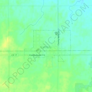
Name: Comfrey topographic map, elevation, terrain.
Location: Comfrey, Brown County, Minnesota, United States (44.10586 -94.91353 44.11514 -94.89467)
Average elevation: 1,129 ft
Minimum elevation: 1,099 ft
Maximum elevation: 1,161 ft
Other topographic maps
Click on a map to view its topography, its elevation and its terrain.
Sleepy Eye
United States > Minnesota > Brown County
Sleepy Eye, Brown County, Minnesota, United States
Average elevation: 1,017 ft
Hanska
United States > Minnesota > Brown County
Hanska, Brown County, Minnesota, United States
Average elevation: 1,010 ft
Springfield
United States > Minnesota > Brown County
Springfield, Brown County, Minnesota, United States
Average elevation: 1,053 ft
Evan
United States > Minnesota > Brown County
Evan, Brown County, Minnesota, United States
Average elevation: 1,027 ft
New Ulm
United States > Minnesota > Brown County
New Ulm, Brown County, Minnesota, 56073, United States
Average elevation: 912 ft
Cobden
United States > Minnesota > Brown County
Cobden, Brown County, Minnesota, United States
Average elevation: 1,027 ft