
Make a donation
Gear up for your next adventure:
As an Amazon Associate, this site earns from qualifying purchases at no extra cost to you.
Pop District topographic map
Click on the map to display elevation.
Make a donation
Gear up for your next adventure:
As an Amazon Associate, this site earns from qualifying purchases at no extra cost to you.
About this map
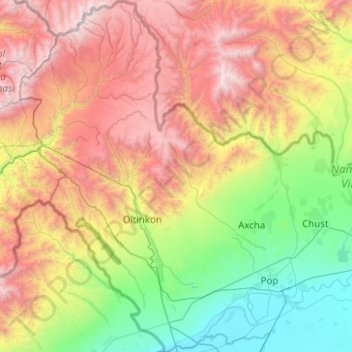
Name: Pop District topographic map, elevation, terrain.
Location: Pop District, Namangan Region, Uzbekistan (40.71982 70.38755 41.47187 71.28082)
Average elevation: 5,581 ft
Minimum elevation: 1,184 ft
Maximum elevation: 13,284 ft
Make a donation
Gear up for your next adventure:
As an Amazon Associate, this site earns from qualifying purchases at no extra cost to you.
Other topographic maps
Click on a map to view its topography, its elevation and its terrain.
Make a donation
Gear up for your next adventure:
As an Amazon Associate, this site earns from qualifying purchases at no extra cost to you.
Bukhara
Uzbekistan > Bukhara Region > Bukhara
About 140 miles (225 km) west of Samarkand in south-central Uzbekistan, Bukhara is located on the Zeravshan River, at an elevation of 751 feet (229 meters).
Average elevation: 738 ft
Make a donation
Gear up for your next adventure:
As an Amazon Associate, this site earns from qualifying purchases at no extra cost to you.
Make a donation
Gear up for your next adventure:
As an Amazon Associate, this site earns from qualifying purchases at no extra cost to you.