Geolocate

Nabón topographic map

Click on the map to display elevation.

About this map

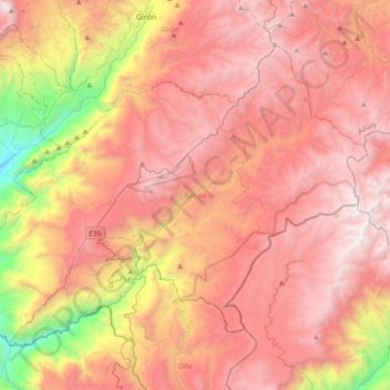
Name: Nabón topographic map, elevation, terrain.

Location: Nabón, Azuay, Ecuador (-3.47666 -79.30833 -3.18870 -78.93408)

Average elevation: 8,757 ft

Minimum elevation: 3,422 ft

Maximum elevation: 12,320 ft

Other topographic maps

Click on a map to view its topography, its elevation and its terrain.

Don Julo

Ecuador > Azuay > Guachapala > Guachapala

Average elevation: 7,717 ft

Cochapamba Grande

Ecuador > Azuay > Cuenca > Quingeo

Average elevation: 9,163 ft

Soldados

Ecuador > Azuay > Cuenca > San Joaquín

Average elevation: 11,719 ft

Lentag

Ecuador > Azuay > Girón

Average elevation: 4,931 ft

Ricaurte

Ecuador > Azuay > Cuenca > Cuenca > Ricaurte

Average elevation: 8,281 ft

Quebrada Limón

Ecuador > Azuay > Santa Isabel

Average elevation: 3,602 ft

Girón

Ecuador > Azuay > Girón

Average elevation: 7,976 ft

Gear up for your next adventure:

🛠️Outdoor Gear Repair Kit - Essential tools to fix gear on the trail
🪶Multi‑Purpose Knife - Useful blade for camp and trail
🪄Magnetic Compass - Accurate compass for navigation
🪑Ultralight Camp Chairs - Portable seating for resting after a long day of mapping
🏕️Tent Footprint - Protect your tent base from wear

As an Amazon Associate, this site earns from qualifying purchases at no extra cost to you.