Geolocate

Quito Canton topographic map

Click on the map to display elevation.

About this map

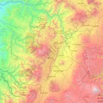
Name: Quito Canton topographic map, elevation, terrain.

Location: Quito Canton, Pichincha, Ecuador (-0.59568 -78.94768 0.25627 -78.16490)

Average elevation: 8,802 ft

Minimum elevation: 1,640 ft

Maximum elevation: 18,612 ft

Other topographic maps

Click on a map to view its topography, its elevation and its terrain.

Cayambe

Ecuador > Pichincha > Cayambe > Cayambe

Cayambe or Volcán Cayambe is a volcano in Ecuador, in the Cordillera Central, a range of the Ecuadorian Andes. It is located in Pichincha Province, some 70 km (43 mi) northeast of Quito. It is the third-highest mountain in Ecuador, at an elevation of 5,790 m (18,996 ft) above sea level.

Average elevation: 17,211 ft

Marianitas

Ecuador > Pichincha > Quito Canton > Nanegal

Average elevation: 4,390 ft

Santa Rosa

Ecuador > Pichincha > Quito Canton > Puembo

Average elevation: 7,900 ft

Calderón

Ecuador > Pichincha > Quito Canton

Average elevation: 8,340 ft

Pululahua

Ecuador > Pichincha > Quito Canton > Calacali

Average elevation: 9,035 ft

Tanlahua

Ecuador > Pichincha > Quito Canton > San Antonio

Average elevation: 8,520 ft

Frutillas

Ecuador > Pichincha > Quito Canton > Nono

Average elevation: 9,767 ft

La Concepcion

Ecuador > Pichincha > Quito Canton > Guayllabamba

Average elevation: 7,090 ft

Alaspungo

Ecuador > Pichincha > Quito Canton > Nono > Alaspungo

Average elevation: 9,039 ft

Ilaló

Ecuador > Pichincha > Quito Canton > Tumbaco

Average elevation: 9,629 ft

Volcán Cotopaxi

Ecuador > Pichincha > Machachi > Machachi

In the late 20th century, summiting Cotopaxi became a major tourist draw. The José F. Ribas Refuge (Refugio José Félix Ribas) was built in 1971 at an elevation of 4,864 m (15,960 ft) and enlarged in 2005.

Average elevation: 16,473 ft

San Rafael

Ecuador > Pichincha > Rumiñahui > Sangolquí > San Rafael

Average elevation: 8,323 ft

Carapungo

Ecuador > Pichincha > Quito Canton > Carapungo

Average elevation: 8,839 ft

Tandayapa

Ecuador > Pichincha > Quito Canton

Average elevation: 6,467 ft

Cachillacta

Ecuador > Pichincha > Quito Canton > Nanegal > Cachillacta

Average elevation: 4,514 ft

Zámbiza

Ecuador > Pichincha > Quito Canton

Average elevation: 8,625 ft

Gear up for your next adventure:

🪑Ultralight Camp Chairs - Portable seating for resting after a long day of mapping
🛡️Bear Spray Outdoor - Protection in bear country hikes
🪶Multi‑Purpose Knife - Useful blade for camp and trail
🔋Solar Power Banks - Keep your GPS and phone charged in remote wilderness areas
🚁Photography Drones - Capture stunning aerial views of landforms and topography

As an Amazon Associate, this site earns from qualifying purchases at no extra cost to you.