
Make a donation
Gear up for your next adventure:
As an Amazon Associate, this site earns from qualifying purchases at no extra cost to you.
Cheltenham Township topographic map
Click on the map to display elevation.
Make a donation
Gear up for your next adventure:
As an Amazon Associate, this site earns from qualifying purchases at no extra cost to you.
Cheltenham Township
According to the U.S. Census Bureau, the township has a total area of 9.0 square miles (23 km2), all land. The area consists of rolling hills and also features a few streams flowing through it, most notably the Tookany Creek. The highest elevation is 411 feet (125 m), at the intersection of Sunset and Lindley Roads. The lowest elevation is 63 feet (19 m), in the southeasternmost part of the township, where Tookany Creek flows into Philadelphia. It includes the census-designated places of Arcadia University, Glenside, and Wyncote. Other communities include Cheltenham, Elkins Park, Melrose Park, La Mott and Laverock, Edge Hill, and Cedarbrook. All of the communities form a border with Philadelphia along Cheltenham Avenue.
Make a donation
Gear up for your next adventure:
As an Amazon Associate, this site earns from qualifying purchases at no extra cost to you.
About this map
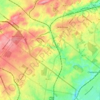
Name: Cheltenham Township topographic map, elevation, terrain.
Average elevation: 262 ft
Minimum elevation: 62 ft
Maximum elevation: 436 ft
Montgomery County trails, hiking, mountain biking, running and outdoor activities
Make a donation
Gear up for your next adventure:
As an Amazon Associate, this site earns from qualifying purchases at no extra cost to you.
Other topographic maps
Click on a map to view its topography, its elevation and its terrain.
Plymouth Meeting
United States > Pennsylvania > Montgomery County > Whitemarsh Township
Average elevation: 177 ft
Three Tuns
United States > Pennsylvania > Montgomery County > Upper Dublin Township > Maple Glen
Average elevation: 331 ft
Hidden Valley
United States > Pennsylvania > Montgomery County > Upper Merion Township
Average elevation: 154 ft
Marble Hall
United States > Pennsylvania > Montgomery County > Whitemarsh Township
Average elevation: 210 ft
Make a donation
Gear up for your next adventure:
As an Amazon Associate, this site earns from qualifying purchases at no extra cost to you.
Fagleysville
United States > Pennsylvania > Montgomery County > New Hanover Township
Average elevation: 344 ft
Woxall
United States > Pennsylvania > Montgomery County > Upper Salford Township
Average elevation: 322 ft
Fitzwatertown
United States > Pennsylvania > Montgomery County > Upper Dublin Township
Average elevation: 282 ft
Lafayette Hill
United States > Pennsylvania > Montgomery County > Whitemarsh Township
Average elevation: 194 ft
Make a donation
Gear up for your next adventure:
As an Amazon Associate, this site earns from qualifying purchases at no extra cost to you.
Limerick
United States > Pennsylvania > Montgomery County > Limerick Township
Average elevation: 282 ft
Huntingdon Valley
United States > Pennsylvania > Montgomery County > Lower Moreland Township
Average elevation: 213 ft
Ashmead Village
United States > Pennsylvania > Montgomery County > Cheltenham Township > Cheltenham
Average elevation: 167 ft
Gladwyne
United States > Pennsylvania > Montgomery County > Lower Merion Township
Average elevation: 302 ft
Make a donation
Gear up for your next adventure:
As an Amazon Associate, this site earns from qualifying purchases at no extra cost to you.
Mont Clare
United States > Pennsylvania > Montgomery County > Upper Providence Township
Average elevation: 184 ft
Evansburg State Park
United States > Pennsylvania > Montgomery County > Worcester Township > Cedars
Average elevation: 230 ft
Bala Cynwyd
United States > Pennsylvania > Montgomery County > Lower Merion Township
Average elevation: 249 ft
Penn Valley
United States > Pennsylvania > Montgomery County > Lower Merion Township > Ardmore
Average elevation: 292 ft
Make a donation
Gear up for your next adventure:
As an Amazon Associate, this site earns from qualifying purchases at no extra cost to you.
Elkins Park Gardens
United States > Pennsylvania > Montgomery County > Cheltenham Township > Cheltenham
Average elevation: 230 ft
Haverford
United States > Pennsylvania > Montgomery County > Lower Merion Township > Ardmore
Average elevation: 338 ft
Bryn Mawr
United States > Pennsylvania > Montgomery County > Lower Merion Township
Average elevation: 358 ft
Dresher
United States > Pennsylvania > Montgomery County > Upper Dublin Township
Average elevation: 269 ft
Make a donation
Gear up for your next adventure:
As an Amazon Associate, this site earns from qualifying purchases at no extra cost to you.
La Mott Community Center & Playground
United States > Pennsylvania > Montgomery County > Cheltenham Township > Lamott
Average elevation: 253 ft
Arlingham
United States > Pennsylvania > Montgomery County > Springfield Township
Average elevation: 217 ft
Hamilton Court
United States > Pennsylvania > Montgomery County > Lower Merion Township > Ardmore
Average elevation: 335 ft
Upper Glasgow
United States > Pennsylvania > Montgomery County > West Pottsgrove Township
Average elevation: 282 ft
Make a donation
Gear up for your next adventure:
As an Amazon Associate, this site earns from qualifying purchases at no extra cost to you.
Gladwyne
United States > Pennsylvania > Montgomery County > Lower Merion Township
Average elevation: 302 ft
Edge Hill
United States > Pennsylvania > Montgomery County > Cheltenham Township > Glenside
Average elevation: 308 ft
Brandywine Village
United States > Pennsylvania > Montgomery County > Upper Merion Township
Average elevation: 164 ft
Make a donation
Gear up for your next adventure:
As an Amazon Associate, this site earns from qualifying purchases at no extra cost to you.
Franklinville
United States > Pennsylvania > Montgomery County > Whitpain Township
Average elevation: 308 ft
Gwynedd Valley
United States > Pennsylvania > Montgomery County > Lower Gwynedd Township
Average elevation: 305 ft
Gladwyne
United States > Pennsylvania > Montgomery County > Lower Merion Township
Average elevation: 302 ft
Huntingdon Valley
United States > Pennsylvania > Montgomery County > Lower Moreland Township
Average elevation: 213 ft
Make a donation
Gear up for your next adventure:
As an Amazon Associate, this site earns from qualifying purchases at no extra cost to you.
Jeffersonville
United States > Pennsylvania > Montgomery County > West Norriton Township
Average elevation: 184 ft
Cedars
United States > Pennsylvania > Montgomery County > Worcester Township
Average elevation: 230 ft
Morganville
United States > Pennsylvania > Montgomery County > Upper Moreland Township > Willow Grove
Average elevation: 266 ft
Make a donation
Gear up for your next adventure:
As an Amazon Associate, this site earns from qualifying purchases at no extra cost to you.
Rydal Park
United States > Pennsylvania > Montgomery County > Abington Township
Average elevation: 285 ft
Penn Wynne
United States > Pennsylvania > Montgomery County > Lower Merion Township
Average elevation: 249 ft
Lafayette Hill
United States > Pennsylvania > Montgomery County > Whitemarsh Township
Average elevation: 194 ft
Betzwood
United States > Pennsylvania > Montgomery County > West Norriton Township
Average elevation: 157 ft
Make a donation
Gear up for your next adventure:
As an Amazon Associate, this site earns from qualifying purchases at no extra cost to you.
Mainland
United States > Pennsylvania > Montgomery County > Lower Salford Township
Average elevation: 259 ft
Penllyn
United States > Pennsylvania > Montgomery County > Lower Gwynedd Township
Average elevation: 279 ft
Willow Grove
United States > Pennsylvania > Montgomery County > Upper Moreland Township
Average elevation: 299 ft
Bala Cynwyd
United States > Pennsylvania > Montgomery County > Lower Merion Township
Average elevation: 246 ft
Make a donation
Gear up for your next adventure:
As an Amazon Associate, this site earns from qualifying purchases at no extra cost to you.
Unami Creek
United States > Pennsylvania > Montgomery County > Marlborough Township
Average elevation: 410 ft
Wynmere Downs
United States > Pennsylvania > Montgomery County > Horsham Township
Average elevation: 322 ft
Eagleville
United States > Pennsylvania > Montgomery County > Lower Providence Township
Average elevation: 335 ft
Belmont Terrace
United States > Pennsylvania > Montgomery County > Upper Merion Township > King of Prussia
Average elevation: 148 ft
Make a donation
Gear up for your next adventure:
As an Amazon Associate, this site earns from qualifying purchases at no extra cost to you.
Gwynedd
United States > Pennsylvania > Montgomery County > Lower Gwynedd Township
Average elevation: 364 ft
New Hanover
United States > Pennsylvania > Montgomery County > New Hanover Township
Average elevation: 299 ft
Elkins Park Gardens
United States > Pennsylvania > Montgomery County > Cheltenham Township > Cheltenham
Average elevation: 230 ft
Make a donation
Gear up for your next adventure:
As an Amazon Associate, this site earns from qualifying purchases at no extra cost to you.
Oreland
United States > Pennsylvania > Montgomery County > Upper Dublin Township
Average elevation: 262 ft
Lafayette Park
United States > Pennsylvania > Montgomery County > King of Prussia > Lafayette Park
Average elevation: 177 ft
Ashbourne
United States > Pennsylvania > Montgomery County > Cheltenham Township
Average elevation: 230 ft
Albidale
United States > Pennsylvania > Montgomery County > Lower Moreland Township > Albidale
Average elevation: 253 ft
Make a donation
Gear up for your next adventure:
As an Amazon Associate, this site earns from qualifying purchases at no extra cost to you.
Mount Joy
United States > Pennsylvania > Montgomery County > Upper Merion Township
Average elevation: 226 ft
Haverford
United States > Pennsylvania > Montgomery County > Lower Merion Township > Ardmore
Average elevation: 338 ft
Mainland
United States > Pennsylvania > Montgomery County > Lower Salford Township
Average elevation: 259 ft
Village of Mingo
United States > Pennsylvania > Montgomery County > Upper Providence Township
Average elevation: 230 ft
Make a donation
Gear up for your next adventure:
As an Amazon Associate, this site earns from qualifying purchases at no extra cost to you.
Bergey
United States > Pennsylvania > Montgomery County > Upper Salford Township
Average elevation: 305 ft
Palm
United States > Pennsylvania > Montgomery County > Upper Hanover Township
Average elevation: 430 ft