Geolocate

Nazareth topographic map

Click on the map to display elevation.

About this map

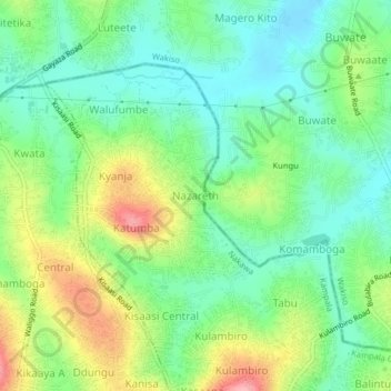
Name: Nazareth topographic map, elevation, terrain.

Location: Nazareth, Kampala, Central Region, Uganda (0.37227 32.58419 0.41227 32.62419)

Average elevation: 3,862 ft

Minimum elevation: 3,720 ft

Maximum elevation: 4,121 ft

Other topographic maps

Click on a map to view its topography, its elevation and its terrain.

Rubaga

Uganda > Central Region > Kampala

Average elevation: 3,894 ft

Nakawa

Uganda > Central Region > Kampala

Average elevation: 3,865 ft

Central

Uganda > Central Region > Kampala

Average elevation: 3,914 ft

1p

Uganda > Central Region > Kampala

Average elevation: 3,881 ft

Gear up for your next adventure:

🥇GPS Hiking Watch - Multi‑sport GPS watch with navigation and trail tracking
🎒Trail Energy Bars - High‑calorie bars for hiking energy
🥾Men's Hiking Boots - Durable, waterproof footwear for rugged terrain and steep inclines
🥾Women's Hiking Boots - Top-rated trail boots with ankle support and superior grip
⛑️Personal Locator Beacon - Safety beacon for emergencies

As an Amazon Associate, this site earns from qualifying purchases at no extra cost to you.