Geolocate

Rubaga topographic map

Click on the map to display elevation.

About this map

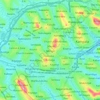
Name: Rubaga topographic map, elevation, terrain.

Location: Rubaga, Kampala, Central Region, Uganda (0.27082 32.50988 0.35101 32.57710)

Average elevation: 3,894 ft

Minimum elevation: 3,757 ft

Maximum elevation: 4,298 ft

Other topographic maps

Click on a map to view its topography, its elevation and its terrain.

Kigoowa I

Uganda > Central Region > Kampala

Average elevation: 3,917 ft

Pepsi

Uganda > Central Region > Kampala

Average elevation: 3,842 ft

1p

Uganda > Central Region > Kampala

Average elevation: 3,881 ft

Universal

Uganda > Central Region > Kampala

Average elevation: 3,885 ft

Nazareth

Uganda > Central Region > Kampala

Average elevation: 3,862 ft

Boston

Uganda > Central Region > Kampala > Boston

Average elevation: 3,878 ft

K 2

Uganda > Central Region > Kampala

Average elevation: 3,914 ft

Utc

Uganda > Central Region > Kampala > Utc

Average elevation: 3,898 ft

Gear up for your next adventure:

🔌USB Car Charger - Car charger for on‑the‑go power needs
🛡️Insect Repellent - Protection against bugs during outdoor activities
📱Solar Portable Charger - Solar power bank for charging devices off‑grid
🏫Relief Map Kits - Hands-on tools for teaching landforms and elevation
🧥Men's Rain Shells - Premium waterproof and breathable jackets for mountain weather

As an Amazon Associate, this site earns from qualifying purchases at no extra cost to you.