Geolocate

1p topographic map

Click on the map to display elevation.

About this map

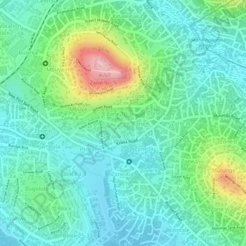
Name: 1p topographic map, elevation, terrain.

Location: 1p, Nakawa, Kampala, Central Region, Uganda (0.32102 32.63139 0.32109 32.63166)

Average elevation: 3,881 ft

Minimum elevation: 3,717 ft

Maximum elevation: 4,288 ft

Other topographic maps

Click on a map to view its topography, its elevation and its terrain.

Rubaga

Uganda > Central Region > Kampala

Average elevation: 3,894 ft

Nakawa

Uganda > Central Region > Kampala

Average elevation: 3,865 ft

Kigoowa I

Uganda > Central Region > Kampala

Average elevation: 3,917 ft

Pepsi

Uganda > Central Region > Kampala

Average elevation: 3,842 ft

Universal

Uganda > Central Region > Kampala

Average elevation: 3,885 ft

Nazareth

Uganda > Central Region > Kampala

Average elevation: 3,862 ft

Boston

Uganda > Central Region > Kampala > Boston

Average elevation: 3,878 ft

K 2

Uganda > Central Region > Kampala

Average elevation: 3,914 ft

Utc

Uganda > Central Region > Kampala > Utc

Average elevation: 3,898 ft

Central

Uganda > Central Region > Kampala

Average elevation: 3,914 ft

Gear up for your next adventure:

🦶Hiking Gaiters - Keep debris and water out of your boots
📖Nature Tracking Books - Learn to track wildlife and terrain
🧢Sun Protection Hats - Wide-brimmed and UPF-rated hats for high-altitude sun safety
🧤Tactile Hiking Gloves - Keep hands warm while operating GPS and smartphone screens
🦺Reflective Outdoor Gear - Safety gear for low‑light conditions

As an Amazon Associate, this site earns from qualifying purchases at no extra cost to you.