Geolocate

Central topographic map

Click on the map to display elevation.

About this map

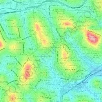
Name: Central topographic map, elevation, terrain.

Location: Central, Kampala, Central Region, Uganda (0.30345 32.55964 0.35052 32.61191)

Average elevation: 3,914 ft

Minimum elevation: 3,753 ft

Maximum elevation: 4,268 ft

Other topographic maps

Click on a map to view its topography, its elevation and its terrain.

Kigoowa I

Uganda > Central Region > Kampala

Average elevation: 3,917 ft

Pepsi

Uganda > Central Region > Kampala

Average elevation: 3,842 ft

1p

Uganda > Central Region > Kampala

Average elevation: 3,881 ft

Universal

Uganda > Central Region > Kampala

Average elevation: 3,885 ft

Nazareth

Uganda > Central Region > Kampala

Average elevation: 3,862 ft

Boston

Uganda > Central Region > Kampala > Boston

Average elevation: 3,878 ft

K 2

Uganda > Central Region > Kampala

Average elevation: 3,914 ft

Utc

Uganda > Central Region > Kampala > Utc

Average elevation: 3,898 ft

Gear up for your next adventure:

🧺Microfiber Travel Towels - Compact and fast-drying towels for trail use
🦶Hiking Gaiters - Keep debris and water out of your boots
🪶Fire Starter Kit - Reliable fire starter for survival and camping
🪶Camping Sleeping Pad - Comfortable sleeping pad for backpacking
🪶Trail Camera - Capture wildlife on your hikes

As an Amazon Associate, this site earns from qualifying purchases at no extra cost to you.