Geolocate

Nakawa topographic map

Click on the map to display elevation.

About this map

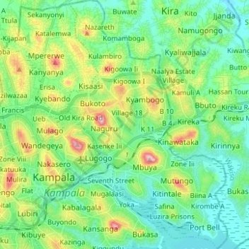
Name: Nakawa topographic map, elevation, terrain.

Location: Nakawa, Kampala, Central Region, Uganda (0.28207 32.58561 0.40577 32.66768)

Average elevation: 3,865 ft

Minimum elevation: 3,698 ft

Maximum elevation: 4,291 ft

Other topographic maps

Click on a map to view its topography, its elevation and its terrain.

Kigoowa I

Uganda > Central Region > Kampala

Average elevation: 3,917 ft

Pepsi

Uganda > Central Region > Kampala

Average elevation: 3,842 ft

1p

Uganda > Central Region > Kampala

Average elevation: 3,881 ft

Universal

Uganda > Central Region > Kampala

Average elevation: 3,885 ft

Nazareth

Uganda > Central Region > Kampala

Average elevation: 3,862 ft

Boston

Uganda > Central Region > Kampala > Boston

Average elevation: 3,878 ft

K 2

Uganda > Central Region > Kampala

Average elevation: 3,914 ft

Utc

Uganda > Central Region > Kampala > Utc

Average elevation: 3,898 ft

Gear up for your next adventure:

🧯Emergency Survival Kit - All‑in‑one survival essentials for the backcountry
🏥Hiking First Aid Kits - Comprehensive medical kits for remote trail injuries
🦶Hiking Gaiters - Keep debris and water out of your boots
🗺️NatGeo Topo Maps - High-quality waterproof printed topographic maps of US Parks
🪶Compact Camp Shovel - Folding shovel for campsite tasks

As an Amazon Associate, this site earns from qualifying purchases at no extra cost to you.