
Make a donation
Gear up for your next adventure:
As an Amazon Associate, this site earns from qualifying purchases at no extra cost to you.
Caloosahatchee River topographic map
Click on the map to display elevation.
Make a donation
Gear up for your next adventure:
As an Amazon Associate, this site earns from qualifying purchases at no extra cost to you.
Caloosahatchee River
Until late in the 19th century, the Caloosahatchee River was fed by a series of lakes starting from Lake Hicpochee, and including Lettuce Lake, Bonnet Lake and Flirt Lake. A waterfall and set of rapids at the lower end of Flirt Lake marked the beginning of the river. The rapids were close to 1 mile (1.6 km) long, with a drop in elevation of about 10 feet (3.0 m). Lake Hicpochee, about 9,000 acres (3,600 ha) in area, was only 3 miles (4.8 km) from Lake Okeechobee, but there was no connection between the two lakes before the late 19th century. Water flowed from Lake Hicpochee westward into Lettuce Lake and then Bonnet Lake. When the water was high, the two lakes merged. From Bonnet Lake, water flowed into Lake Flirt, which was about 1,000 acres (400 ha) in area and 5 miles (8.0 km) long. All of the lakes were surrounded by extensive wetlands.
Make a donation
Gear up for your next adventure:
As an Amazon Associate, this site earns from qualifying purchases at no extra cost to you.
About this map
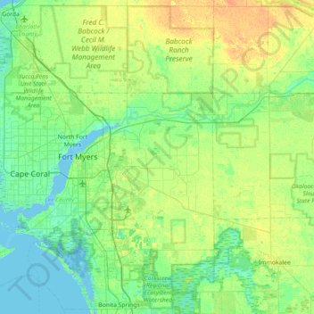
Name: Caloosahatchee River topographic map, elevation, terrain.
Location: Caloosahatchee River, Lee County, Florida, United States (26.47910 -82.01771 26.79808 -81.30518)
Average elevation: 26 ft
Minimum elevation: -3 ft
Maximum elevation: 79 ft
Lee County trails, hiking, mountain biking, running and outdoor activities
Make a donation
Gear up for your next adventure:
As an Amazon Associate, this site earns from qualifying purchases at no extra cost to you.
Other topographic maps
Click on a map to view its topography, its elevation and its terrain.
Saint James Mobile Home Park
United States > Florida > Lee County > Saint James City
Average elevation: 3 ft
Make a donation
Gear up for your next adventure:
As an Amazon Associate, this site earns from qualifying purchases at no extra cost to you.
North Shore Park
United States > Florida > Lee County > North Fort Myers > Sunset North Condominiums
Average elevation: 3 ft
Make a donation
Gear up for your next adventure:
As an Amazon Associate, this site earns from qualifying purchases at no extra cost to you.
Riverbend Golf and River Club
United States > Florida > Lee County > North Fort Myers
Average elevation: 10 ft
Make a donation
Gear up for your next adventure:
As an Amazon Associate, this site earns from qualifying purchases at no extra cost to you.
Bonita National Golf & Country Club
United States > Florida > Lee County > Bonita Springs
Average elevation: 16 ft
Make a donation
Gear up for your next adventure:
As an Amazon Associate, this site earns from qualifying purchases at no extra cost to you.
Make a donation
Gear up for your next adventure:
As an Amazon Associate, this site earns from qualifying purchases at no extra cost to you.
Pine Island Center
United States > Florida > Lee County > Blue Crab Key Condos
Average elevation: 10 ft
Make a donation
Gear up for your next adventure:
As an Amazon Associate, this site earns from qualifying purchases at no extra cost to you.
Spring Creek Village
United States > Florida > Lee County > Bonita Springs > Pelican Landing
Average elevation: 13 ft
Make a donation
Gear up for your next adventure:
As an Amazon Associate, this site earns from qualifying purchases at no extra cost to you.
Make a donation
Gear up for your next adventure:
As an Amazon Associate, this site earns from qualifying purchases at no extra cost to you.
Herons Glen Golf and Country Club
United States > Florida > Lee County > Herons Glen Golf and Country Club
Average elevation: 26 ft
Make a donation
Gear up for your next adventure:
As an Amazon Associate, this site earns from qualifying purchases at no extra cost to you.
Make a donation
Gear up for your next adventure:
As an Amazon Associate, this site earns from qualifying purchases at no extra cost to you.
Make a donation
Gear up for your next adventure:
As an Amazon Associate, this site earns from qualifying purchases at no extra cost to you.
Make a donation
Gear up for your next adventure:
As an Amazon Associate, this site earns from qualifying purchases at no extra cost to you.
Make a donation
Gear up for your next adventure:
As an Amazon Associate, this site earns from qualifying purchases at no extra cost to you.
Make a donation
Gear up for your next adventure:
As an Amazon Associate, this site earns from qualifying purchases at no extra cost to you.
Highland Woods Golf & Country Club
United States > Florida > Lee County > Bonita Springs
Average elevation: 16 ft
Make a donation
Gear up for your next adventure:
As an Amazon Associate, this site earns from qualifying purchases at no extra cost to you.
Carmel at Vanderbilt Lakes
United States > Florida > Lee County > Bonita Springs
Average elevation: 16 ft
Coconut Shores
United States > Florida > Lee County > The Colony Golf & Bay Club
Average elevation: 20 ft
Make a donation
Gear up for your next adventure:
As an Amazon Associate, this site earns from qualifying purchases at no extra cost to you.
Make a donation
Gear up for your next adventure:
As an Amazon Associate, this site earns from qualifying purchases at no extra cost to you.
Swan Lake Travel Trailer Park
United States > Florida > Lee County > North Fort Myers
Average elevation: 20 ft
Palm Frond Condominiums
United States > Florida > Lee County > North Fort Myers
Average elevation: 10 ft
Worthington Country Club
United States > Florida > Lee County > Bonita Springs
Average elevation: 20 ft
Make a donation
Gear up for your next adventure:
As an Amazon Associate, this site earns from qualifying purchases at no extra cost to you.
Make a donation
Gear up for your next adventure:
As an Amazon Associate, this site earns from qualifying purchases at no extra cost to you.
Pioneer Village RV Resort & Resort Community
United States > Florida > Lee County > North Fort Myers
Average elevation: 13 ft
Make a donation
Gear up for your next adventure:
As an Amazon Associate, this site earns from qualifying purchases at no extra cost to you.
Pine Shadows Air Park
United States > Florida > Lee County > Pine Shadows Air Park
Average elevation: 26 ft
Make a donation
Gear up for your next adventure:
As an Amazon Associate, this site earns from qualifying purchases at no extra cost to you.
Make a donation
Gear up for your next adventure:
As an Amazon Associate, this site earns from qualifying purchases at no extra cost to you.
Six Lakes Country Club
United States > Florida > Lee County > North Fort Myers > Six Lakes Country Club
Average elevation: 16 ft
Make a donation
Gear up for your next adventure:
As an Amazon Associate, this site earns from qualifying purchases at no extra cost to you.
Residences at Coconut Point
United States > Florida > Lee County > Shadow Wood
Average elevation: 20 ft
Rapallo at Coconut Point
United States > Florida > Lee County > Shadow Wood > Rapallo at Coconut Point
Average elevation: 20 ft
Make a donation
Gear up for your next adventure:
As an Amazon Associate, this site earns from qualifying purchases at no extra cost to you.
Make a donation
Gear up for your next adventure:
As an Amazon Associate, this site earns from qualifying purchases at no extra cost to you.