
Make a donation
Gear up for your next adventure:
As an Amazon Associate, this site earns from qualifying purchases at no extra cost to you.
Strandebarm topographic map
Click on the map to display elevation.
Make a donation
Gear up for your next adventure:
As an Amazon Associate, this site earns from qualifying purchases at no extra cost to you.
About this map
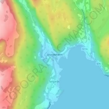
Name: Strandebarm topographic map, elevation, terrain.
Location: Strandebarm, Kvam herad, Vestland, 5630, Norwegen (60.25089 5.99152 60.29089 6.03152)
Average elevation: 594 ft
Minimum elevation: -3 ft
Maximum elevation: 1,965 ft
Make a donation
Gear up for your next adventure:
As an Amazon Associate, this site earns from qualifying purchases at no extra cost to you.
Other topographic maps
Click on a map to view its topography, its elevation and its terrain.
Make a donation
Gear up for your next adventure:
As an Amazon Associate, this site earns from qualifying purchases at no extra cost to you.
Bergen
Bergen ist eine Hafenstadt und liegt am inneren Byfjord an der Westküste Norwegens. Die Stadt wird auch als „Tor zu den Fjorden“ bezeichnet. Die Erhebung Gullfjelltoppen stellt mit einer Höhe von 987,44 moh. den höchsten Punkt der Kommune Bergen dar.
Average elevation: 410 ft
Make a donation
Gear up for your next adventure:
As an Amazon Associate, this site earns from qualifying purchases at no extra cost to you.
Askvoll
Askvoll ist eine Kommune in Sunnfjord in der Provinz Vestland in Norwegen. Sie liegt direkt am Atlantik. Die Kommune hat eine Fläche von 326 km² und hat 2930 Einwohner (Stand 1. Januar 2025). Verwaltet wird die Kommune von dem Ort Askvoll aus. Die höchste Erhebung ist der Blægja mit einer Höhe von 1304 Metern.
Average elevation: 167 ft
Make a donation
Gear up for your next adventure:
As an Amazon Associate, this site earns from qualifying purchases at no extra cost to you.
Make a donation
Gear up for your next adventure:
As an Amazon Associate, this site earns from qualifying purchases at no extra cost to you.
Make a donation
Gear up for your next adventure:
As an Amazon Associate, this site earns from qualifying purchases at no extra cost to you.
Make a donation
Gear up for your next adventure:
As an Amazon Associate, this site earns from qualifying purchases at no extra cost to you.
Make a donation
Gear up for your next adventure:
As an Amazon Associate, this site earns from qualifying purchases at no extra cost to you.
Make a donation
Gear up for your next adventure:
As an Amazon Associate, this site earns from qualifying purchases at no extra cost to you.
Make a donation
Gear up for your next adventure:
As an Amazon Associate, this site earns from qualifying purchases at no extra cost to you.
Gloppen
Das Terrain von Gloppen ist größtenteils bergig mit nur eher kleineren zusammenhängenden Gegenden, die tiefer liegen. Höchste Erhebung ist der Snønipa an der Grenze zur Gemeinde Sunnfjord mit einer Höhe von 1826,8 moh.[2] In der Kommune liegen drei größere Gletscher, der Myklebustbreen, der Ålfotbreen…
Average elevation: 1,988 ft
Make a donation
Gear up for your next adventure:
As an Amazon Associate, this site earns from qualifying purchases at no extra cost to you.
Make a donation
Gear up for your next adventure:
As an Amazon Associate, this site earns from qualifying purchases at no extra cost to you.