
Lumpkin County topographic map
Interactive map
Click on the map to display elevation.
About this map
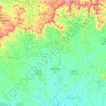
Name: Lumpkin County topographic map, elevation, terrain.
Location: Lumpkin County, Georgia, United States (34.41839 -84.19096 34.74110 -83.83153)
Average elevation: 1,818 ft
Minimum elevation: 1,060 ft
Maximum elevation: 4,364 ft
Other topographic maps
Click on a map to view its topography, its elevation and its terrain.
Atlanta
United States > Georgia > Fulton County
Atlanta, Fulton County, Georgia, United States
Average elevation: 932 ft
Augusta
United States > Georgia > Augusta
Augusta, Richmond County, Georgia, 30901, United States
Average elevation: 295 ft
Athens
United States > Georgia > Athens
Athens, Athens-Clarke County, Georgia, 303341458, United States
Average elevation: 725 ft
Savannah
United States > Georgia > Chatham County
Savannah, Chatham County, Georgia, United States
Average elevation: 13 ft
Atlanta
United States > Georgia > Fulton County
Atlanta, Fulton County, Georgia, 30303, United States
Average elevation: 935 ft
Dahlonega
United States > Georgia > Lumpkin County
Dahlonega, Lumpkin County, Georgia, United States
Average elevation: 1,348 ft
Vinings
United States > Georgia > Cobb County
Vinings, Cobb County, Georgia, 30339, United States
Average elevation: 922 ft
Wilscot
United States > Georgia > Fannin County
Wilscot, Fannin County, Georgia, United States
Average elevation: 2,014 ft
Carroll County
Carroll County, Georgia, United States
Average elevation: 1,066 ft
Helen
United States > Georgia > White County
Helen, White County, Georgia, 30545, United States
Average elevation: 1,601 ft
Ellijay
United States > Georgia > Gilmer County
Ellijay, Gilmer County, Georgia, 30540, United States
Average elevation: 1,391 ft
Blue Ridge
United States > Georgia > Fannin County
Blue Ridge, Fannin County, Georgia, United States
Average elevation: 1,755 ft
Tybee Island
United States > Georgia > Chatham County
Tybee Island, Chatham County, Georgia, 31328, United States
Average elevation: 3 ft
Gwinnett County
Gwinnett County, Georgia, United States
Average elevation: 991 ft
Brunswick
United States > Georgia > Glynn County
Brunswick, Glynn County, Georgia, United States
Average elevation: 7 ft
Robins Air Force Base
United States > Georgia > Houston County
Robins Air Force Base, Houston County, Georgia, 31098, United States
Average elevation: 302 ft
Georgia International Horse Park
United States > Georgia > Rockdale County > Conyers
Georgia International Horse Park, Conyers, Rockdale County, Georgia, United States
Average elevation: 686 ft
Alpharetta
United States > Georgia > Fulton County
Alpharetta, Fulton County, Georgia, United States
Average elevation: 1,063 ft
Saint Simons Island
United States > Georgia > Glynn County
Saint Simons Island, Glynn County, Georgia, 31561, United States
Average elevation: 7 ft
Macon
United States > Georgia > Bibb County
Macon, Bibb County, Georgia, United States
Average elevation: 417 ft
Columbus
United States > Georgia > Muscogee County
Columbus, Muscogee County, Georgia, United States
Average elevation: 427 ft
Hiawassee
United States > Georgia > Towns County
Hiawassee, Towns County, Georgia, United States
Average elevation: 2,034 ft
Gainesville
United States > Georgia > Hall County
Gainesville, Hall County, Georgia, 30501, United States
Average elevation: 1,135 ft
Blairsville
United States > Georgia > Union County
Blairsville, Union County, Georgia, United States
Average elevation: 1,926 ft
Skidaway Island
United States > Georgia > Chatham County
Skidaway Island, Chatham County, Georgia, 31411, United States
Average elevation: 10 ft
Fannin County
Fannin County, Georgia, United States
Average elevation: 2,060 ft
Lumpkin
United States > Georgia > Stewart County
Lumpkin, Stewart County, Georgia, United States
Average elevation: 482 ft
Canton
United States > Georgia > Cherokee County
Canton, Cherokee County, Georgia, United States
Average elevation: 1,050 ft
Jointer Island
United States > Georgia > Glynn County > Brunswick
Jointer Island, Brunswick, Glynn County, Georgia, United States
Average elevation: 0 ft
Forsyth County
Forsyth County, Georgia, United States
Average elevation: 1,129 ft
Heritage Acres
United States > Georgia > Bibb County > Macon
Heritage Acres, Macon, Bibb County, Georgia, 31211, United States
Average elevation: 390 ft
Stone Mountain
United States > Georgia > DeKalb County
Stone Mountain, DeKalb County, Georgia, 30087, United States
Average elevation: 981 ft
Woodstock
United States > Georgia > Cherokee County
Woodstock, Cherokee County, Georgia, United States
Average elevation: 971 ft
Lake Oconee
United States > Georgia > Greene County > Lake Oconee
Lake Oconee, Greene County, Georgia, United States
Average elevation: 541 ft
Mountain City
United States > Georgia > Rabun County
Mountain City, Rabun County, Georgia, 30562, United States
Average elevation: 2,451 ft
Kennesaw
United States > Georgia > Cobb County
Kennesaw, Cobb County, Georgia, 30144, United States
Average elevation: 1,040 ft
Iron Mountain
United States > Georgia > Murray County
Iron Mountain, Murray County, Georgia, United States
Average elevation: 1,188 ft
Fort Pulaski
United States > Georgia > Chatham County
Fort Pulaski, Fort Perimeter Trail, Chatham County, Georgia, 31328, United States
Average elevation: 3 ft
Tugaloo
United States > Georgia > Habersham County > Tallulah Falls
Tugaloo, Tallulah Falls, Habersham County, Georgia, United States
Average elevation: 1,286 ft
Elmodel
United States > Georgia > Baker County
Elmodel, Baker County, Georgia, United States
Average elevation: 167 ft
Leary
United States > Georgia > Calhoun County
Leary, Calhoun County, Georgia, 39862, United States
Average elevation: 200 ft
Paulding County
Paulding County, Georgia, United States
Average elevation: 1,020 ft
Warner Robins
United States > Georgia > Houston County
Warner Robins, Houston County, Georgia, United States
Average elevation: 331 ft