
Make a donation
Gear up for your next adventure:
As an Amazon Associate, this site earns from qualifying purchases at no extra cost to you.
Metchosin topographic map
Click on the map to display elevation.
Make a donation
Gear up for your next adventure:
As an Amazon Associate, this site earns from qualifying purchases at no extra cost to you.
About this map
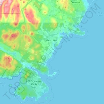
Name: Metchosin topographic map, elevation, terrain.
Average elevation: 194 ft
Minimum elevation: -3 ft
Maximum elevation: 1,257 ft
Make a donation
Gear up for your next adventure:
As an Amazon Associate, this site earns from qualifying purchases at no extra cost to you.
Other topographic maps
Click on a map to view its topography, its elevation and its terrain.
Japan Gulch Reservoir
Canada > British Columbia > Capital Regional District > Juan de Fuca Electoral Area
Average elevation: 899 ft
Saanich
Canada > British Columbia > Capital Regional District > Saanich > Saanich
Average elevation: 105 ft
Lone Tree Hill
Canada > British Columbia > Capital Regional District > Highlands
Average elevation: 751 ft
Mount Douglas
Canada > British Columbia > Capital Regional District > Saanich
Average elevation: 154 ft
Make a donation
Gear up for your next adventure:
As an Amazon Associate, this site earns from qualifying purchases at no extra cost to you.
Port Renfrew
Canada > British Columbia > Capital Regional District > Juan de Fuca Electoral Area
Average elevation: 256 ft
Leechtown
Canada > British Columbia > Capital Regional District > Juan de Fuca Electoral Area
Average elevation: 778 ft
San Juan River
Canada > British Columbia > Capital Regional District > Juan de Fuca Electoral Area
Average elevation: 121 ft
Shirley
Canada > British Columbia > Capital Regional District > Juan de Fuca Electoral Area
Average elevation: 259 ft
Make a donation
Gear up for your next adventure:
As an Amazon Associate, this site earns from qualifying purchases at no extra cost to you.
San Juan Ridge
Canada > British Columbia > Capital Regional District > Juan de Fuca Electoral Area
Average elevation: 2,759 ft
Saanich Peninsula
Canada > British Columbia > Capital Regional District > Central Saanich
Average elevation: 161 ft
Ganges
Canada > British Columbia > Capital Regional District > Salt Spring Island Electoral Area
Average elevation: 371 ft
Make a donation
Gear up for your next adventure:
As an Amazon Associate, this site earns from qualifying purchases at no extra cost to you.
Esquimalt
Canada > British Columbia > Capital Regional District > Esquimalt > Esquimalt
Average elevation: 46 ft
Mount Tolmie
Canada > British Columbia > Capital Regional District > Saanich
Average elevation: 171 ft
View Royal
Canada > British Columbia > Capital Regional District > View Royal > View Royal
Average elevation: 112 ft
Fulford Harbour
Canada > British Columbia > Capital Regional District > Salt Spring Island Electoral Area
Average elevation: 361 ft
Make a donation
Gear up for your next adventure:
As an Amazon Associate, this site earns from qualifying purchases at no extra cost to you.
Triangular Hill
Canada > British Columbia > Capital Regional District > Colwood
Average elevation: 354 ft
PKOLS (Mount Douglas)
Canada > British Columbia > Capital Regional District > Saanich
Average elevation: 154 ft
Mount Finlayson
Canada > British Columbia > Capital Regional District > Langford
Average elevation: 518 ft
Mayne
Canada > British Columbia > Capital Regional District > Southern Gulf Islands Electoral Area
Average elevation: 171 ft
Make a donation
Gear up for your next adventure:
As an Amazon Associate, this site earns from qualifying purchases at no extra cost to you.
Goldstream River
Canada > British Columbia > Capital Regional District > Juan de Fuca Electoral Area
Average elevation: 810 ft
Cecelia Creek Falls Park
Canada > British Columbia > Capital Regional District > Saanich
Average elevation: 118 ft
Mount Parke
Canada > British Columbia > Capital Regional District > Southern Gulf Islands Electoral Area
Average elevation: 243 ft
Abraham Collins' Lookout
Canada > British Columbia > Capital Regional District > North Saanich
Average elevation: 489 ft
Make a donation
Gear up for your next adventure:
As an Amazon Associate, this site earns from qualifying purchases at no extra cost to you.
Young Lake
Canada > British Columbia > Capital Regional District > Juan de Fuca Electoral Area
Average elevation: 453 ft
Galiano
Canada > British Columbia > Capital Regional District > Southern Gulf Islands Electoral Area
Average elevation: 269 ft
Make a donation
Gear up for your next adventure:
As an Amazon Associate, this site earns from qualifying purchases at no extra cost to you.
Crow's Nest
Canada > British Columbia > Capital Regional District > Metchosin
Average elevation: 1,001 ft
Mayne
Canada > British Columbia > Capital Regional District > Southern Gulf Islands Electoral Area
Average elevation: 171 ft
Mayne
Canada > British Columbia > Capital Regional District > Southern Gulf Islands Electoral Area
Average elevation: 171 ft