
Gauteng topographic map
Click on the map to display elevation.
Gauteng
Gauteng's southern border is the Vaal River, which separates it from the Free State. It also borders on North West to the west, Limpopo to the north, and Mpumalanga to the east. Gauteng is the only landlocked province of South Africa without a foreign border. Most of Gauteng is on the Highveld, a high-altitude grassland (circa 1,500 m or 4,921 ft above sea level). Between Johannesburg and Pretoria, there are low parallel ridges and undulating hills, some part of the Magaliesberg Mountains and the Witwatersrand. The north of the province is more subtropical, due to its lower altitude and is mostly dry savanna habitat.
About this map
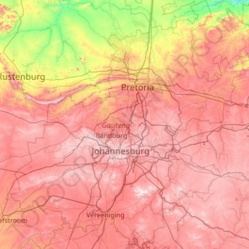
Name: Gauteng topographic map, elevation, terrain.
Location: Gauteng, South Africa (-26.92383 27.15634 -25.10961 29.09842)
Average elevation: 4,610 ft
Minimum elevation: 2,999 ft
Maximum elevation: 6,250 ft
Other topographic maps
Click on a map to view its topography, its elevation and its terrain.
De Vlugt
South Africa > Western Cape > Garden Route District Municipality > George Local Municipality
Average elevation: 1,499 ft
Durbanville
South Africa > Western Cape > City of Cape Town
Durbanville is situated in the northern suburbs of Cape Town, approximately 28 kilometres (17.4 mi) north-east of the city, bordered by Bellville to the south, Brackenfell to the south-east and Kraaifontein to the east. It lies at an altitude of between 100 m (328 ft) to 240 m (787 ft), in the vast rolling…
Average elevation: 515 ft
Alice
South Africa > Eastern Cape > Amathole District Municipality > Nkonkobe Local Municipality > Alice
Average elevation: 1,923 ft
Arniston
South Africa > Western Cape > Overberg District Municipality > Cape Agulhas Local Municipality
Average elevation: 43 ft
Fernie
South Africa > Mpumalanga > Gert Sibande > Albert Luthuli Local Municipality
Average elevation: 4,754 ft
Jansenville
South Africa > Eastern Cape > Sarah Baartman District Municipality > Ikwezi Local Municipality
Average elevation: 1,470 ft
Graaff-Reinet
South Africa > Sarah Baartman District Municipality > Camdeboo Local Municipality
Average elevation: 2,864 ft
Dzanani
South Africa > Limpopo > Vhembe District Municipality > Makhado Local Municipality
Average elevation: 2,733 ft
Aston Bay
South Africa > Eastern Cape > Sarah Baartman District Municipality > Kouga Local Municipality > Aston Bay
Average elevation: 39 ft
Hermanus
South Africa > Western Cape > Overberg District Municipality > Overstrand Local Municipality
Average elevation: 285 ft
Hillcrest
South Africa > KwaZulu-Natal > eThekwini Metropolitan Municipality
Hillcrest is situated in the Upper Highway Area of Durban, approximately 32 kilometres (20 mi) north-west of the city and is bordered by Gillitts and Everton to the east, Waterfall to the north-east and Botha's Hill and Assagay to the north-west. It lies at an altitude of approximately 680 m (2231 ft) above…
Average elevation: 2,051 ft
Msikaba River
South Africa > Eastern Cape > O.R. Tambo District Municipality
Average elevation: 1,516 ft
Tierkloof
South Africa > Western Cape > West Coast District Municipality > Saldanha Bay Local Municipality
Average elevation: 302 ft
Melk River
South Africa > Eastern Cape > Sarah Baartman District Municipality > Blue Crane Route Local Municipality
Average elevation: 2,293 ft
Sutherland
South Africa > Northern Cape > Namakwa District Municipality > Karoo Hoogland Local Municipality
Average elevation: 5,030 ft
Flagstaff
South Africa > Eastern Cape > O.R. Tambo District Municipality > Ingquza Hill Local Municipality
Average elevation: 2,746 ft
Germiston
South Africa > Gauteng > City of Ekurhuleni Metropolitan Municipality
Average elevation: 5,364 ft
Coffee Bay
South Africa > Eastern Cape > O.R. Tambo District Municipality > King Sabata Dalindyebo Local Municipality
Average elevation: 131 ft
Cannon Rocks
South Africa > Eastern Cape > Sarah Baartman District Municipality > Ndlambe Local Municipality
Average elevation: 115 ft
Antjie Boom se Baken
South Africa > Northern Cape > Namakwa District Municipality > Hantam Local Municipality
Average elevation: 3,442 ft
Lusikisiki
South Africa > Eastern Cape > O.R. Tambo District Municipality > Ingquza Hill Local Municipality
Average elevation: 1,847 ft
Komani
South Africa > Eastern Cape > Chris Hani District Municipality > Lukhanji Local Municipality
Average elevation: 3,763 ft
Bethelsdorp
South Africa > Eastern Cape > Nelson Mandela Bay Metropolitan Municipality
Average elevation: 279 ft
Matjiesfontein
South Africa > Western Cape > Central Karoo District Municipality > Laingsburg Local Municipality
Average elevation: 3,189 ft
Cape St. Francis
South Africa > Eastern Cape > Sarah Baartman District Municipality > Kouga Local Municipality
Average elevation: 33 ft
Cofimvaba
South Africa > Eastern Cape > Chris Hani District Municipality > Intsika Yethu Local Municipality
Average elevation: 3,271 ft
Botha
South Africa > Western Cape > Cape Winelands District Municipality > Witzenberg Local Municipality > Botha
Average elevation: 1,056 ft
Lime Acres
South Africa > Northern Cape > ZF Mgcawu District Municipality > Kgatelopele Local Municipality
Average elevation: 4,908 ft
Underberg
South Africa > KwaZulu-Natal > Sisonke District Municipality > Kwa Sani Local Municipality > Underberg
Average elevation: 5,092 ft
Himalya Street Park
South Africa > Gauteng > City of Tshwane Metropolitan Municipality > Pretoria
Average elevation: 4,777 ft
Wet Lands
South Africa > Western Cape > Cape Winelands District Municipality > Stellenbosch Local Municipality > Stellenbosch
Average elevation: 525 ft
Rainfall Dam
South Africa > Free State > Thabo Mofutsanyana District Municipality > Maluti-a-Phofung Local Municipality
Average elevation: 5,600 ft
City of Johannesburg Metropolitan Municipality
South Africa > Gauteng > City of Johannesburg Metropolitan Municipality
Average elevation: 5,299 ft
Riebeek-Wes
South Africa > Western Cape > West Coast District Municipality > Swartland Local Municipality > Riebeek-Wes
Average elevation: 860 ft
Swinburne
South Africa > Free State > Thabo Mofutsanyana District Municipality > Maluti-a-Phofung Local Municipality
Average elevation: 5,505 ft
Fraserburg
South Africa > Northern Cape > Namakwa District Municipality > Karoo Hoogland Local Municipality
Fraserburg is situated at an altitude of 1,385 metres (4,544 ft) above sea level on a high Karoo plateau, north of the Nuweveld Mountains.
Average elevation: 4,160 ft
Richards Bay
South Africa > KwaZulu-Natal > King Cetswayo District Municipality > Richards Bay
Average elevation: 102 ft
Kariega
South Africa > Eastern Cape > Nelson Mandela Bay Metropolitan Municipality
Average elevation: 292 ft
Roodepoort
South Africa > Gauteng > City of Johannesburg Metropolitan Municipality > Roodepoort
Average elevation: 5,289 ft
Franschhoek
South Africa > Western Cape > Cape Winelands District Municipality > Stellenbosch Local Municipality
Average elevation: 1,647 ft