
Make a donation
Gear up for your next adventure:
As an Amazon Associate, this site earns from qualifying purchases at no extra cost to you.
Glen Allen topographic map
Click on the map to display elevation.
Make a donation
Gear up for your next adventure:
As an Amazon Associate, this site earns from qualifying purchases at no extra cost to you.
About this map
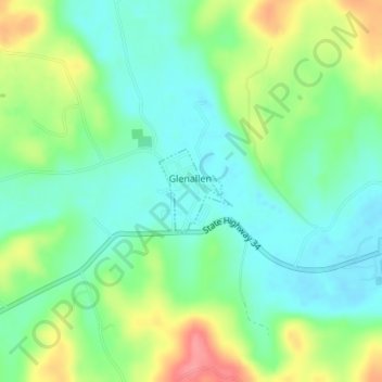
Name: Glen Allen topographic map, elevation, terrain.
Location: Glen Allen, Bollinger County, Missouri, United States (37.31400 -90.03065 37.31991 -90.02407)
Average elevation: 525 ft
Minimum elevation: 433 ft
Maximum elevation: 696 ft
Bollinger County trails, hiking, mountain biking, running and outdoor activities
Make a donation
Gear up for your next adventure:
As an Amazon Associate, this site earns from qualifying purchases at no extra cost to you.
Other topographic maps
Click on a map to view its topography, its elevation and its terrain.
Make a donation
Gear up for your next adventure:
As an Amazon Associate, this site earns from qualifying purchases at no extra cost to you.
Glenallen
United States > Missouri > Bollinger County > Glen Allen > Glenallen
Average elevation: 545 ft