Westervelt topographic map
Interactive map
Click on the map to display elevation.
About this map
![Westervelt topographic map, elevation, terrain](/pub/maps/node/vb51/fwk82nh/thumbnail.jpg)
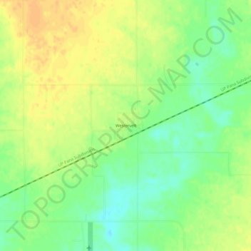
Name: Westervelt topographic map, elevation, terrain.
Location: Westervelt, Shelby County, Illinois, United States (39.45893 -88.88174 39.49893 -88.84174)
Average elevation: 656 ft
Minimum elevation: 597 ft
Maximum elevation: 702 ft
Other topographic maps
Click on a map to view its topography, its elevation and its terrain.
![Findlay topographic map, elevation, terrain](/pub/maps/relation/46m2/bb55k/icon.jpg)
Findlay
United States > Illinois > Shelby County
Findlay, Shelby County, Illinois, 62534, United States
Average elevation: 673 ft
![Todds Point topographic map, elevation, terrain](/pub/maps/node/d9gp/6bmkb9m/icon.jpg)
Todds Point
United States > Illinois > Shelby County
Todds Point, Shelby County, Illinois, United States
Average elevation: 656 ft
![Strasburg topographic map, elevation, terrain](/pub/maps/relation/kqb3/ffd9m/icon.jpg)
Strasburg
United States > Illinois > Shelby County
Strasburg, Shelby County, Illinois, 62465, United States
Average elevation: 640 ft
![Herrick topographic map, elevation, terrain](/pub/maps/relation/v3tj/ggb57/icon.jpg)
Herrick
United States > Illinois > Shelby County
Herrick, Shelby County, Illinois, 62431, United States
Average elevation: 594 ft
![Shelbyville topographic map, elevation, terrain](/pub/maps/relation/k1kl/6fxf3/icon.jpg)
Shelbyville
United States > Illinois > Shelby County > Shelbyville
Shelbyville, Shelby County, Illinois, 62565, United States
Average elevation: 627 ft
![Shelbyville topographic map, elevation, terrain](/pub/maps/node/cx5k/fw9j21h/icon.jpg)
Shelbyville
United States > Illinois > Shelby County > Shelbyville
Shelbyville, Shelby County, Illinois, 62565, United States
Average elevation: 620 ft
![Cowden topographic map, elevation, terrain](/pub/maps/relation/5v57/kk9kl/icon.jpg)
Cowden
United States > Illinois > Shelby County
Cowden, Shelby County, Illinois, 62422, United States
Average elevation: 591 ft
![Oconee topographic map, elevation, terrain](/pub/maps/relation/659m/pphm2/icon.jpg)
Oconee
United States > Illinois > Shelby County > Oconee
Oconee, Shelby County, Illinois, United States
Average elevation: 676 ft