
Make a donation
Gear up for your next adventure:
As an Amazon Associate, this site earns from qualifying purchases at no extra cost to you.
Stephanskirchen topographic map
Click on the map to display elevation.
Make a donation
Gear up for your next adventure:
As an Amazon Associate, this site earns from qualifying purchases at no extra cost to you.
Stephanskirchen
Von November 1944 bis April 1945 befand sich im Gemeindeteil Haidholzen das Außenlager Stephanskirchen des Konzentrationslagers Dachau, in dem etwa 250 KZ-Häftlinge Zwangsarbeit verrichten mussten. Die russischen, polnischen und französischen Kriegsgefangenen wurden in einer Barackensiedlung auf dem Gelände der dortigen Flak-Kaserne untergebracht. Das Hauptgebäude dieser Flak-Kaserne existiert heute noch, seit 1947 befinden sich darin die Produktionsanlagen einer Süßwarenfabrik. Die Häftlinge arbeiteten für regionale Auftraggeber und für die Chiemgauer Vertriebsgesellschaft O.H.G, ein Zweigwerk der Firma BMW, das in Stephanskirchen Flugzeugmotoren fertigte, seinen Betrieb aber nie voll aufnahm. Aus mehreren unabhängigen Quellen geht hervor, dass es im Außenlager Stephanskirchen auch zu Morden an Inhaftierten kam. Gegen Ende 1944 war das Werk Ziel von Luftangriffen, bei denen zwei Belegschaftsmitglieder starben. 30 % der Gebäudesubstanz und 20 % des Maschinenparks wurde zerstört, es entstand ein Schaden in Höhe von 250.000 RM. Auf Befehl Heinrich Himmlers wurde im März und April 1945 eine Evakuierung in rückwärtige Konzentrationslager durchgeführt, in deren Verlauf viele Häftlinge aus Erschöpfung starben oder von der SS erschossen wurden.
Make a donation
Gear up for your next adventure:
As an Amazon Associate, this site earns from qualifying purchases at no extra cost to you.
About this map
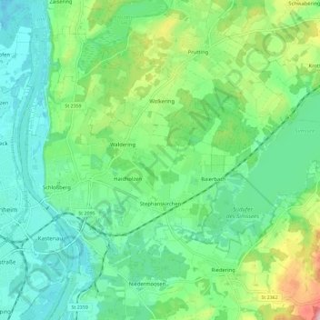
Name: Stephanskirchen topographic map, elevation, terrain.
Average elevation: 1,588 ft
Minimum elevation: 1,414 ft
Maximum elevation: 2,041 ft
Make a donation
Gear up for your next adventure:
As an Amazon Associate, this site earns from qualifying purchases at no extra cost to you.
Other topographic maps
Click on a map to view its topography, its elevation and its terrain.
Make a donation
Gear up for your next adventure:
As an Amazon Associate, this site earns from qualifying purchases at no extra cost to you.
Falkenstein
Deutschland > Bayern > Landkreis Rosenheim > Flintsbach am Inn
Average elevation: 2,014 ft
Kampenwand-Hauptgipfel
Deutschland > Bayern > Landkreis Rosenheim > Aschau im Chiemgau
Average elevation: 4,173 ft
Make a donation
Gear up for your next adventure:
As an Amazon Associate, this site earns from qualifying purchases at no extra cost to you.
Make a donation
Gear up for your next adventure:
As an Amazon Associate, this site earns from qualifying purchases at no extra cost to you.
Großhöhenrain
Deutschland > Bayern > Landkreis Rosenheim > Feldkirchen-Westerham
Average elevation: 1,864 ft
Make a donation
Gear up for your next adventure:
As an Amazon Associate, this site earns from qualifying purchases at no extra cost to you.
Make a donation
Gear up for your next adventure:
As an Amazon Associate, this site earns from qualifying purchases at no extra cost to you.
Make a donation
Gear up for your next adventure:
As an Amazon Associate, this site earns from qualifying purchases at no extra cost to you.
Hochrunstfilze
Deutschland > Bayern > Landkreis Rosenheim > Raubling > Nicklheim
Average elevation: 1,535 ft
Staffelstein
Deutschland > Bayern > Landkreis Rosenheim > Aschau im Chiemgau
Average elevation: 4,127 ft
Make a donation
Gear up for your next adventure:
As an Amazon Associate, this site earns from qualifying purchases at no extra cost to you.
Make a donation
Gear up for your next adventure:
As an Amazon Associate, this site earns from qualifying purchases at no extra cost to you.
Thalham
Deutschland > Bayern > Landkreis Rosenheim > Bruckmühl > Mittenkirchen
Average elevation: 1,765 ft
Geigelstein
Deutschland > Bayern > Landkreis Rosenheim > Aschau im Chiemgau
1991 wurden große Flächen des Geigelstein als Naturschutzgebiet Geigelstein ausgewiesen. Das NSG Geigelstein hat eine Größe von 3135 Hektar und liegt zum Teil im Landkreis Rosenheim mit der Gemeinde Aschau sowie im Landkreis Traunstein mit der Gemeinde Schleching. Mit einem der größten Schutzgebiete auf…
Average elevation: 4,734 ft
Bad Feilnbach
Deutschland > Bayern > Landkreis Rosenheim > Bad Feilnbach > Bad Feilnbach
Average elevation: 2,162 ft
Make a donation
Gear up for your next adventure:
As an Amazon Associate, this site earns from qualifying purchases at no extra cost to you.
Hohenaschau
Deutschland > Bayern > Landkreis Rosenheim
Aschach | Aschau im Chiemgau | Attich | Aufham | Außerkoy | Außerwald | Bach | Berg | Brückl | Bucha | Einfang | Engerndorf | Fellerer | Göttersberg | Grattenbach | Grenzhub | Grünwald | Hainbach | Haindorf | Hammerbach | Hintergschwendt | Hohenaschau im Chiemgau | Höhenberg | Hub | Huben | Innerkoy |…
Average elevation: 2,831 ft
Make a donation
Gear up for your next adventure:
As an Amazon Associate, this site earns from qualifying purchases at no extra cost to you.
Hochries
Deutschland > Bayern > Landkreis Rosenheim > Samerberg
Der Gipfel ist per Bahn von Grainbach aus zu erreichen. Vom Ort geht ein Sessellift zur Mittelstation auf 920 m Höhe. Von dort führt eine Kabinenbahn auf den Gipfel. Die Hochries ist als Rosenheimer „Hausberg“ beliebt bei Wanderern sowie insbesondere Gleitschirm- und Drachenfliegern.
Average elevation: 4,012 ft
Make a donation
Gear up for your next adventure:
As an Amazon Associate, this site earns from qualifying purchases at no extra cost to you.
Elend
Deutschland > Bayern > Landkreis Rosenheim > Wasserburg am Inn > Attel
Average elevation: 1,476 ft
Vagen
Deutschland > Bayern > Landkreis Rosenheim > Feldkirchen-Westerham
Vagen ist ein Ortsteil der Gemeinde Feldkirchen-Westerham im Landkreis Rosenheim. Das Pfarrdorf liegt auf einer Höhe von 525,7 m ü. NN. Vor der Gemeindegebietsreform 1972 war Vagen eine eigenständige Gemeinde.
Average elevation: 1,850 ft
Make a donation
Gear up for your next adventure:
As an Amazon Associate, this site earns from qualifying purchases at no extra cost to you.
Kleiner Traithen
Deutschland > Bayern > Landkreis Rosenheim > Kiefersfelden
Average elevation: 4,383 ft
Make a donation
Gear up for your next adventure:
As an Amazon Associate, this site earns from qualifying purchases at no extra cost to you.
Aich
Deutschland > Bayern > Landkreis Rosenheim > Raubling > Großholzhausen
Average elevation: 1,542 ft
Westerham
Deutschland > Bayern > Landkreis Rosenheim > Feldkirchen-Westerham
Average elevation: 1,909 ft
Make a donation
Gear up for your next adventure:
As an Amazon Associate, this site earns from qualifying purchases at no extra cost to you.
Hammerbach
Deutschland > Bayern > Landkreis Rosenheim > Aschau im Chiemgau
Average elevation: 2,858 ft
Make a donation
Gear up for your next adventure:
As an Amazon Associate, this site earns from qualifying purchases at no extra cost to you.
Unterlaus
Deutschland > Bayern > Landkreis Rosenheim > Feldkirchen-Westerham
Average elevation: 1,926 ft
Make a donation
Gear up for your next adventure:
As an Amazon Associate, this site earns from qualifying purchases at no extra cost to you.
Make a donation
Gear up for your next adventure:
As an Amazon Associate, this site earns from qualifying purchases at no extra cost to you.
Urschalling
Deutschland > Bayern > Landkreis Rosenheim > Prien am Chiemsee > Bach
Average elevation: 1,847 ft
Fachendorf
Deutschland > Bayern > Landkreis Rosenheim > Bad Aibling > Berbling
Average elevation: 1,729 ft
Make a donation
Gear up for your next adventure:
As an Amazon Associate, this site earns from qualifying purchases at no extra cost to you.
Kleinhöhenrain
Deutschland > Bayern > Landkreis Rosenheim > Feldkirchen-Westerham > Großhöhenrain
Average elevation: 1,841 ft
Make a donation
Gear up for your next adventure:
As an Amazon Associate, this site earns from qualifying purchases at no extra cost to you.
Stetten
Deutschland > Bayern > Landkreis Rosenheim > Prien am Chiemsee > Atzing
Average elevation: 1,913 ft
Feldolling
Deutschland > Bayern > Landkreis Rosenheim > Feldkirchen-Westerham
Average elevation: 1,837 ft
Make a donation
Gear up for your next adventure:
As an Amazon Associate, this site earns from qualifying purchases at no extra cost to you.
Make a donation
Gear up for your next adventure:
As an Amazon Associate, this site earns from qualifying purchases at no extra cost to you.
Happinger See
Deutschland > Bayern > Landkreis Rosenheim > Rosenheim > Pfraundorf
Average elevation: 1,480 ft
Siegharting
Deutschland > Bayern > Landkreis Rosenheim > Prien am Chiemsee
Average elevation: 1,972 ft
Make a donation
Gear up for your next adventure:
As an Amazon Associate, this site earns from qualifying purchases at no extra cost to you.
Make a donation
Gear up for your next adventure:
As an Amazon Associate, this site earns from qualifying purchases at no extra cost to you.
Kleinholzhausen
Deutschland > Bayern > Landkreis Rosenheim > Raubling > Großholzhausen
Average elevation: 1,660 ft
Walpersdorf
Deutschland > Bayern > Landkreis Rosenheim > Feldkirchen-Westerham > Unterlaus
Average elevation: 1,850 ft
Heufeld
Deutschland > Bayern > Landkreis Rosenheim > Bruckmühl
Heufeld ist ein Gemeindeteil des Marktes Bruckmühl im Landkreis Rosenheim in Oberbayern. Der Gemeindeteil ist mit den Jahren komplett mit dem Gemeindeteil Bruckmühl zusammengewachsen und liegt auf einer Höhe von 492 m ü. NN.
Average elevation: 1,617 ft
Make a donation
Gear up for your next adventure:
As an Amazon Associate, this site earns from qualifying purchases at no extra cost to you.
Make a donation
Gear up for your next adventure:
As an Amazon Associate, this site earns from qualifying purchases at no extra cost to you.