
Dodge County topographic map
Interactive map
Click on the map to display elevation.
About this map
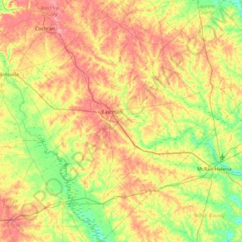
Name: Dodge County topographic map, elevation, terrain.
Location: Dodge County, Georgia, United States (31.90071 -83.37412 32.45243 -82.85804)
Average elevation: 276 ft
Minimum elevation: 131 ft
Maximum elevation: 463 ft
The Heart of Georgia Regional Airport is located three miles east of Eastman off of State Route 46. Elevation 304'. Runway 02/20 is 6,506'x100'and has a precision instrument landing system. The airport is owned by the Heart of Georgia Regional Airport Authority and is home to the Middle Georgia State College Georgia Aviation campus. Middle Georgia State College operates the Federal Aviation Administration's #1 ranked student control tower in the United States. Other businesses at the airport include aircraft manufacturing, aircraft metal finishing, and general metal fabrication. The airport's fixed-base operator is located in the terminal building midfield. The terminal building is named after W. S. Stuckey Sr., founder of Stuckey's Candy Company (now Standard Candy) an aviation pioneer who is from Eastman.
Other topographic maps
Click on a map to view its topography, its elevation and its terrain.
Atlanta
United States > Georgia > Fulton County
Atlanta, Fulton County, Georgia, United States
Average elevation: 932 ft
Savannah
United States > Georgia > Chatham County
Savannah, Chatham County, Georgia, United States
Average elevation: 13 ft
Augusta
United States > Georgia > Augusta
Augusta, Richmond County, Georgia, 30901, United States
Average elevation: 295 ft
Athens
United States > Georgia > Athens
Athens, Athens-Clarke County, Georgia, 303341458, United States
Average elevation: 725 ft
Ellijay
United States > Georgia > Gilmer County
Ellijay, Gilmer County, Georgia, 30540, United States
Average elevation: 1,391 ft
Dahlonega
United States > Georgia > Lumpkin County
Dahlonega, Lumpkin County, Georgia, United States
Average elevation: 1,348 ft
Columbus
United States > Georgia > Muscogee County
Columbus, Muscogee County, Georgia, United States
Average elevation: 427 ft
Gainesville
United States > Georgia > Hall County
Gainesville, Hall County, Georgia, 30501, United States
Average elevation: 1,135 ft
Kennesaw
United States > Georgia > Cobb County
Kennesaw, Cobb County, Georgia, 30144, United States
Average elevation: 1,040 ft
Tybee Island
United States > Georgia > Chatham County
Tybee Island, Chatham County, Georgia, 31328, United States
Average elevation: 3 ft
Canton
United States > Georgia > Cherokee County
Canton, Cherokee County, Georgia, United States
Average elevation: 1,050 ft
Saint Simons Island
United States > Georgia > Glynn County
Saint Simons Island, Glynn County, Georgia, 31561, United States
Average elevation: 7 ft
Atlanta
United States > Georgia > Fulton County
Atlanta, Fulton County, Georgia, 30303, United States
Average elevation: 935 ft
Macon
United States > Georgia > Bibb County
Macon, Bibb County, Georgia, United States
Average elevation: 417 ft
Gwinnett County
Gwinnett County, Georgia, United States
Average elevation: 991 ft
Blairsville
United States > Georgia > Union County
Blairsville, Union County, Georgia, United States
Average elevation: 1,926 ft
Little Ohoopee River
United States > Georgia > Emanuel County
Little Ohoopee River, Emanuel County, Georgia, United States
Average elevation: 256 ft
Doerun
United States > Georgia > Colquitt County
Doerun, Colquitt County, Georgia, 31744, United States
Average elevation: 374 ft
Paulding County
Paulding County, Georgia, United States
Average elevation: 1,020 ft
Alpharetta
United States > Georgia > Fulton County
Alpharetta, Fulton County, Georgia, United States
Average elevation: 1,063 ft
Woodstock
United States > Georgia > Cherokee County
Woodstock, Cherokee County, Georgia, United States
Average elevation: 971 ft
Cloudland Canyon State Park
United States > Georgia > Dade County
Cloudland Canyon State Park, Cherokee Trail, Dade County, Georgia, 30738, United States
Average elevation: 1,601 ft
Reed Bingham State Park
United States > Georgia > Cook County > Adel
Reed Bingham State Park, 542, Adel, Cook County, Georgia, 31620, United States
Average elevation: 213 ft
Sprewell Bluff
United States > Georgia > Talbot County
Sprewell Bluff, Talbot County, Georgia, United States
Average elevation: 676 ft
Carroll County
Carroll County, Georgia, United States
Average elevation: 1,066 ft
Hiawassee
United States > Georgia > Towns County
Hiawassee, Towns County, Georgia, United States
Average elevation: 2,034 ft
Forsyth County
Forsyth County, Georgia, United States
Average elevation: 1,129 ft
Blue Ridge
United States > Georgia > Fannin County
Blue Ridge, Fannin County, Georgia, United States
Average elevation: 1,755 ft
Brunswick
United States > Georgia > Glynn County
Brunswick, Glynn County, Georgia, United States
Average elevation: 7 ft
Arrow Head
United States > Georgia > Columbia County
Arrow Head, Columbia County, Georgia, 30907, United States
Average elevation: 390 ft
Cochran
United States > Georgia > Bleckley County
Cochran, Bleckley County, Georgia, 31014, United States
Average elevation: 358 ft
Fannin County
Fannin County, Georgia, United States
Average elevation: 2,060 ft
Vinings
United States > Georgia > Cobb County
Vinings, Cobb County, Georgia, 30339, United States
Average elevation: 922 ft
Fort Yargo State Park
United States > Georgia > Barrow County > Winder
Fort Yargo State Park, Winder, Barrow County, Georgia, United States
Average elevation: 886 ft
Radio Springs
United States > Georgia > Floyd County
Radio Springs, Floyd County, Georgia, United States
Average elevation: 797 ft
Cup
United States > Georgia > Berrien County
Cup, Berrien County, Georgia, United States
Average elevation: 299 ft
Whigham
United States > Georgia > Grady County
Whigham, Grady County, Georgia, United States
Average elevation: 279 ft
Concord
United States > Georgia > Pike County
Concord, Pike County, Georgia, United States
Average elevation: 817 ft
Helen
United States > Georgia > White County
Helen, White County, Georgia, 30545, United States
Average elevation: 1,601 ft
Robins Air Force Base
United States > Georgia > Houston County
Robins Air Force Base, Houston County, Georgia, 31098, United States
Average elevation: 302 ft
Wilscot
United States > Georgia > Fannin County
Wilscot, Fannin County, Georgia, United States
Average elevation: 2,014 ft
Skidaway Island
United States > Georgia > Chatham County
Skidaway Island, Chatham County, Georgia, 31411, United States
Average elevation: 10 ft
Warner Robins
United States > Georgia > Houston County
Warner Robins, Houston County, Georgia, United States
Average elevation: 331 ft
Lake Oconee
United States > Georgia > Greene County > Lake Oconee
Lake Oconee, Greene County, Georgia, United States
Average elevation: 541 ft