
Make a donation
Gear up for your next adventure:
As an Amazon Associate, this site earns from qualifying purchases at no extra cost to you.
Ulaanbaatar topographic map
Click on the map to display elevation.
Make a donation
Gear up for your next adventure:
As an Amazon Associate, this site earns from qualifying purchases at no extra cost to you.
Ulaanbaatar
Ulaanbaatar (/ʊˌlɑːn ˈbɑːtər/ ; Mongolian: Улаанбаатар, pronounced [ʊˌɮaːɴ‿ˈpaːʰtə̆r] , lit. 'Red Hero'), previously anglicized as Ulan Bator, is the capital and most populous city of Mongolia. It has a population of 1.6 million, and it is the coldest capital city in the world by average yearly temperature. The municipality is located in north central Mongolia at an elevation of about 1,300 metres (4,300 ft) in a valley on the Tuul River. The city was founded in 1639 as a nomadic Buddhist monastic centre, changing location 28 times, and was permanently settled at its modern location in 1778.
Make a donation
Gear up for your next adventure:
As an Amazon Associate, this site earns from qualifying purchases at no extra cost to you.
About this map
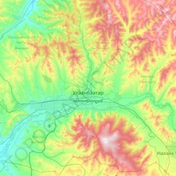
Name: Ulaanbaatar topographic map, elevation, terrain.
Location: Ulaanbaatar, Mongolia (47.73286 106.53455 48.14897 107.22004)
Average elevation: 5,098 ft
Minimum elevation: 3,953 ft
Maximum elevation: 7,415 ft
Make a donation
Gear up for your next adventure:
As an Amazon Associate, this site earns from qualifying purchases at no extra cost to you.
Other topographic maps
Click on a map to view its topography, its elevation and its terrain.
Make a donation
Gear up for your next adventure:
As an Amazon Associate, this site earns from qualifying purchases at no extra cost to you.
Make a donation
Gear up for your next adventure:
As an Amazon Associate, this site earns from qualifying purchases at no extra cost to you.
Make a donation
Gear up for your next adventure:
As an Amazon Associate, this site earns from qualifying purchases at no extra cost to you.