
Make a donation
Gear up for your next adventure:
As an Amazon Associate, this site earns from qualifying purchases at no extra cost to you.
Serengeti topographic map
Click on the map to display elevation.
Make a donation
Gear up for your next adventure:
As an Amazon Associate, this site earns from qualifying purchases at no extra cost to you.
About this map
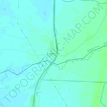
Name: Serengeti topographic map, elevation, terrain.
Location: Serengeti, Bunda Town, Lake Zone, Tanzania (-2.21195 33.84924 -2.17195 33.88924)
Average elevation: 3,740 ft
Minimum elevation: 3,730 ft
Maximum elevation: 3,757 ft
Make a donation
Gear up for your next adventure:
As an Amazon Associate, this site earns from qualifying purchases at no extra cost to you.
Other topographic maps
Click on a map to view its topography, its elevation and its terrain.
Kilimanjaro
Mount Kilimanjaro (/ˌkɪlɪmənˈdʒɑːroʊ/) is a dormant volcano in Tanzania. It is the highest mountain in Africa and the highest free-standing mountain above sea level in the world: 5,895 m (19,341 ft) above sea level and 4,900 m (16,100 ft) above its plateau base. It is also the highest volcano in the…
Average elevation: 5,043 ft
Shinyanga Region
Four distinct agro-ecological zones are established within the Shinyanga Region mostly based on topographical factors and local meteorological conditions. Parts of Kishapu District and a few wards in Shinyanga District Council are included in the eastern zone. Sandalized soils and thick clay soils are features…
Average elevation: 3,944 ft
Make a donation
Gear up for your next adventure:
As an Amazon Associate, this site earns from qualifying purchases at no extra cost to you.
Make a donation
Gear up for your next adventure:
As an Amazon Associate, this site earns from qualifying purchases at no extra cost to you.
Make a donation
Gear up for your next adventure:
As an Amazon Associate, this site earns from qualifying purchases at no extra cost to you.
Make a donation
Gear up for your next adventure:
As an Amazon Associate, this site earns from qualifying purchases at no extra cost to you.
Make a donation
Gear up for your next adventure:
As an Amazon Associate, this site earns from qualifying purchases at no extra cost to you.
Shinyanga Region
Four distinct agro-ecological zones are established within the Shinyanga Region mostly based on topographical factors and local meteorological conditions. Parts of Kishapu District and a few wards in Shinyanga District Council are included in the eastern zone. Sandalized soils and thick clay soils are features…
Average elevation: 3,944 ft
Make a donation
Gear up for your next adventure:
As an Amazon Associate, this site earns from qualifying purchases at no extra cost to you.
Kilimanjaro
Kilimanjaro is the fourth most topographically prominent peak on Earth. It is part of Kilimanjaro National Park and is a major hiking and climbing destination. Because of its shrinking glaciers and ice fields, which are projected to disappear between 2025 and 2035, it has been the subject of many scientific…
Average elevation: 5,043 ft
Make a donation
Gear up for your next adventure:
As an Amazon Associate, this site earns from qualifying purchases at no extra cost to you.
Katavi Region
At an altitude of 1,000 to 2,500 meters above sea level, the Katavi Region has typical yearly temperatures between 26 and 30 degrees Celsius. The range of the average annual rainfall is 920 to 1,200 mm. The district is made up of gentle plains, plateaus, tiny mountain peaks, moderate hills, and Mwese…
Average elevation: 3,701 ft
Make a donation
Gear up for your next adventure:
As an Amazon Associate, this site earns from qualifying purchases at no extra cost to you.
Kigoma Region
Kigoma Region is on a plateau that slopes from the northeast at about 1,750 metres (5,740 ft) down to 800 metres (2,600 ft) at the shore of lake Tanganyika. The topography in the north and east is gently rolling hills that gradually become steeper as they get closer to the Albertine Rift margin. The most…
Average elevation: 3,986 ft
Make a donation
Gear up for your next adventure:
As an Amazon Associate, this site earns from qualifying purchases at no extra cost to you.
Kilimanjaro
Mount Kilimanjaro (/ˌkɪlɪmənˈdʒɑːroʊ/) is a dormant volcano in Tanzania. It is the highest mountain in Africa and the highest free-standing mountain above sea level in the world, at 5,895 m (19,341 ft) above sea level and 4,900 m (16,100 ft) above its plateau base. It is also the highest volcano in…
Average elevation: 5,043 ft
Make a donation
Gear up for your next adventure:
As an Amazon Associate, this site earns from qualifying purchases at no extra cost to you.
Tanga Region
Tanga Region is the 15th largest region by size with an area of 26,667 km2 (10,296 sq mi), after Songwe Region at 27,656 km2 (10,678 sq mi). An area occupying 3% of the country. In comparison, Tanga is larger than the African nation of Burundi at 25,680 square kilometers. The Tanga Region shares land borders…
Average elevation: 1,890 ft
Make a donation
Gear up for your next adventure:
As an Amazon Associate, this site earns from qualifying purchases at no extra cost to you.
Iringa Region
The elevation of Iringa varies from 900 to 2,300 meters above sea level. A significant scarp that can reach 800 meters in height and is the eastern portion of the Great Rift Valley surrounds the area on all sides. Iringa is hence situated in Tanzania's southern highlands, bordering Mbeya, Njombe, Morogoro,…
Average elevation: 3,629 ft
Make a donation
Gear up for your next adventure:
As an Amazon Associate, this site earns from qualifying purchases at no extra cost to you.
Kigoma Region
Kigoma Region is on a plateau that slopes from the northeast at about 1,750 metres (5,740 ft) down to 800 metres (2,600 ft) at the shore of lake Tanganyika. The topography in the north and east is gently rolling hills that gradually become steeper as they get closer to the Albertine Rift margin. The most…
Average elevation: 3,986 ft
Make a donation
Gear up for your next adventure:
As an Amazon Associate, this site earns from qualifying purchases at no extra cost to you.
Mara River
The altitudes in the basin range from 2,932 m around the sources in the Mau Escarpment to 1,134 m around Lake Victoria. The amount of precipitation varies according to these altitudes. The Mau Escarpment receives most rainfall with a mean annual rainfall between 1,000 and 1,750 mm. The transboundary middle…
Average elevation: 5,102 ft
Kilimanjaro
Kilimanjaro is the fourth most topographically prominent peak on Earth. It is part of Kilimanjaro National Park and is a major hiking and climbing destination. Because of its shrinking glaciers and ice fields, which are projected to disappear between 2025 and 2035, it has been the subject of many scientific…
Average elevation: 5,043 ft
Make a donation
Gear up for your next adventure:
As an Amazon Associate, this site earns from qualifying purchases at no extra cost to you.
Monduli
A number of isolated mountains (Monduli, Lepurko, Loosimingori, and Lengai) and broad rolling plains characterize the land landscape. The heights range from 600m in the low elevations to 2900m in the high elevations. The District's vegetation includes a combination of forest, bushland, woodland grassland, and…
Average elevation: 4,491 ft
Kilimanjaro
Mount Kilimanjaro (/ˌkɪlɪmənˈdʒɑːroʊ/) is a dormant volcano in Tanzania. It is the highest mountain in Africa and the highest free-standing mountain above sea level in the world: 5,895 m (19,341 ft) above sea level and 4,900 m (16,100 ft) above its plateau base. It is also the highest volcano in the…
Average elevation: 5,043 ft
Make a donation
Gear up for your next adventure:
As an Amazon Associate, this site earns from qualifying purchases at no extra cost to you.
Pangani
Formerly the main course towards the sea was alternatively called "Ruvu" and "Pangani". Nowadays that has been settled as "Pangani" from the Nyumba ya Mungu reservoir to the Ocean. While the Swahili call it "Pangani" (meaning distribute or arrange), it is called "Luffu" by the Wasambara (indigenous to the…
Average elevation: 2,516 ft
Kilimanjaro
Mount Kilimanjaro (/ˌkɪlɪmənˈdʒɑːroʊ/) is a dormant volcano in Tanzania. It is the highest mountain in Africa and the highest free-standing mountain above sea level in the world, situated at 5,895 m (19,341 ft) above sea level and 4,900 m (16,100 ft) above its plateau base. It is also the highest…
Average elevation: 5,043 ft
Make a donation
Gear up for your next adventure:
As an Amazon Associate, this site earns from qualifying purchases at no extra cost to you.
Make a donation
Gear up for your next adventure:
As an Amazon Associate, this site earns from qualifying purchases at no extra cost to you.
Kilimanjaro
Mount Kilimanjaro (/ˌkɪlɪmənˈdʒɑːroʊ/) is a dormant volcano in Tanzania. It is the highest mountain in Africa and the highest free-standing mountains above sea level in the world, at 5,895 m (19,341 ft) above sea level and 4,900 m (16,100 ft) above its plateau base. It is also the highest volcano in…
Average elevation: 5,043 ft
Make a donation
Gear up for your next adventure:
As an Amazon Associate, this site earns from qualifying purchases at no extra cost to you.
Make a donation
Gear up for your next adventure:
As an Amazon Associate, this site earns from qualifying purchases at no extra cost to you.
Lake Chala
Lake Chala's average annual rainfall is about 565 millimetres (22.2 in). The lake surface has an average annual evaporation of near 1,735 millimetres (68.3 in). Approximately 80 percent of the lake's inflow comes from groundwater, which is derived mostly from rainfall in the montane forest zone of Mount…
Average elevation: 2,953 ft
Make a donation
Gear up for your next adventure:
As an Amazon Associate, this site earns from qualifying purchases at no extra cost to you.
Make a donation
Gear up for your next adventure:
As an Amazon Associate, this site earns from qualifying purchases at no extra cost to you.
Make a donation
Gear up for your next adventure:
As an Amazon Associate, this site earns from qualifying purchases at no extra cost to you.
Make a donation
Gear up for your next adventure:
As an Amazon Associate, this site earns from qualifying purchases at no extra cost to you.
Make a donation
Gear up for your next adventure:
As an Amazon Associate, this site earns from qualifying purchases at no extra cost to you.
Make a donation
Gear up for your next adventure:
As an Amazon Associate, this site earns from qualifying purchases at no extra cost to you.