
Ouémé Department topographic map
Interactive map
Click on the map to display elevation.
About this map
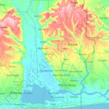
Name: Ouémé Department topographic map, elevation, terrain.
Location: Ouémé Department, Benin (6.35806 2.38614 6.99763 2.72999)
Average elevation: 141 ft
Minimum elevation: -10 ft
Maximum elevation: 535 ft
Ouémé Department borders Zou Department to the north, Plateau Department to the northeast, Nigeria to the southeast, the Atlantic Ocean to the south, Littoral Department to the southwest, and Atlantique Department to the west. It is located in a coastal area that has interconnected lakes and lagoons and elongated coastlines with wide marshes. The southern regions of Benin receive two spells of rain from March to July and September to November, while the northern regions of the country receive one season of rainfall from May to September. The country receives an average annual rainfall of around 1,200 mm (47 in), but Ouémé Department receives less rainfall. The department has mostly low-lying sandy coastal plains towards the Atlantic Ocean, marshes, lagoons and lakes, including part of Lake Nokoué in the southwest. The highest elevation in the department around the coastal plains is 20 m (66 ft) compared to the average 200 m (660 ft) above average mean sea level of the country.
Other topographic maps
Click on a map to view its topography, its elevation and its terrain.
Abomey-Calavi
Benin > Atlantique Department > Abomey-Calavi
Abomey-Calavi, Atlantique Department, Benin
Average elevation: 43 ft
Tanguieta
Benin > Atakora Department > Tanguièta
Tanguieta, Tanguièta, Atakora Department, Benin
Average elevation: 961 ft
Serou
Benin > Borgou Department > Sinendé
Serou, Sinendé, Borgou Department, Benin
Average elevation: 1,181 ft
Tanguièta
Benin > Atakora Department > Tanguièta
Tanguièta, Atakora Department, Benin
Average elevation: 883 ft
Porto-Novo
Benin > Ouémé Department > Porto Novo
Porto-Novo, Porto Novo, Ouémé Department, Benin
Average elevation: 49 ft