
Littoral topographic map
Interactive map
Click on the map to display elevation.
About this map
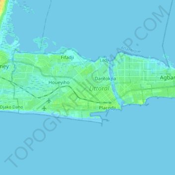
Name: Littoral topographic map, elevation, terrain.
Location: Littoral, Benin (6.33728 2.35457 6.39924 2.49584)
Average elevation: 7 ft
Minimum elevation: -13 ft
Maximum elevation: 66 ft
Other topographic maps
Click on a map to view its topography, its elevation and its terrain.
Abomey-Calavi
Benin > Atlantique Department > Abomey-Calavi
Abomey-Calavi, Atlantique Department, Benin
Average elevation: 43 ft
Tanguieta
Benin > Atakora Department > Tanguièta
Tanguieta, Tanguièta, Atakora Department, Benin
Average elevation: 961 ft
Serou
Benin > Borgou Department > Sinendé
Serou, Sinendé, Borgou Department, Benin
Average elevation: 1,181 ft
Tanguièta
Benin > Atakora Department > Tanguièta
Tanguièta, Atakora Department, Benin
Average elevation: 883 ft
Porto-Novo
Benin > Ouémé Department > Porto Novo
Porto-Novo, Porto Novo, Ouémé Department, Benin
Average elevation: 49 ft