
Make a donation
Gear up for your next adventure:
As an Amazon Associate, this site earns from qualifying purchases at no extra cost to you.
Zaire Province topographic map
Click on the map to display elevation.
Make a donation
Gear up for your next adventure:
As an Amazon Associate, this site earns from qualifying purchases at no extra cost to you.
About this map
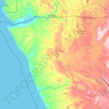
Name: Zaire Province topographic map, elevation, terrain.
Location: Zaire Province, Angola (-7.88566 12.07211 -5.82643 14.95470)
Average elevation: 958 ft
Minimum elevation: -3 ft
Maximum elevation: 3,845 ft
Make a donation
Gear up for your next adventure:
As an Amazon Associate, this site earns from qualifying purchases at no extra cost to you.
Other topographic maps
Click on a map to view its topography, its elevation and its terrain.
Saurimo
Saurimo is located in northeastern Angola at an elevation of 1,084 m (3,556 ft) above sea level. It is a garrison town and local market center.
Average elevation: 3,497 ft
Cuito
The town sits on the eastern flank of the Bie Plateau. The climate is unusually cool for its tropical location. The average annual temperature is 18 °C, largely due to its high altitude. The coolest period is May to August when almost no rain falls. September and October are the hottest months with a little…
Average elevation: 5,482 ft
Make a donation
Gear up for your next adventure:
As an Amazon Associate, this site earns from qualifying purchases at no extra cost to you.
Make a donation
Gear up for your next adventure:
As an Amazon Associate, this site earns from qualifying purchases at no extra cost to you.
Make a donation
Gear up for your next adventure:
As an Amazon Associate, this site earns from qualifying purchases at no extra cost to you.