
Wadi al Hayaa topographic map
Interactive map
Click on the map to display elevation.
About this map
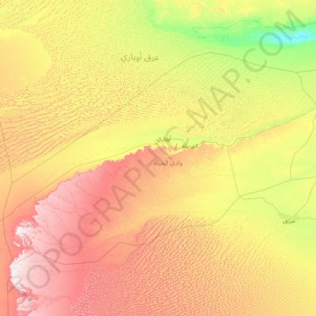
Name: Wadi al Hayaa topographic map, elevation, terrain.
Location: Wadi al Hayaa, Libya (25.54784 11.29049 27.29223 14.18860)
Average elevation: 1,870 ft
Minimum elevation: 935 ft
Maximum elevation: 3,763 ft
The district is bordered by Wadi al Shatii in north, Sabha in east, Murzuq in south and Ghat in the west. The district is part of Fezzen geographical division of Libya which is mostly desert. The region receives an annual rainfall of 2.5 in (64 mm). There are no perennial rivers in the region, but the region is abundant with groundwater aquifers. Libya has mostly a flat undulating plain and occasional plateau, with an average elevation of around 423 m (1,388 ft). Around 91 per cent of the land is covered by desert, with only 8.8 per cent agricultural land (with only 1% arable lands) and 0.1 per cent of forests. The major resource found in the area is manganese. The Fezzen region has a desert climate. Dust storms lasting four to eight days are quite common during Spring. Fezzen is in southwest Libya.
Other topographic maps
Click on a map to view its topography, its elevation and its terrain.
Cyrene
Libya > Jabal al Akhdar > Shahhat
Cyrene, شحات-سوسه Shahha-Susah, Shahhat, Jabal al Akhdar, Libya
Average elevation: 1,831 ft
Ptolemais, Cyrenaica
Libya > Marj > (Al Dirsiyah (Tolmeitha
Ptolemais, Cyrenaica, طلميثه(الدرسيه)-شاطئ لملكا AlDirsiyah(tlmethah) -lamlaka Beach, (Al Dirsiyah (Tolmeitha, Marj, Libya
Average elevation: 125 ft
Mintaqat al Ghanimahغنيمة
Libya > Murqub > Mintaqat al Ghanimahغنيمة
Mintaqat al Ghanimahغنيمة, Murqub, Libya
Average elevation: 194 ft