Geolocate

Benghazi topographic map

Click on the map to display elevation.

Benghazi

The largest Ottoman architectural monument in Benghazi is the late 19th-century Ottoman palace in El-Berka; built during the rule of Rashid Pasha II. The front elevation was completed in 1895, whilst the side sections were added later during Italian rule. The white and green structure houses 360 rooms; and is on a tract of land where Gamal Abdel Nasser Street meets al-Saqzali Street; south of the 28 March football stadium.

Wikipedia (CC-BY-SA 3.0)

About this map

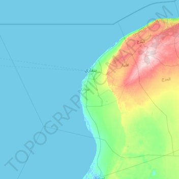
Name: Benghazi topographic map, elevation, terrain.

Location: Benghazi, Libya (31.00704 18.65092 32.73357 21.31909)

Average elevation: 226 ft

Minimum elevation: -13 ft

Maximum elevation: 2,234 ft

Other topographic maps

Click on a map to view its topography, its elevation and its terrain.

Bani Walid

Libya > Bani Walid

Average elevation: 817 ft

Abu Sitta

Libya > Tripoli

Average elevation: 26 ft

Assarraj

Libya > Jafara

Average elevation: 82 ft

Misrata

Libya > Bani Walid

Average elevation: 39 ft

Gogaas

Libya > Murqub

Average elevation: 456 ft

Al Bivio

Libya > Tripoli > Tripoli

Average elevation: 52 ft

Ras Lanuf

Libya > Sirte

Average elevation: 33 ft

Benghazi

Libya > Benghazi

The largest Ottoman architectural monument in Benghazi is the late 19th-century Ottoman palace in El-Berka; built during the rule of Rashid Pasha II. The front elevation was completed in 1895, whilst the side sections were added later during Italian rule. The white and green structure houses 360 rooms; and is…

Average elevation: 79 ft

Al Athrun

Libya > Derna

Average elevation: 374 ft

Kashlav

Libya > Tripoli

Average elevation: 62 ft

Tarhuna

Libya > Murqub

During the late 1950s and into the 1960s, the British Royal Air Force (RAF) established a bombing range on the outskirts of the town. It was manned by RAF personnel from nearby RAF Idris and was used by English Electric Canberra bombers from various bases in Germany. The range consisted of a main control tower…

Average elevation: 1,181 ft

Ar Rayāyinah

Libya > Jabal al Gharbi

Average elevation: 2,093 ft

Hey al-Andalus

Libya > Tripoli

Average elevation: 36 ft

Darnah

Libya > Derna

Average elevation: 285 ft

صبراتة

Libya > Nuqat al Khams

Average elevation: 46 ft

Janzur

Libya > Jafara

On March 6, 1912, the Italian forces became the first to use airships in war, as two dirigibles dropped bombs on Turkish troops and Libyan Mujahideen encamped at Janzour, from an altitude of 6,000 feet.

Average elevation: 66 ft

Mizda

Libya > Jabal al Gharbi

Average elevation: 1,594 ft

Gharyan

Libya > Jabal al Gharbi

Gharyan experiences a hot semi-arid climate (Köppen climate classification BSh), with blazing summers and cool winters; its winters being one of the coldest in Libya. Due to its winter months being 5 °C or 9 °F degrees cooler than Tripoli, the locality sees a cooler variation of said climate, though its…

Average elevation: 1,657 ft

Sawani Bin Adam

Libya > Jafara

Average elevation: 210 ft

Misrata

Libya > Bani Walid

Average elevation: 39 ft

جبل المشاشية

Libya > Wadi al Shatii

Average elevation: 3,038 ft

Az-zintan

Libya > Jabal al Gharbi

Average elevation: 2,297 ft

Al Krimiya

Libya > Jafara

Average elevation: 177 ft

Al Badir

Libya > Murzuq

Average elevation: 1,391 ft

Az-zintan

Libya > Jabal al Gharbi

Average elevation: 2,297 ft

Ghadames

Libya > Nalut

Average elevation: 1,086 ft

Gharyan

Libya > Jabal al Gharbi

Gharyan experiences a hot semi-arid climate (Köppen climate classification BSh), with blazing summers and cool winters; its winters being one of the coldest in Libya. Due to its winter months being 5 °C or 9 °F degrees cooler than Tripoli, the locality sees a cooler variation of said climate, though its…

Average elevation: 1,657 ft

Al saba

Libya > Jabal al Akhdar

Average elevation: 2,336 ft

Qaryat Omar al Mukhtar

Libya > Jabal al Akhdar

Average elevation: 2,431 ft

Bayda

Libya > Jabal al Akhdar

The city of Bayda has a mild Mediterranean climate (Csb, according to the Köppen climate classification) with an average annual precipitation of 540 millimetres or 21 inches. It is famous for recurring snow falls and heavy rains, where the temperature rises in the summer time to 30 °C (86 °F), but in the…

Average elevation: 1,654 ft

Al Zawiyah

Libya > Az Zawiya District

Average elevation: 102 ft

Zuara

Libya > Nuqat al Khams

Average elevation: 13 ft

Yafran

Libya > Jabal al Gharbi

Average elevation: 1,831 ft

Ghadames

Libya > Nalut

Average elevation: 1,086 ft

Wadi Qattara Passage

Libya > Benghazi

Average elevation: 121 ft

Ajdabiya

Libya > Al Wahat

Average elevation: 95 ft

Bardia

Libya > Butnan

Average elevation: 266 ft

Zuara

Libya > Nuqat al Khams

Average elevation: 13 ft

Jebel Akhdar

Libya > Jabal al Akhdar

Average elevation: 2,779 ft

Al Jawf

Libya > Kufra

The city has an elevation of 382.2 m (1,254 feet). In 2022, the city's population was 18,587. Al Jawf receives almost no rain, averaging only 2.5 millimetres or 0.1 inches per year. Summer high temperatures average above 38 °C or 100 °F.

Average elevation: 1,266 ft

Battah

Libya > Marj

Average elevation: 1,125 ft

Assarraj

Libya > Jafara

Average elevation: 82 ft

Asbi'a

Libya > Jabal al Gharbi

Average elevation: 2,142 ft

Al Jawf

Libya > Kufra

The city has an elevation of 382.2 m (1,254 feet). in 2022, the city's population was 18,587. Al Jawf receives almost no rain whatsoever, averaging only 2.5 millimetres or 0.1 inches per year. Summer high temperatures average above 38 °C or 100 °F.

Average elevation: 1,266 ft

Al Aziziya

Libya > Jafara

Average elevation: 387 ft

Sinawin

Libya > Nalut

Average elevation: 1,483 ft

Adribe

Libya > Tripoli > Tripoli

Average elevation: 69 ft

Swani Al-Obaidia

Libya > Benghazi

Average elevation: 95 ft

صبراتة

Libya > Nuqat al Khams

Average elevation: 46 ft

Tobruk

Libya > Butnan

Average elevation: 210 ft

Yafran

Libya > Jabal al Gharbi

Average elevation: 1,831 ft

Bab Akara

Libya > Tripoli

Average elevation: 49 ft

Bani Walid

Libya > Bani Walid

Average elevation: 817 ft

Al Qawasim

Libya > Jabal al Gharbi

Average elevation: 1,696 ft

Tarout

Libya > Wadi al Shatii

Average elevation: 1,148 ft

Surman

Libya

Average elevation: 89 ft

Zliten

Libya > Bani Walid

Average elevation: 115 ft

Qasr Bin Ghashir

Libya > Jafara

Average elevation: 249 ft

Tajura

Libya > Tripoli > Tripoli

Average elevation: 33 ft

Al Mansura

Libya > Wadi al Shatii

Average elevation: 1,250 ft

Qasr Abu Hadi

Libya > Sirte

Average elevation: 210 ft

Zliten

Libya > Bani Walid

Average elevation: 115 ft

Al Aziziya

Libya > Jafara

Average elevation: 387 ft

Bayda

Libya > Jabal al Akhdar

The city of Bayda has a mild Mediterranean climate (Csb, according to the Köppen climate classification) with an average annual precipitation of 540 millimetres or 21 inches. It is famous for recurring snow falls and heavy rains, where the temperature rises in the summer time to 30 °C (86 °F), but in the…

Average elevation: 1,654 ft

Nalut

Libya > Nalut

Average elevation: 1,585 ft

Azzahra

Libya > Jafara

Average elevation: 243 ft

Cyrene

Libya > Jabal al Akhdar > Shahhat

Average elevation: 1,831 ft

Daryanah

Libya > Benghazi

Average elevation: 36 ft

Elba island

Libya > Butnan

Average elevation: 256 ft

Bint Bayyah

Libya > Wadi al Hayaa

Average elevation: 1,581 ft

Bab Al Firnaj

Libya > Tripoli

Average elevation: 49 ft

Old city of Tripoli

Libya > Tripoli

Average elevation: 23 ft

Hun

Libya > District of Al-Jufra

Average elevation: 906 ft

Tajura

Libya > Tripoli > Tripoli

Average elevation: 33 ft

Yafran

Libya > Jabal al Gharbi

Average elevation: 1,831 ft

Sirte

Libya > Sirte

Average elevation: 75 ft

Misrata

Libya > Bani Walid

Average elevation: 39 ft

Ghat

Libya > Ghat

Average elevation: 2,572 ft

Al Kharobah

Libya > Marj

Average elevation: 823 ft

AZWAIYA

Libya > Wadi al Shatii

Average elevation: 1,240 ft

Ghot Alsha'al

Libya > Tripoli

Average elevation: 59 ft

Darnah

Libya > Derna

Average elevation: 285 ft

Ain Zara

Libya > Tripoli

Average elevation: 180 ft

Tarhuna

Libya > Murqub

During the late 1950s and into the 1960s, the RAF established a bombing range on the outskirts of the town. It was manned by RAF personnel from nearby RAF Idris and it was used by Canberra bombers from various bases in Germany. The range consisted of a main control tower with full equipment for communication…

Average elevation: 1,181 ft

Sabha

Libya > Sabha

Average elevation: 1,424 ft

Nalut

Libya > Nalut

Average elevation: 1,585 ft

Murzuq

Libya > Murzuq

Average elevation: 1,509 ft

Marj

Libya > Marj

Average elevation: 1,109 ft

Al Zawiyah

Libya > Az Zawiya District

Average elevation: 102 ft

Qabilat al Hajj `Umran

Libya > Jabal al Gharbi

Average elevation: 2,434 ft

Zliten

Libya > Bani Walid

Average elevation: 115 ft

Bayda

Libya > Jabal al Akhdar

The city of Bayda has a mild Mediterranean climate (Csb, according to the Köppen climate classification) with an average annual precipitation of 540 millimetres or 21 inches. It is famous for recurring snow falls and heavy rains, where the temperature rises in the summer time to 30 °C (86 °F), but in the…

Average elevation: 1,654 ft

Ain Zara

Libya > Tripoli > Tripoli

Average elevation: 180 ft

Sirte

Libya > Sirte

Average elevation: 75 ft

Salah Aldeen

Libya > Tripoli > Tripoli

Average elevation: 108 ft

Bab Bin Ghashir

Libya > Tripoli

Average elevation: 52 ft

Sabha

Libya > Sabha

Average elevation: 1,424 ft

Benina

Libya > Benghazi

Average elevation: 361 ft

Old city of Tripoli

Libya > Tripoli

Average elevation: 23 ft

Gear up for your next adventure:

🔌Solar Panel Charger - Charge gear sustainably outdoors
🪶LED Camping Lantern - Bright lantern for camp lighting
🛡️Insect Repellent - Protection against bugs during outdoor activities
🎁Geography Themed Gifts - Unique gift ideas for map lovers and geography enthusiasts
🪶Paracord Bracelet - Survival bracelet with built‑in tools

As an Amazon Associate, this site earns from qualifying purchases at no extra cost to you.