
Make a donation
Gear up for your next adventure:
As an Amazon Associate, this site earns from qualifying purchases at no extra cost to you.
Al Wahat topographic map
Click on the map to display elevation.
Make a donation
Gear up for your next adventure:
As an Amazon Associate, this site earns from qualifying purchases at no extra cost to you.
About this map
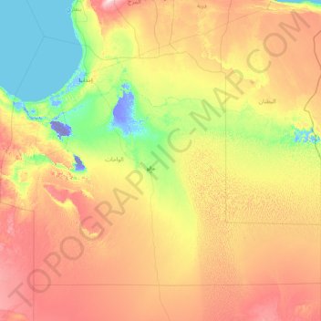
Name: Al Wahat topographic map, elevation, terrain.
Location: Al Wahat, Libya (27.00767 18.49929 31.41107 25.00250)
Average elevation: 413 ft
Minimum elevation: -157 ft
Maximum elevation: 1,699 ft
Make a donation
Gear up for your next adventure:
As an Amazon Associate, this site earns from qualifying purchases at no extra cost to you.
Other topographic maps
Click on a map to view its topography, its elevation and its terrain.
Benghazi
The largest Ottoman architectural monument in Benghazi is the late 19th-century Ottoman palace in El-Berka; built during the rule of Rashid Pasha II. The front elevation was completed in 1895, whilst the side sections were added later during Italian rule. The white and green structure houses 360 rooms; and is…
Average elevation: 79 ft
Make a donation
Gear up for your next adventure:
As an Amazon Associate, this site earns from qualifying purchases at no extra cost to you.
Tarhuna
During the late 1950s and into the 1960s, the British Royal Air Force (RAF) established a bombing range on the outskirts of the town. It was manned by RAF personnel from nearby RAF Idris and was used by English Electric Canberra bombers from various bases in Germany. The range consisted of a main control tower…
Average elevation: 1,181 ft
Make a donation
Gear up for your next adventure:
As an Amazon Associate, this site earns from qualifying purchases at no extra cost to you.
Gharyan
Gharyan experiences a hot semi-arid climate (Köppen climate classification BSh), with blazing summers and cool winters; its winters being one of the coldest in Libya. Due to its winter months being 5 °C or 9 °F degrees cooler than Tripoli, the locality sees a cooler variation of said climate, though its…
Average elevation: 1,657 ft
Make a donation
Gear up for your next adventure:
As an Amazon Associate, this site earns from qualifying purchases at no extra cost to you.
Make a donation
Gear up for your next adventure:
As an Amazon Associate, this site earns from qualifying purchases at no extra cost to you.
Bayda
The city of Bayda has a mild Mediterranean climate (Csb, according to the Köppen climate classification) with an average annual precipitation of 540 millimetres or 21 inches. It is famous for recurring snow falls and heavy rains, where the temperature rises in the summer time to 30 °C (86 °F), but in the…
Average elevation: 1,654 ft
Make a donation
Gear up for your next adventure:
As an Amazon Associate, this site earns from qualifying purchases at no extra cost to you.
Make a donation
Gear up for your next adventure:
As an Amazon Associate, this site earns from qualifying purchases at no extra cost to you.
Make a donation
Gear up for your next adventure:
As an Amazon Associate, this site earns from qualifying purchases at no extra cost to you.
Make a donation
Gear up for your next adventure:
As an Amazon Associate, this site earns from qualifying purchases at no extra cost to you.
Make a donation
Gear up for your next adventure:
As an Amazon Associate, this site earns from qualifying purchases at no extra cost to you.
Bayda
The city of Bayda has a mild Mediterranean climate (Csb, according to the Köppen climate classification) with an average annual precipitation of 540 millimetres or 21 inches. It is famous for recurring snow falls and heavy rains, where the temperature rises in the summer time to 30 °C (86 °F), but in the…
Average elevation: 1,654 ft
Make a donation
Gear up for your next adventure:
As an Amazon Associate, this site earns from qualifying purchases at no extra cost to you.
Make a donation
Gear up for your next adventure:
As an Amazon Associate, this site earns from qualifying purchases at no extra cost to you.
Bayda
The city of Bayda has a mild Mediterranean climate (Csb, according to the Köppen climate classification) with an average annual precipitation of 540 millimetres or 21 inches. It is famous for recurring snow falls and heavy rains, where the temperature rises in the summer time to 30 °C (86 °F), but in the…
Average elevation: 1,654 ft
Tarhuna
During the late 1950s and into the 1960s, the RAF established a bombing range on the outskirts of the town. It was manned by RAF personnel from nearby RAF Idris and it was used by Canberra bombers from various bases in Germany. The range consisted of a main control tower with full equipment for communication…
Average elevation: 1,181 ft
Make a donation
Gear up for your next adventure:
As an Amazon Associate, this site earns from qualifying purchases at no extra cost to you.
Make a donation
Gear up for your next adventure:
As an Amazon Associate, this site earns from qualifying purchases at no extra cost to you.
Make a donation
Gear up for your next adventure:
As an Amazon Associate, this site earns from qualifying purchases at no extra cost to you.
Make a donation
Gear up for your next adventure:
As an Amazon Associate, this site earns from qualifying purchases at no extra cost to you.
Make a donation
Gear up for your next adventure:
As an Amazon Associate, this site earns from qualifying purchases at no extra cost to you.
Make a donation
Gear up for your next adventure:
As an Amazon Associate, this site earns from qualifying purchases at no extra cost to you.
Make a donation
Gear up for your next adventure:
As an Amazon Associate, this site earns from qualifying purchases at no extra cost to you.
Make a donation
Gear up for your next adventure:
As an Amazon Associate, this site earns from qualifying purchases at no extra cost to you.
Make a donation
Gear up for your next adventure:
As an Amazon Associate, this site earns from qualifying purchases at no extra cost to you.
Make a donation
Gear up for your next adventure:
As an Amazon Associate, this site earns from qualifying purchases at no extra cost to you.
Make a donation
Gear up for your next adventure:
As an Amazon Associate, this site earns from qualifying purchases at no extra cost to you.
Make a donation
Gear up for your next adventure:
As an Amazon Associate, this site earns from qualifying purchases at no extra cost to you.