Geolocate

Wadi al Shatii topographic map

Interactive map

Click on the map to display elevation.

About this map

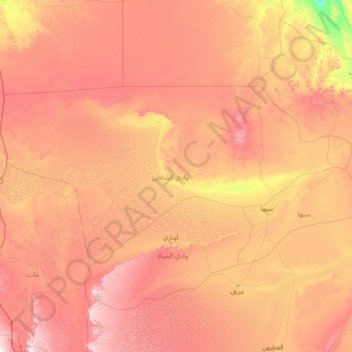
Name: Wadi al Shatii topographic map, elevation, terrain.

Location: Wadi al Shatii, Libya (26.21751 9.83293 28.96982 15.89407)

Average elevation: 1,814 ft

Minimum elevation: 387 ft

Maximum elevation: 4,209 ft

The depression extends east from the town of Ashkeda to the town of Ideary on the west, a distance of about 140 kilometers. To the west, Wadi al Shati borders the Illizi Province of Algeria. After the 2007 administrative reorganization of districts, it borders on the following districts, namely, Nalut in northwest, Jabal al Gharbi in the north, Jufra in the east, Sabha in the southeast, Wadi al Hayaa in the south and Ghat in the southwest. The district is part of Fezzen geographical division of Libya which is mostly full of deserts. The region receives an annual rainfall of 2.5 in (64 mm). There are no perennial rivers in the region, but the region is abundant with groundwater aquifers. Libya has mostly a flat undulating plain and occasional plateau, with an average elevation of around 423 m (1,388 ft). Around 91 per cent of the land is covered by desert, with only 8.8 per cent agricultural land (with only 1% arable lands) and 0.1 per cent of forests. The major resources found in the area is manganese. Along the coastal regions, the climate is Mediterranean, while it is desert climate in all other parts. Dust storms lasting four to eight days is pretty common during Spring. Triplotania is the northwest region, while it is Cyrenacia in the east and Fezzen in southwest.

Wikipedia (CC-BY-SA 3.0)

Other topographic maps

Click on a map to view its topography, its elevation and its terrain.

Awbari

Libya > Wadi al Hayaa

Awbari, Wadi al Hayaa, Libya

Average elevation: 1,729 ft

Nuqat al Khams

Libya

Nuqat al Khams, Libya

Average elevation: 121 ft

Darnah

Libya > Derna

Darnah, Derna, Libya

Average elevation: 279 ft

Ajdabiya

Libya > Al Wahat

Ajdabiya, Al Wahat, Libya

Average elevation: 95 ft

Hun

Libya > District of Al-Jufra

Hun, District of Al-Jufra, Libya

Average elevation: 906 ft

Jabal al Akhdar

Libya

Jabal al Akhdar, Libya

Average elevation: 659 ft

Ghadames

Libya > Nalut

Ghadames, Nalut, Libya

Average elevation: 1,086 ft

Al Qubbah

Libya > Derna

Al Qubbah, Derna, Libya

Average elevation: 1,919 ft

Marj

Libya

Marj, Libya

Average elevation: 627 ft

Ghat

Libya

Ghat, Libya

Average elevation: 2,464 ft

Sabha

Libya

Sabha, Libya

Average elevation: 1,535 ft

Murzuq

Libya

Murzuq, Libya

Average elevation: 2,090 ft

Al Wahat

Libya

Al Wahat, Libya

Average elevation: 413 ft

Shahhat

Libya > Jabal al Akhdar

Shahhat, Jabal al Akhdar, Libya

Average elevation: 1,854 ft

Kufra

Libya

Kufra, Libya

Average elevation: 1,821 ft

Benghazi

Libya

Benghazi, Libya

Average elevation: 226 ft

Wadi al Hayaa

Libya

Wadi al Hayaa, Libya

Average elevation: 1,870 ft

Butnan

Libya

Butnan, Libya

Average elevation: 364 ft

Sirte

Libya > Sirte

Sirte, Libya

Average elevation: 75 ft

Tubruq

Libya > Butnan

Tubruq, Butnan, Libya

Average elevation: 210 ft

Jalu

Libya > Al Wahat > Jalu

Jalu, Al Wahat, Libya

Average elevation: 171 ft

Brega

Libya > Al Wahat > Brega

Brega, Al Wahat, Libya

Average elevation: 10 ft

Zulten

Libya > Nuqat al Khams > Zulten

Zulten, Nuqat al Khams, Libya

Average elevation: 26 ft

Benghazi

Libya

Benghazi, Libya

Average elevation: 75 ft

Zliten

Libya > Misrata > Zliten

Zliten, Misrata, Libya

Average elevation: 115 ft

Cyrene

Libya > Jabal al Akhdar > Shahhat

Cyrene, شحات-سوسه Shahha-Susah, Shahhat, Jabal al Akhdar, Libya

Average elevation: 1,831 ft

Ptolemais, Cyrenaica

Libya > Marj > (Al Dirsiyah (Tolmeitha

Ptolemais, Cyrenaica, طلميثه(الدرسيه)-شاطئ لملكا AlDirsiyah(tlmethah) -lamlaka Beach, (Al Dirsiyah (Tolmeitha, Marj, Libya

Average elevation: 125 ft

Misrata

Libya > Bani Walid

Misrata, Bani Walid, Libya

Average elevation: 39 ft

Bardia

Libya > Butnan > Bardia

Bardia, Butnan, Libya

Average elevation: 266 ft

Tripoli

Libya > Tripoli

Tripoli, Libya

Average elevation: 167 ft

al qalaa

Libya > Wadi al Hayaa > al qalaa

al qalaa, Wadi al Hayaa, Libya

Average elevation: 1,519 ft

Eoj Wahs

Libya > Kufra > Eoj Wahs

Eoj Wahs, Kufra, Libya

Average elevation: 2,123 ft

Mintaqat al Ghanimahغنيمة

Libya > Murqub > Mintaqat al Ghanimahغنيمة

Mintaqat al Ghanimahغنيمة, Murqub, Libya

Average elevation: 194 ft

Bani Walid

Libya > Bani Walid

Bani Walid, Libya

Average elevation: 820 ft

Janzur جنزور

Libya > Butnan > Janzur جنزور

Janzur جنزور, Butnan, Libya

Average elevation: 118 ft

Khoms

Libya > Murqub

Khoms, Murqub, Libya

Average elevation: 171 ft

Marawah

Libya > Jabal al Akhdar > Marawah

Marawah, Jabal al Akhdar, Libya

Average elevation: 1,578 ft

Gebel el Uwaynat

Libya > Kufra

Gebel el Uwaynat, Kufra, Libya

Average elevation: 4,242 ft