
Make a donation
Gear up for your next adventure:
As an Amazon Associate, this site earns from qualifying purchases at no extra cost to you.
Morris County topographic map
Click on the map to display elevation.
Make a donation
Gear up for your next adventure:
As an Amazon Associate, this site earns from qualifying purchases at no extra cost to you.
Morris County
Morris County, New Jersey, features a diverse topography characterized by rolling hills, ridges, and valleys. The western part of the county is dominated by the New Jersey Highlands, part of the Appalachian Mountains, with elevations reaching approximately 1,395 feet (425 meters) above sea level near Pine Swamp in Jefferson Township. In contrast, the eastern section is part of the Piedmont Plateau, offering gentler slopes and elevations around 160 feet (49 meters) at the confluence of the Passaic and Pompton rivers, and featuring the Watchung Mountains, which include prominent ridges. These ridges are composed of basaltic rock formations and extend over 40 miles (64 km) from Somerset County in the southwest to Bergen County in the northeast. The county's terrain is further shaped by several rivers, including the Passaic, Pompton, and Rockaway Rivers, which have carved valleys and floodplains through the landscape. Additionally, glacial activity during the last Ice Age has left behind features such as the Great Swamp, a remnant of the prehistoric Glacial Lake Passaic. Overall, Morris County's topography offers a varied landscape, from the rugged highlands in the west to the rolling hills and river valleys in the east.
Make a donation
Gear up for your next adventure:
As an Amazon Associate, this site earns from qualifying purchases at no extra cost to you.
About this map
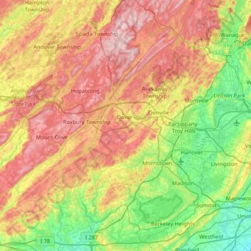
Name: Morris County topographic map, elevation, terrain.
Location: Morris County, New Jersey, United States (40.64952 -74.88877 41.08600 -74.26664)
Average elevation: 597 ft
Minimum elevation: 30 ft
Maximum elevation: 1,398 ft
New Jersey trails, hiking, mountain biking, running and outdoor activities
Make a donation
Gear up for your next adventure:
As an Amazon Associate, this site earns from qualifying purchases at no extra cost to you.
Other topographic maps
Click on a map to view its topography, its elevation and its terrain.
Basking Ridge
United States > New Jersey > Somerset County > Bernards Township
Average elevation: 322 ft
High Point
United States > New Jersey > Sussex County > Montague Township
High Point is a mountain peak within High Point State Park on the border of Wantage Township and Montague Township, Sussex County, New Jersey. Located in the portion of the state known as the Skylands, it is the highest elevation in the state, with a peak elevation of 1,803 feet (550 m). The closest city is…
Average elevation: 1,362 ft
Make a donation
Gear up for your next adventure:
As an Amazon Associate, this site earns from qualifying purchases at no extra cost to you.
Kenvil
United States > New Jersey > Morris County > Roxbury Township > Succasunna
Average elevation: 784 ft
Make a donation
Gear up for your next adventure:
As an Amazon Associate, this site earns from qualifying purchases at no extra cost to you.
Raven Rock
United States > New Jersey > Hunterdon County > Delaware Township
Average elevation: 285 ft
Centerville
United States > New Jersey > Hunterdon County > Readington Township
Average elevation: 161 ft
Make a donation
Gear up for your next adventure:
As an Amazon Associate, this site earns from qualifying purchases at no extra cost to you.
North Stelton
United States > New Jersey > Middlesex County > Piscataway Township
Average elevation: 95 ft
Washington Valley
United States > New Jersey > Morris County > Morris Township
Average elevation: 499 ft
Make a donation
Gear up for your next adventure:
As an Amazon Associate, this site earns from qualifying purchases at no extra cost to you.
Make a donation
Gear up for your next adventure:
As an Amazon Associate, this site earns from qualifying purchases at no extra cost to you.
High Rock Mountain
United States > New Jersey > Warren County > White Township
Average elevation: 620 ft
Downs Farms
United States > New Jersey > Camden County > Cherry Hill Township
Average elevation: 79 ft
Make a donation
Gear up for your next adventure:
As an Amazon Associate, this site earns from qualifying purchases at no extra cost to you.
Make a donation
Gear up for your next adventure:
As an Amazon Associate, this site earns from qualifying purchases at no extra cost to you.
Lincoln
United States > New Jersey > Gloucester County > South Harrison Township
Average elevation: 121 ft
Make a donation
Gear up for your next adventure:
As an Amazon Associate, this site earns from qualifying purchases at no extra cost to you.
Freneau Woods Park
United States > New Jersey > Monmouth County > Aberdeen Township > Henningers Mill
Average elevation: 75 ft
Make a donation
Gear up for your next adventure:
As an Amazon Associate, this site earns from qualifying purchases at no extra cost to you.
Croxton
United States > New Jersey > Hudson County > Jersey City > Journal Square
Average elevation: 52 ft
Make a donation
Gear up for your next adventure:
As an Amazon Associate, this site earns from qualifying purchases at no extra cost to you.
Frost Woods Park
United States > New Jersey > Middlesex County > East Brunswick Township
Average elevation: 95 ft
Make a donation
Gear up for your next adventure:
As an Amazon Associate, this site earns from qualifying purchases at no extra cost to you.
Make a donation
Gear up for your next adventure:
As an Amazon Associate, this site earns from qualifying purchases at no extra cost to you.
Make a donation
Gear up for your next adventure:
As an Amazon Associate, this site earns from qualifying purchases at no extra cost to you.
Make a donation
Gear up for your next adventure:
As an Amazon Associate, this site earns from qualifying purchases at no extra cost to you.
Creesville
United States > New Jersey > Gloucester County > Washington Township
Average elevation: 105 ft
Make a donation
Gear up for your next adventure:
As an Amazon Associate, this site earns from qualifying purchases at no extra cost to you.
Make a donation
Gear up for your next adventure:
As an Amazon Associate, this site earns from qualifying purchases at no extra cost to you.
Middlesex Downs
United States > New Jersey > Middlesex County > Monroe Township
Average elevation: 108 ft
Make a donation
Gear up for your next adventure:
As an Amazon Associate, this site earns from qualifying purchases at no extra cost to you.
Burlington Heights
United States > New Jersey > Monmouth County > Freehold Township
Average elevation: 154 ft
Make a donation
Gear up for your next adventure:
As an Amazon Associate, this site earns from qualifying purchases at no extra cost to you.
Hendrickson Corners
United States > New Jersey > Monmouth County > Middletown Township
Average elevation: 72 ft
Elmer B Boyd Park
United States > New Jersey > Middlesex County > New Brunswick > Feaster Park
Average elevation: 72 ft
Make a donation
Gear up for your next adventure:
As an Amazon Associate, this site earns from qualifying purchases at no extra cost to you.
Kirbys Mill
United States > New Jersey > Burlington County > Medford Township
Average elevation: 49 ft
Make a donation
Gear up for your next adventure:
As an Amazon Associate, this site earns from qualifying purchases at no extra cost to you.
Powder Mill Pond Dam
United States > New Jersey > Morris County > Parsippany-Troy Hills > Tabor
Average elevation: 584 ft
Remsterville
United States > New Jersey > Salem County > Alloway Township > Alloway Township
Average elevation: 49 ft
Make a donation
Gear up for your next adventure:
As an Amazon Associate, this site earns from qualifying purchases at no extra cost to you.
Columbia Lakes
United States > New Jersey > Camden County > Cherry Hill Township
Average elevation: 56 ft
Make a donation
Gear up for your next adventure:
As an Amazon Associate, this site earns from qualifying purchases at no extra cost to you.
Make a donation
Gear up for your next adventure:
As an Amazon Associate, this site earns from qualifying purchases at no extra cost to you.
Van Marters Corner
United States > New Jersey > Monmouth County > Hazlet Township
Average elevation: 20 ft
Charleston East
United States > New Jersey > Camden County > Cherry Hill Township
Average elevation: 75 ft
Make a donation
Gear up for your next adventure:
As an Amazon Associate, this site earns from qualifying purchases at no extra cost to you.
Homes Mills
United States > New Jersey > Monmouth County > Upper Freehold Township
Average elevation: 112 ft
Possumtown
United States > New Jersey > Middlesex County > Piscataway Township
Average elevation: 62 ft
Robinsville
United States > New Jersey > Monmouth County > Upper Freehold Township
Average elevation: 184 ft
Make a donation
Gear up for your next adventure:
As an Amazon Associate, this site earns from qualifying purchases at no extra cost to you.