
Make a donation
Gear up for your next adventure:
As an Amazon Associate, this site earns from qualifying purchases at no extra cost to you.
Barriere topographic map
Click on the map to display elevation.
Make a donation
Gear up for your next adventure:
As an Amazon Associate, this site earns from qualifying purchases at no extra cost to you.
About this map
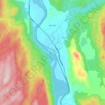
Name: Barriere topographic map, elevation, terrain.
Average elevation: 1,831 ft
Minimum elevation: 1,207 ft
Maximum elevation: 3,166 ft
Make a donation
Gear up for your next adventure:
As an Amazon Associate, this site earns from qualifying purchases at no extra cost to you.
Other topographic maps
Click on a map to view its topography, its elevation and its terrain.
Davis Lake Recreation Site
Canada > British Columbia > Thompson-Nicola Regional District > Area N (Beautiful Nicola Valley - South)
Average elevation: 3,684 ft
Sun Peaks
Canada > British Columbia > Thompson-Nicola Regional District > Sun Peaks Mountain Resort Municipality
Average elevation: 4,888 ft
Kamloops
Canada > British Columbia > Thompson-Nicola Regional District > Kamloops
Average elevation: 2,871 ft
Lac Le Jeune
Canada > British Columbia > Thompson-Nicola Regional District > Area J (Copper Desert Country)
Average elevation: 4,295 ft
Make a donation
Gear up for your next adventure:
As an Amazon Associate, this site earns from qualifying purchases at no extra cost to you.
Cultus Lake
Canada > British Columbia > Thompson-Nicola Regional District > Area J (Copper Desert Country)
Average elevation: 3,389 ft
Bleeker Lake
Canada > British Columbia > Thompson-Nicola Regional District > Area L (Grasslands)
Average elevation: 3,766 ft
Ernest Lake
Canada > British Columbia > Thompson-Nicola Regional District > Area L (Grasslands)
Average elevation: 4,134 ft
Paul Lake
Canada > British Columbia > Thompson-Nicola Regional District > Area P (Rivers and the Peaks)
Average elevation: 3,038 ft
Make a donation
Gear up for your next adventure:
As an Amazon Associate, this site earns from qualifying purchases at no extra cost to you.
Clifford Lake
Canada > British Columbia > Thompson-Nicola Regional District > Area N (Beautiful Nicola Valley - South)
Average elevation: 3,560 ft
Savona
Canada > British Columbia > Thompson-Nicola Regional District > Area J (Copper Desert Country)
Average elevation: 1,575 ft
Powerline Lake
Canada > British Columbia > Thompson-Nicola Regional District > Area L (Grasslands)
Average elevation: 3,986 ft
Monte Lake
Canada > British Columbia > Thompson-Nicola Regional District > Area L (Grasslands)
Average elevation: 2,828 ft
Make a donation
Gear up for your next adventure:
As an Amazon Associate, this site earns from qualifying purchases at no extra cost to you.
Eleanor Lake
Canada > British Columbia > Thompson-Nicola Regional District > Area B (Thompson Headwaters) > Blue River
Average elevation: 2,280 ft
Jacko Lake
Canada > British Columbia > Thompson-Nicola Regional District > Area J (Copper Desert Country)
Average elevation: 3,054 ft
Snohoosh Lake
Canada > British Columbia > Thompson-Nicola Regional District > Area J (Copper Desert Country)
Average elevation: 3,281 ft
Stake Lake
Canada > British Columbia > Thompson-Nicola Regional District > Area J (Copper Desert Country)
Average elevation: 4,432 ft
Make a donation
Gear up for your next adventure:
As an Amazon Associate, this site earns from qualifying purchases at no extra cost to you.
70 Mile House
Canada > British Columbia > Thompson-Nicola Regional District > Area E (Bonaparte Plateau)
Average elevation: 3,566 ft
Mount Cahilty
Canada > British Columbia > Thompson-Nicola Regional District > Area O (Lower North Thompson)
Average elevation: 5,696 ft
Whitecroft
Canada > British Columbia > Thompson-Nicola Regional District > Area P (Rivers and the Peaks)
Average elevation: 3,281 ft
Pinantan Lake
Canada > British Columbia > Thompson-Nicola Regional District > Area P (Rivers and the Peaks)
Average elevation: 3,186 ft
Make a donation
Gear up for your next adventure:
As an Amazon Associate, this site earns from qualifying purchases at no extra cost to you.
Dominic Lake
Canada > British Columbia > Thompson-Nicola Regional District > Area J (Copper Desert Country)
Average elevation: 5,194 ft
Drum Lake
Canada > British Columbia > Thompson-Nicola Regional District > Area M (Beautiful Nicola Valley - North)
Average elevation: 3,825 ft
Kingsvale
Canada > British Columbia > Thompson-Nicola Regional District > Area N (Beautiful Nicola Valley - South)
Average elevation: 3,045 ft
Leonie Lake
Canada > British Columbia > Thompson-Nicola Regional District > Area O (Lower North Thompson)
Average elevation: 3,632 ft
Make a donation
Gear up for your next adventure:
As an Amazon Associate, this site earns from qualifying purchases at no extra cost to you.
Little Fort
Canada > British Columbia > Thompson-Nicola Regional District > Area O (Lower North Thompson)
Average elevation: 1,709 ft
Lower Nicola
Canada > British Columbia > Thompson-Nicola Regional District > Area M (Beautiful Nicola Valley - North)
Average elevation: 2,129 ft
Vavenby
Canada > British Columbia > Thompson-Nicola Regional District > Area A (Wells Gray Country)
Average elevation: 2,106 ft
South Thompson River
Canada > British Columbia > Thompson-Nicola Regional District > Kamloops
Average elevation: 1,381 ft
Make a donation
Gear up for your next adventure:
As an Amazon Associate, this site earns from qualifying purchases at no extra cost to you.
Thompson River
Canada > British Columbia > Thompson-Nicola Regional District
Average elevation: 3,698 ft
Courtney Lake
Canada > British Columbia > Thompson-Nicola Regional District > Area N (Beautiful Nicola Valley - South)
Average elevation: 3,373 ft
McConnell Lake Provincial Park
Canada > British Columbia > Thompson-Nicola Regional District > Area J (Copper Desert Country)
Average elevation: 4,360 ft
Dagger Lake
Canada > British Columbia > Thompson-Nicola Regional District > Area O (Lower North Thompson)
Average elevation: 4,869 ft
Make a donation
Gear up for your next adventure:
As an Amazon Associate, this site earns from qualifying purchases at no extra cost to you.
Edna Lake
Canada > British Columbia > Thompson-Nicola Regional District > Area N (Beautiful Nicola Valley - South)
Average elevation: 4,278 ft
Pritchard
Canada > British Columbia > Thompson-Nicola Regional District > Area P (Rivers and the Peaks)
Average elevation: 1,421 ft
Spectacle Lake
Canada > British Columbia > Thompson-Nicola Regional District > Area O (Lower North Thompson)
Average elevation: 4,685 ft
Dunn Peak
Canada > British Columbia > Thompson-Nicola Regional District > Area O (Lower North Thompson)
Average elevation: 6,995 ft
Make a donation
Gear up for your next adventure:
As an Amazon Associate, this site earns from qualifying purchases at no extra cost to you.
Brenda Lake
Canada > British Columbia > Thompson-Nicola Regional District > Area M (Beautiful Nicola Valley - North)
Average elevation: 5,751 ft
Mount Knouff
Canada > British Columbia > Thompson-Nicola Regional District > Area P (Rivers and the Peaks)
Average elevation: 4,019 ft
Knouff Lake
Canada > British Columbia > Thompson-Nicola Regional District > Area P (Rivers and the Peaks)
Average elevation: 4,098 ft
Blue River
Canada > British Columbia > Thompson-Nicola Regional District > Area B (Thompson Headwaters)
Average elevation: 2,329 ft
Make a donation
Gear up for your next adventure:
As an Amazon Associate, this site earns from qualifying purchases at no extra cost to you.
Pillar Lake
Canada > British Columbia > Thompson-Nicola Regional District > Area L (Grasslands)
Average elevation: 3,350 ft
Spider Lake
Canada > British Columbia > Thompson-Nicola Regional District > Area O (Lower North Thompson)
Average elevation: 4,455 ft
Wasley Lake
Canada > British Columbia > Thompson-Nicola Regional District > Area M (Beautiful Nicola Valley - North)
Average elevation: 4,236 ft
Kanaka Bar
Canada > British Columbia > Thompson-Nicola Regional District > Kanaka Bar
Average elevation: 1,132 ft
Make a donation
Gear up for your next adventure:
As an Amazon Associate, this site earns from qualifying purchases at no extra cost to you.
Shaw Springs
Canada > British Columbia > Thompson-Nicola Regional District > Area I (Blue Sky Country)
Average elevation: 1,549 ft
Alleyne Lake
Canada > British Columbia > Thompson-Nicola Regional District > Area N (Beautiful Nicola Valley - South)
Average elevation: 3,573 ft
Barnes Lake
Canada > British Columbia > Thompson-Nicola Regional District > Area I (Blue Sky Country)
Average elevation: 2,467 ft
Walhachin
Canada > British Columbia > Thompson-Nicola Regional District > Area I (Blue Sky Country)
In December 1914, the westward advance of the CNoR rail head from Kamloops reached Walhachin. The track follows the valley floor at a much lower elevation than the hamlet proper.
Average elevation: 1,437 ft
Make a donation
Gear up for your next adventure:
As an Amazon Associate, this site earns from qualifying purchases at no extra cost to you.
Westwold
Canada > British Columbia > Thompson-Nicola Regional District > Area L (Grasslands)
Average elevation: 2,129 ft
Strait Lake
Canada > British Columbia > Thompson-Nicola Regional District > Area A (Wells Gray Country)
Average elevation: 5,023 ft
Kentucky Lake
Canada > British Columbia > Thompson-Nicola Regional District > Area N (Beautiful Nicola Valley - South)
Average elevation: 3,668 ft
Fatox Lake
Canada > British Columbia > Thompson-Nicola Regional District > Area J (Copper Desert Country)
Average elevation: 3,848 ft
Make a donation
Gear up for your next adventure:
As an Amazon Associate, this site earns from qualifying purchases at no extra cost to you.
Brookmere
Canada > British Columbia > Thompson-Nicola Regional District > Area N (Beautiful Nicola Valley - South)
Average elevation: 3,780 ft
Mount Tod
Canada > British Columbia > Thompson-Nicola Regional District > Sun Peaks Mountain Resort Municipality
Average elevation: 6,316 ft
Sun Peaks Mountain Resort Municipality
Canada > British Columbia > Thompson-Nicola Regional District
Average elevation: 5,213 ft
Riley Dam Recreation Site
Canada > British Columbia > Thompson-Nicola Regional District > Area E (Bonaparte Plateau)
Average elevation: 3,533 ft
Make a donation
Gear up for your next adventure:
As an Amazon Associate, this site earns from qualifying purchases at no extra cost to you.
Thompson Glacier
Canada > British Columbia > Thompson-Nicola Regional District > Area B (Thompson Headwaters)
Average elevation: 7,589 ft
Separation Lake
Canada > British Columbia > Thompson-Nicola Regional District > Area L (Grasslands)
Average elevation: 2,999 ft
Valleyview Nature Park
Canada > British Columbia > Thompson-Nicola Regional District > Kamloops
Average elevation: 1,407 ft
Vimy Ridge
Canada > British Columbia > Thompson-Nicola Regional District > Area A (Wells Gray Country)
Average elevation: 6,138 ft
Make a donation
Gear up for your next adventure:
As an Amazon Associate, this site earns from qualifying purchases at no extra cost to you.
Blue Earth Lake
Canada > British Columbia > Thompson-Nicola Regional District > Area I (Blue Sky Country)
Average elevation: 5,003 ft
Pat Lake
Canada > British Columbia > Thompson-Nicola Regional District > Area J (Copper Desert Country)
Average elevation: 2,188 ft
Chasm
Canada > British Columbia > Thompson-Nicola Regional District > Area E (Bonaparte Plateau)
Average elevation: 3,488 ft
Little Green Lake
Canada > British Columbia > Thompson-Nicola Regional District > Area E (Bonaparte Plateau)
Average elevation: 3,566 ft
Make a donation
Gear up for your next adventure:
As an Amazon Associate, this site earns from qualifying purchases at no extra cost to you.
Spences Bridge
Canada > British Columbia > Thompson-Nicola Regional District > Area I (Blue Sky Country)
Spences Bridge's location is mountainous, with higher elevations part of the Interior Plateau. The east side of the Fraser here is part of the Clear Range, a mountainous southwards extension of the Fraser Plateau located in the angle of the Thompson and Fraser Rivers. Arthur Seat lies in that range on the west…
Average elevation: 1,627 ft
Mount St. Anne
Canada > British Columbia > Thompson-Nicola Regional District > Area B (Thompson Headwaters)
Average elevation: 6,237 ft
Fire Mountain
Canada > British Columbia > Thompson-Nicola Regional District > Area A (Wells Gray Country)
Kostal Cone, also called Kostal Volcano and Fire Mountain, is a young cinder cone in Wells Gray Provincial Park in east-central British Columbia, Canada. It rises from the northeast shore of Kostal Lake in the Cariboo Mountains. With an elevation of 1,440 m (4,724 ft), Kostal Cone is one of the lowest…
Average elevation: 4,318 ft
Dragon Cone
Canada > British Columbia > Thompson-Nicola Regional District > Area A (Wells Gray Country)
Average elevation: 5,587 ft
Make a donation
Gear up for your next adventure:
As an Amazon Associate, this site earns from qualifying purchases at no extra cost to you.
McLeod Hill
Canada > British Columbia > Thompson-Nicola Regional District > Area A (Wells Gray Country)
Average elevation: 3,717 ft
Nicola
Canada > British Columbia > Thompson-Nicola Regional District > Area M (Beautiful Nicola Valley - North) > Nicola
Average elevation: 2,339 ft
Merritt
Canada > British Columbia > Thompson-Nicola Regional District > Merritt
Average elevation: 3,606 ft
Hoodoos
Canada > British Columbia > Thompson-Nicola Regional District > Area J (Copper Desert Country)
Average elevation: 1,539 ft
Make a donation
Gear up for your next adventure:
As an Amazon Associate, this site earns from qualifying purchases at no extra cost to you.
Sparks Lake
Canada > British Columbia > Thompson-Nicola Regional District > Area J (Copper Desert Country)
Average elevation: 3,333 ft
Mount Morrisey
Canada > British Columbia > Thompson-Nicola Regional District > Sun Peaks Mountain Resort Municipality
Average elevation: 4,974 ft
Courtney Lake
Canada > British Columbia > Thompson-Nicola Regional District > Area N (Beautiful Nicola Valley - South)
Average elevation: 3,438 ft
Highland Valley
Canada > British Columbia > Thompson-Nicola Regional District > Logan Lake
Average elevation: 3,904 ft
Make a donation
Gear up for your next adventure:
As an Amazon Associate, this site earns from qualifying purchases at no extra cost to you.
Porcupine Ridge
Canada > British Columbia > Thompson-Nicola Regional District > Area J (Copper Desert Country)
Average elevation: 5,899 ft
Allen Meadows Lake
Canada > British Columbia > Thompson-Nicola Regional District > Area J (Copper Desert Country)
Average elevation: 3,983 ft
Glimpse Lake
Canada > British Columbia > Thompson-Nicola Regional District > Area M (Beautiful Nicola Valley - North)
Average elevation: 3,973 ft
Greenstone Mountain
Canada > British Columbia > Thompson-Nicola Regional District > Area J (Copper Desert Country)
Average elevation: 5,328 ft
Make a donation
Gear up for your next adventure:
As an Amazon Associate, this site earns from qualifying purchases at no extra cost to you.
Black Dome Mountain
Canada > British Columbia > Thompson-Nicola Regional District > Area E (Bonaparte Plateau)
Average elevation: 6,335 ft
Blackstone Glacier
Canada > British Columbia > Thompson-Nicola Regional District > Area B (Thompson Headwaters)
Average elevation: 7,769 ft
Lower Nicola
Canada > British Columbia > Thompson-Nicola Regional District > Area M (Beautiful Nicola Valley - North)
Average elevation: 2,129 ft
Aspen Grove
Canada > British Columbia > Thompson-Nicola Regional District > Area N (Beautiful Nicola Valley - South)
Average elevation: 3,822 ft
Make a donation
Gear up for your next adventure:
As an Amazon Associate, this site earns from qualifying purchases at no extra cost to you.
Arthur Seat
Canada > British Columbia > Thompson-Nicola Regional District > Area I (Blue Sky Country)
Average elevation: 4,354 ft
Quilchena
Canada > British Columbia > Thompson-Nicola Regional District > Area M (Beautiful Nicola Valley - North)
Average elevation: 2,221 ft
Roper Hill
Canada > British Columbia > Thompson-Nicola Regional District > Area J (Copper Desert Country)
Average elevation: 1,594 ft
Spences Bridge
Canada > British Columbia > Thompson-Nicola Regional District > Area I (Blue Sky Country)
Spences Bridge's location is mountainous, with higher elevations part of the Interior Plateau. The east side of the Fraser here is part of the Clear Range, a mountainous southwards extension of the Fraser Plateau located in the angle of the Thompson and Fraser Rivers. Arthur Seat lies in that range on the west…
Average elevation: 1,627 ft
Make a donation
Gear up for your next adventure:
As an Amazon Associate, this site earns from qualifying purchases at no extra cost to you.
Sun Peaks
Canada > British Columbia > Thompson-Nicola Regional District > Sun Peaks Mountain Resort Municipality
Average elevation: 4,888 ft
Sun Peaks
Canada > British Columbia > Thompson-Nicola Regional District > Sun Peaks Mountain Resort Municipality
Average elevation: 4,888 ft
Arthur Seat
Canada > British Columbia > Thompson-Nicola Regional District > Area I (Blue Sky Country)
Average elevation: 4,354 ft
Sun Peaks
Canada > British Columbia > Thompson-Nicola Regional District > Sun Peaks Mountain Resort Municipality
Average elevation: 4,888 ft
Make a donation
Gear up for your next adventure:
As an Amazon Associate, this site earns from qualifying purchases at no extra cost to you.