Andhra Pradesh topographic map
Click on the map to display elevation.
Andhra Pradesh
Renigunta was the first among major stations to appear on the railway map of Andhra Pradesh when Madras railway connected it to Madras in 1862. Rajahmundry-Vijag and Viajayawad-Kovvur sections were opened in 1893. Vijayawada-Madras section was started in 1899. It was extended to Howrah in 1900. As of 2022, The state has a total broad-gauge railway route of 3,969 km (2,466 mi) with rail density at 24.36 km per 1000 square kilometres. The railway network in Andhra Pradesh is under the South Central railway, East Coast railway, and South Western railway zones. During 2014–2022, 350 km of new lines were constructed at a rate of 44 km per year in Andhra Pradesh under the South Central railway division. The rate of construction was only 2 km per year in the preceding five years. The Nadikudi–Srikalahasti line of 308.70 km sanctioned at a budget of ₹22.89 billion (US$270 million) in 2011–12 as a joint project of the centre and state is progressing slowly, with only phase one of 46 km between New Piduguralla station and Savalyapuram completed in 2021–22. There are three A1 and 23 A-category railway stations in the state, as per the assessment in 2017. Visakhapatnam was declared the cleanest railway station in the country, as per the assessment in 2018. The railway station in Shimiliguda is the second broad gauge railway station at high altitude in the country next to Qazigund in Jammu and Kashmir. A new railway zone South Coast railway (SCoR), with headquarters in Visakhapatnam, was announced in 2019, but is yet to be implemented.
About this map
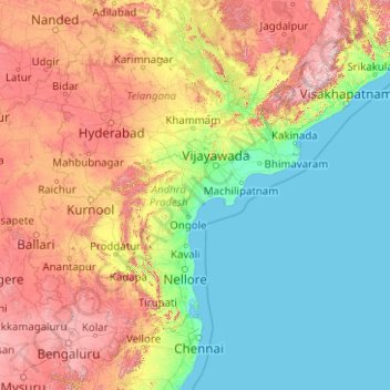
Name: Andhra Pradesh topographic map, elevation, terrain.
Location: Andhra Pradesh, India (12.62386 76.76008 19.16681 84.76580)
Average elevation: 883 ft
Minimum elevation: -3 ft
Maximum elevation: 5,200 ft
Other topographic maps
Click on a map to view its topography, its elevation and its terrain.
Navi Mumbai
India > Maharashtra > Thane > Navi Mumbai
Navi Mumbai (Marathi pronunciation: , also known by its former name New Bombay), is a planned city off the west coast of the Indian state of Maharashtra in Konkan division. The city is divided into two parts, North Navi Mumbai and South Navi Mumbai, for the individual development of Panvel Mega City, which…
Average elevation: 98 ft
Dehradun
India > Uttarakhand > Dehradun
The city of Dehradun mainly lies in Doon Valley and is at a varying height from 410 m (1,350 ft) in Clement Town to above 700 m (2,300 ft) at Malsi which is 15 km (9.3 mi) from the city. However, the average elevation is 450 m (1,480 ft) above sea level. Malsi is the starting point of Lesser Himalayan Range…
Average elevation: 2,966 ft
Surat
India > Gujarat > Katargam Taluka > Surat
Surat is a port city situated on the banks of the Tapi river. Damming of the Tapi caused the original port facilities to close; the nearest port is now in the Magadalla and Hazira area of Surat Metropolitan Region.It has famous beach called 'Dumas Beach' located in Hazira. The city is located at 21°10′N…
Average elevation: 36 ft


Lonavala
India > Maharashtra > Mawal
Adjacent to the Lohagad fort lies the visapur fort which is part of the Lohagad-Visapur fortification. Visapur Fort is larger and at a higher elevation than its twin- Lohagad. It was built during 1713-1720 CE by Balaji Vishwanath.
Average elevation: 2,011 ft
Bengaluru
India > Karnataka > Bangalore North
Bengaluru lies in the southeast of the South Indian state of Karnataka in the heart of the Mysore Plateau (a region of the larger Deccan Plateau) at an average elevation of 900 m (2,953 ft). The city covers an area of 741 km2 (286 sq mi). The Bengaluru metropolitan region covers an area of 7,005 km2 (2,705 sq…
Average elevation: 2,884 ft


Bhubaneshwar
India > Odisha > Bhubaneswar (M.Corp.)
Bhubaneswar is in Khordha district of Odisha. It is in the eastern coastal plains, along the axis of the Eastern Ghats mountains. The city has an average altitude of 45 m (148 ft) above sea level. It lies southwest of the Mahanadi River that forms the northern boundary of Bhubaneswar metropolitan area, within…
Average elevation: 98 ft
Indore
India > Madhya Pradesh > Juni Indore Tahsil
Indore /ɪnˈdɔːr/ (listen) is the most populous and the largest city in the Indian state of Madhya Pradesh. It serves as the headquarters of both Indore District and Indore Division. It is also considered as an education hub of the state and has campuses of both the Indian Institute of Technology and the…
Average elevation: 1,821 ft
Lucknow
India > Uttar Pradesh > Lucknow
Lucknow stands at an elevation of approximately 123 metres (404 ft) above sea level. The city had an area of 402 km2 (155 square miles) until December 2019, when 88 villages were added to the municipal limits and the area increased to 631 km2 (244 square miles). Bounded on the east by Barabanki, on the west by…
Average elevation: 394 ft
Vijayawada
India > Andhra Pradesh > Vijayawada (Urban)
Vijayawada lies on the banks of Krishna river, covered by hills and canals. and at an altitude of 11 m (36 ft) above sea level. Three canals originating from the north side of the Prakasam Barrage reservoir — Eluru, Bandar, and Ryves — flow through the city.
Average elevation: 121 ft
Bhopal
India > Madhya Pradesh > Huzur Tahsil
Bhopal has an average elevation of 500 metres (1401 ft) and is located in the central part of India, just north of the upper limit of the Vindhya mountain ranges. Located on the Malwa plateau, it is higher than the north Indian plains and the land rises towards the Vindhya Range to the south. The city has…
Average elevation: 1,634 ft

Anakapalle
India > Andhra Pradesh > Anakapalle
Anakapalli is located at 17°41′29″N 83°00′14″E / 17.6913°N 83.0039°E / 17.6913; 83.0039, on the banks of River Sarada and at an altitude of 29 m (95 ft). It is spread over an area of 23.28 km2 (8.99 sq mi).
Average elevation: 115 ft
Chennai
Chennai is located on the south–eastern coast of India in the north–eastern part of Tamil Nadu on a flat coastal plain known as the Eastern Coastal Plains. Its average elevation is around 6.7 metres (22 ft), and its highest point is 60 m (200 ft). Chennai is 2,184 kilometres (1,357 mi) south of Delhi,…
Average elevation: 23 ft
Patna
India > Bihar > Patna Rural
Patna is on the southern bank of the river Ganges. The total area of Patna is 250 km2 (97 sq mi). Of this, the municipal area constitutes 109.218 km2 (42.169 sq mi). The suburban area covers 140.782 km2 (54.356 sq mi). It has an average elevation of 53 m (174 ft). A characteristic feature of the geography of…
Average elevation: 167 ft
Prayagraj
India > Uttar Pradesh > Allahabad
Prayagraj's elevation is over 90 m (295 ft) above sea level. The old part of the city, at the south of Prayagraj Junction railway station, consists of neighbourhoods like Chowk, Johnstongunj, Dariyabad, Khuldabad and many more. In the north of the Railway Station, the new city consists of neighbourhoods like…
Average elevation: 299 ft


Mangalagiri
India > Andhra Pradesh > Mangalagiri
Mangalagiri is located at 16°26′N 80°33′E / 16.43°N 80.55°E / 16.43; 80.55. It has an average elevation of 29.08 m (95.4 ft).It is located 22 kilometres (14 mi) north east of the district headquarters, Guntur, and just 15 km (9.3 mi) south west of Vijayawada and also 30 km (19 mi) to the north…
Average elevation: 95 ft



Habra
India > West Bengal > Habra - I
Habra is located at 22°50′N 88°38′E / 22.83°N 88.63°E / 22.83; 88.63. It has an average elevation of 13 metres (42 feet).
Average elevation: 23 ft

Western Ghats
The range starts near south of the Tapti river and runs approximately 1,600 km (990 mi) through the states of Gujarat, Maharashtra, Karnataka, Goa, Kerala and Tamil Nadu ending at Marunthuvazh Malai, Swamithope near the southern tip of India. These hills cover 160,000 km2 (62,000 sq mi) and form the catchment…
Average elevation: 7,300 ft
Dharamshala
India > Himachal Pradesh > Dharamshala
Dharamshala has an average elevation of 1,457 m (4,780 ft), covering an area of almost 8.51 km2 (3.29 sq mi). Dharamsala is located in the Kangra Valley, in the shadow of the Dhauladhar mountains.
Average elevation: 5,843 ft
Bhilai
India > Chhattisgarh > Durg Tahsil
Bhilai lies at 21.21°N 81.38°E in Central India at an elevation of 297m above sea level on the banks of the Shivnath river, a tributary of the river Mahanadi. It covers an area of 341 km2 (132 sq mi).
Average elevation: 958 ft
Sohra (Cherrapunji)
India > Meghalaya > Shella Bholaganj
It has an average elevation of 1,430 metres (4,690 ft) and sits on a plateau in the southern part of the Khasi Hills, facing the plains of Bangladesh. The plateau rises 660 meters above the surrounding valleys.
Average elevation: 3,835 ft
Vrindavan
India > Uttar Pradesh > Mathura
Vrindavan is situated on the west bank of the Yamuna River, about 15 kilometres north of Mathura. "Maps, Weather, and Airports for Vrindavan, India". www.fallingrain.com. Retrieved 6 December 2019.</ref> It has an average elevation of 170 metres (557 feet).
Average elevation: 564 ft

Daulat Beg Oldi
Daulat Beg Oldi (DBO) lies at the northeastern corner of the Karakoram Range, at the northern edge of Depsang Plains at an elevation of 5,100 metres (16,700 ft). The international border with China is 8 km to the north and the Line of Actual Control with Chinese-controlled Aksai Chin is 9 km to the east. Other…
Average elevation: 16,683 ft


Chandrasekharapuram
India > Andhra Pradesh > Tallladumma > Chandrasekharapuram
Average elevation: 436 ft
Panvel
India > Maharashtra > Panvel > Panvel
Matheran is a hill station and a municipal council in the Raigad district in the Indian state of Maharashtra. It is a hill station in Karjat Tahsil and is also the smallest hill station in India. It is located on the Western Ghats range at an elevation of around 800 m (2,625 feet) above sea level. It is…
Average elevation: 246 ft
Mysuru
India > Karnataka > Mysuru taluk
Mysore (/maɪˈsɔːr/ (listen)), officially Mysuru ([ˈmaɪˈsuːɾu] (listen)), is a city in the southern part of the state of Karnataka, India. Mysore city is geographically located between 12° 18′ 26″ north latitude and 76° 38′ 59″ east longitude. It is located at an altitude of 770 m (2,530 ft)…
Average elevation: 2,385 ft
Kannur
Kannur has an elevation of 1.02 metres or 3.3 feet along the coast of the Laccadive Sea, with a sandy coastal area. The city has an 8 kilometres (5.0 mi)-long seashore and a 3 kilometres (1.9 mi)-long beach at Payyambalam. Kannur is located north of Kozhikode, south of Kasargod and Mangalore, west of the…
Average elevation: 43 ft
Guwahati
Professor Abani Kumar Bhagawati of Gauhati University stated that since before there were sufficient wetlands to absorb rainwater and channels to carry excess water to the Brahmaputra, the city did not experience floods. However, human interference has disrupted the natural topography, leading to the current…
Average elevation: 371 ft
Kolkata
Spread roughly north–south along the east bank of the Hooghly River, Kolkata sits within the lower Ganges Delta of eastern India approximately 75 km (47 mi) west of the international border with Bangladesh; the city's elevation is 1.5–9 m (5–30 ft). Much of the city was originally a wetland that was…
Average elevation: 16 ft

Jasdan
India > Gujarat > Jasdan Taluka
Jasdan is located at 22°02′N 71°12′E / 22.03°N 71.2°E / 22.03; 71.2. It has an average elevation of 293 metres (1633 feet). Jasdan is the biggest Taluka place in Rajkot district and has 103 villages. Geographically it is the heart of the Mandava Hills from where most of the rivers of…
Average elevation: 650 ft






Ashta
India > Maharashtra > Walwa
Ashta is a city and a municipal council in Sangli district in the state of Maharashtra, India. It is located at 16°57′N 74°24′E / 16.95°N 74.4°E / 16.95; 74.4. It has an average elevation of 567 metres (1860 ft). The name "Ashta" comes from the legend that Lord Shri Ram established eight…
Average elevation: 1,864 ft

Dankuni
India > West Bengal > Chanditala - II
Located at an elevation of None meters (0 feet) above sea level, city's yearly temperature is 30.28 °C (86.5 °F) and it is 4.31% higher than India's averages. Dankuni typically receives about 150.21 millimeters (5.91 inches) of precipitation and has 150.54 rainy days (41.24% of the time) annually.
Average elevation: 20 ft
Deshnoke
India > Rajasthan > Bikaner Tehsil
Deshnoke is located at 27°47′26″N 73°20′27″E / 27.79056°N 73.34083°E / 27.79056; 73.34083. It has an average elevation of 265meters (869feet). It is served by Deshnoke Railway station.
Average elevation: 892 ft



Maharashtra
Maharashtra is the third largest state by area in India. The Western Ghats better known as Sahyadri, are a hilly range running parallel to the coast, at an average elevation of 1,200 metres (4,000 ft). Kalsubai, a peak in the Sahyadris, near Nashik city is the highest elevated point in Maharashtra. To the west…
Average elevation: 1,568 ft

Tirunelveli
India > Tamil Nadu > Palayamkottai
Tirunelveli is located at 8°43′41.82″N 77°41′43.94″E / 8.7282833°N 77.6955389°E / 8.7282833; 77.6955389, and its average elevation is 47 metres (154 ft). It is located at the southernmost tip of the Deccan plateau. The Tamirabarani River divides the city into the Tirunelveli quarter and…
Average elevation: 112 ft
Leh
Leh (/ˈlɛ/) (Ladakhi: གླེ) is the joint capital and largest city of Ladakh, a union territory of India. Leh, located in the Leh district, was also the historical capital of the Kingdom of Ladakh, the seat of which was in the Leh Palace, the former residence of the royal family of Ladakh, built in the…
Average elevation: 14,088 ft
Mussoorie
India > Uttarakhand > Dehradun
Mussoorie is at an average altitude of 2,005 metres (6,578 ft). To the northeast are the Himalayan snow ranges, and to the south, the Doon Valley and Shiwalik ranges. The second highest point is the original Lal Tibba in Landour, with a height of over 2,275 m (7,464 ft). Mussoorie is popularly known as The…
Average elevation: 5,230 ft


Madurai
India > Tamil Nadu > Madurai
Madurai is located at 9°56′N 78°07′E / 9.93°N 78.12°E / 9.93; 78.12. It has an average elevation of 101 metres. The city of Madurai lies on the flat and fertile plain of the river Vaigai, which runs in the northwest-southeast direction through the city, dividing it into two almost equal…
Average elevation: 453 ft
Chandigarh
India > Chandigarh > Chandigarh
Chandigarh is located by the foothills of the Shivalik Range of the Himalayas in northwest India. It covers an area of approximately 114 km2. It borders the states of Punjab and Haryana. The exact geographic coordinates of Chandigarh are 30°44′N 76°47′E / 30.74°N 76.79°E / 30.74; 76.79. It has…
Average elevation: 1,240 ft