
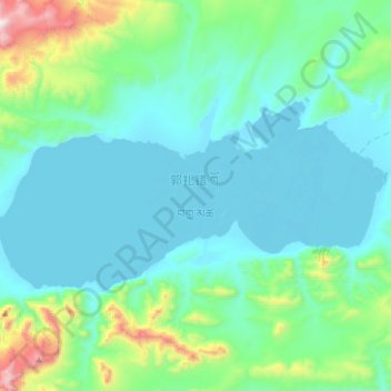
郭扎错 topographic map
Interactive map
Click on the map to display elevation.
About this map
Name: 郭扎错 topographic map, elevation, terrain.
Location: 郭扎错, 东汝, 日土县, 阿里地区, 西藏自治区, 中国 (34.96225 80.91893 35.09125 81.24475)
Average elevation: 17,300 ft
Minimum elevation: 16,657 ft
Maximum elevation: 20,896 ft
郭扎错形状似一面腰鼓,东西长30.4公里,南北最大宽11.6公里,平均宽8.31公里,面积252.6平方公里,最大水深81.9米。湖面海拔达5080米,周围则是海拔5600-5900米的山地和冰川雪山,山体兀立,湖岸比较陡峭。
Other topographic maps
Click on a map to view its topography, its elevation and its terrain.