
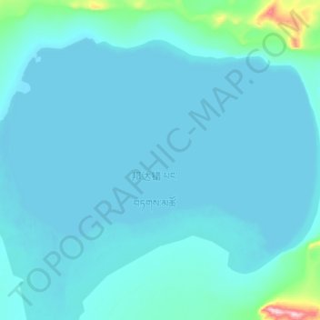
邦达错 topographic map
Interactive map
Click on the map to display elevation.
About this map
Name: 邦达错 topographic map, elevation, terrain.
Location: 邦达错, 东汝, 日土县, 阿里地区, 西藏自治区, 中国 (34.89304 81.48200 34.99604 81.64550)
Average elevation: 16,168 ft
Minimum elevation: 16,086 ft
Maximum elevation: 17,283 ft
邦达错(藏语:པང་བཏགས་མཚོ,威利:pang btags mtsho,THL:Pangtak Tso)曾名雅尔错。位于中国西藏自治区西部阿里地区日土县境内,地处日土县北部,郭扎错以东,呈椭圆形,湖面海拔4902米,面积106平方公里,为一咸水湖,通过饮水河接受其西南部窝尔巴错的泻水。湖区环境恶劣,年均气温-8~16℃,年均降水量75~100毫米。。
Other topographic maps
Click on a map to view its topography, its elevation and its terrain.