
美马错 topographic map
Interactive map
Click on the map to display elevation.
About this map
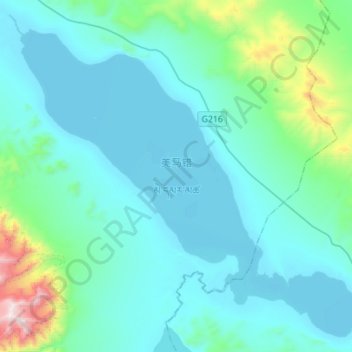
Name: 美马错 topographic map, elevation, terrain.
Location: 美马错, 东汝, 日土县, 阿里地区, 西藏自治区, 中国 (34.10675 82.18150 34.31750 82.45900)
Average elevation: 16,677 ft
Minimum elevation: 16,142 ft
Maximum elevation: 20,584 ft
美马错(藏语:མེ་དམར་མཚོ,威利:me dmar mtsho,THL:Memar Tso)位于中国西藏自治区西部阿里地区境内,地跨日土县和改则县两县,地处昆仑山南麓,湖面海拔4920米,面积140.5平方公里。湖区气候寒冷干燥,年均气温-6~-4℃,年均降水量约75毫米。湖水主要靠南部的阿鲁错和西部山区冰雪融水补给。
Other topographic maps
Click on a map to view its topography, its elevation and its terrain.