
Gravenhurst topographic map
Click on the map to display elevation.
About this map
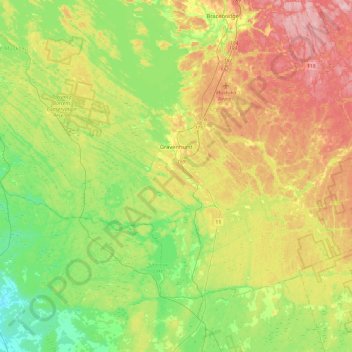
Name: Gravenhurst topographic map, elevation, terrain.
Average elevation: 801 ft
Minimum elevation: 584 ft
Maximum elevation: 1,115 ft
Other topographic maps
Click on a map to view its topography, its elevation and its terrain.
Beausoleil Island
Canada > Ontario > Muskoka District > Georgian Bay Township
Average elevation: 591 ft
Old Big Chute Marine Railway
Canada > Ontario > Muskoka District > Georgian Bay Township
Average elevation: 650 ft
Limberlost Forest and Wildlife Reserve
Canada > Ontario > Muskoka District > Lake of Bays Township
Average elevation: 1,312 ft
Tackaberry Lake
Canada > Ontario > Muskoka District > Lake of Bays Township
Average elevation: 1,109 ft
Riverdale Island
Canada > Ontario > Muskoka District > Muskoka Lakes Township
Average elevation: 774 ft